

[player id=’5332′]
Original article: September 23, 2022
The L Street – K Street Couplet: An engineer’s view
Todd Tregenza works for GHD, the City’s engineering consultant on the Gateway Plan. At the City Council / Planning Commission joint study session on August 23, 2022, he gave a 14-minute presentation about the L Street – K Street Couplet.
While providing a bit more detail than had existed at previous presentations, his talk gave little new information regarding any potential alternatives to the original couplet plan that was outlined in the December 2021 draft Gateway Plan. The images in his presentation are from that draft plan, with some additional illustrations about basic traffic turn patterns and other general background traffic information.
To listen while you read:
The audio player (above) will stay at the top as you scroll down through this article. You can start, pause, repeat, etc. Putting your cursor on the horizontal time-bar will show the time at that point — so you can skip to a specific spot.
Following the presentation is about 20 minutes of questions and discussion. Some of the recorded audio cannot be heard — there are two alternative audio tracks in the article on that meeting, here. I also have a transcription of those questions and answers — just ask.
The full transcription is here, below. The presentation included 21 images. including titles. All are included here. Having the still images here allows you time to really look at and analyze some of the details of these images, more than you’d be able to with watching a video. If you want to watch the video, it’s here.
If you find this presentation to be useful, please write. If you believe there are incorrect or misguided statements, I’d like to hear from you. I have my views, of course, and I like to be clear about what constitutes opinion and what is fact.
To note:
- There is just one depiction of what L Street would be in this plan, at about 1:42:52. A better view is from the draft Plan, which can be seen on this website here. We can note that there is no sidewalk on the West side (the Creamery side) of this proposal. The bike path is shared with pedestrians. This to me seems to be a less than optimal design.

- The small white cars shown in these street depictions are the size of a sub-compact car — the size of a Honda Fit, smaller than a Toyota Corolla, smaller than a Honda Civic. I regard this as misleading and misrepresentative. You can see what a Ford F-150 or a delivery box truck looks like on a one-way one-lane road at The L Street Proposal on this website. Here’s one image from that article, on the right. Look at what a Honda Fit looks like relative to pickup truck or a delivery truck.
- Todd Tregenza’s presentation talks about the benefits of an L Street / K Street couplet. He does not talk about the detriments. Nor does he talk about the benefits of any alternative to this couplet — such as having an L Street park, or redesigning K Street with left-turn lanes. No alternatives are presented at all.
- On the “Concept Evaluation” slide at 1:34:25, there is an image that is worth looking at. The slide says “GHD, Planwest, and the City evaluated a wide variety of options to support future travel demand.” and shows an image with colored arrows on it that represents rejected alternatives. I would like to see those rejected options and hear more about them — perhaps that can be part of a staff report or report from GHD.
General Comments:
And the biggest falsehood of all:
Todd Tregenza:
“And so what we’re proposing with the one-way street conversion would actually look pretty similar to those portions of L Street that have a street today.”
Look pretty similar? I don’t think so.
Putting the southbound traffic from Alliance to Samoa onto a newly created L Street will destroy what the L Street Pathway is today.
- There is much in this proposal that is misleading or even potentially false — and the Council and any advisory Committee should not accept it without a rebuttal presentation.
- Does our future involve more cars or fewer cars? One prospect is that we will indeed be seeing more cars for 20 years or so…and then fewer. To build a new road on L Street is a “forever” change to Arcata. We should not pursue permanent changes to accommodate what is an immediate need, in my view.
- Todd Tregenza referred to a previous study, the Central Arcata Areawide TIS [Traffic Impact Study], which we have not seen: “I think that the delay, the average delay per vehicle was exceeding two minutes.” I find it hard to believe that an average wait was over two minutes.
- As Dave Ryan, Transportation Safety Committee Chair, has noted, we are talking about congestion in a two to four block section of K Street. It is not as though traffic is backed up for blocks. And, as Dave Ryan has also noted, there are other ways of helping traffic flow that the engineers can come up with.
- The issue of crossing K Street is a very real and serious matter. Having K Street be one-lane, one-way certainly would substantially help this situation. But there are other ways of helping with this.
- The presentation talks about the need for “multi-modal” (i.e. vehicles, bicycles, pedestrians) on K Street and L Street. Can we perhaps abandon the concept that L Street also must be multi-modal, and instead support the concept of L Street being completely car-free? (There would have to be some non-contiguous segments of a driveway-type roadway, for access to a small number of parcels.)
- On-Street parking: This was not a part of this presentation, however parking on K Street in this plan goes down to about one-quarter of what it now.
- The City does not have the legal right of way to build a new road on the L Street Pathway. See here and here. (The pictures show the story — You don’t even have to read the text.)
- Crucially, in this plan as proposed, on a future L Street it would not possible for drivers to pass a stopped delivery vehicle. It would not be possible for an ambulance or other emergency vehicle to pass the vehicle in front of it. At around 1:57 in the video Todd says:
“One way street, even with the one way streets we’re talking about, there’s always a parking lane, or a bike lane, which you know, we don’t want cars parked in it. But emergency vehicles could use it if they need to. I don’t, I would not anticipate that being a hurdle to implementation.”But clearly in the depictions of the L Street proposal there are trees alongside the pathway, for the safety and comfort of the bicyclists and pedestrians. It would be impossible for an emergency vehicle to pass.
- And the biggest falsehood of all:
“And so what we’re proposing with the one-way street conversion would actually look pretty similar to those portions of L Street that have a street today.“
No, it would not look “similar” to L Street as it is today.
Putting the southbound traffic from Alliance to Samoa onto a newly created L Street will destroy what L Street and the L Street Pathway is today.
In the left column: The transcription of the presentation. In black.
In the right column: Commentary. In red.


On the audio: 00:16 On the video: 1:30:16
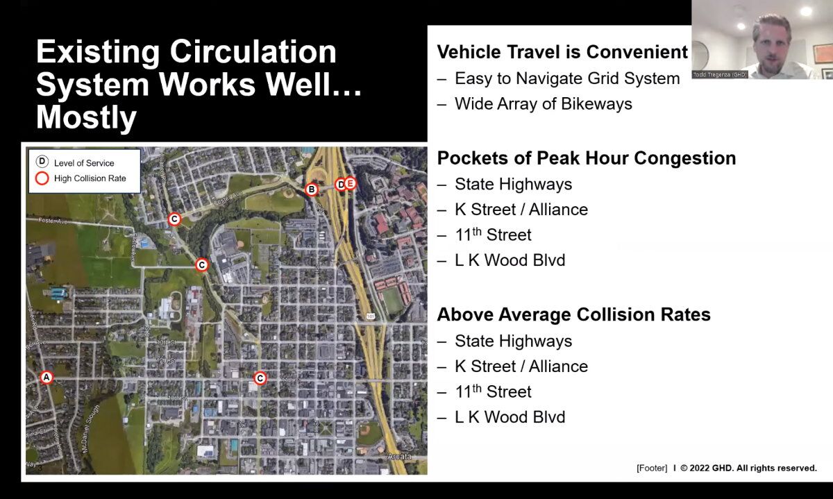
So I first wanted to start with our understanding of the existing circulation system, and that demonstrates really that it works relatively well. You don’t have a horrendous amount of traffic delay on your city streets, the congestion during peak hours is limited to a few specific locations. There are a few locations where the collision rates are above statewide averages for similar facilities. Those are highlighted in the red circle. The level of service for those intersections is the black letter in the middle. And I’ll get into that a little bit more, a couple of slides from here.
But overall there’s an easy-to-navigate grid system, a wide array of bikeways. And generally pretty pleasant place to get around.
On the audio: 01:06 On the video: 1:31:05
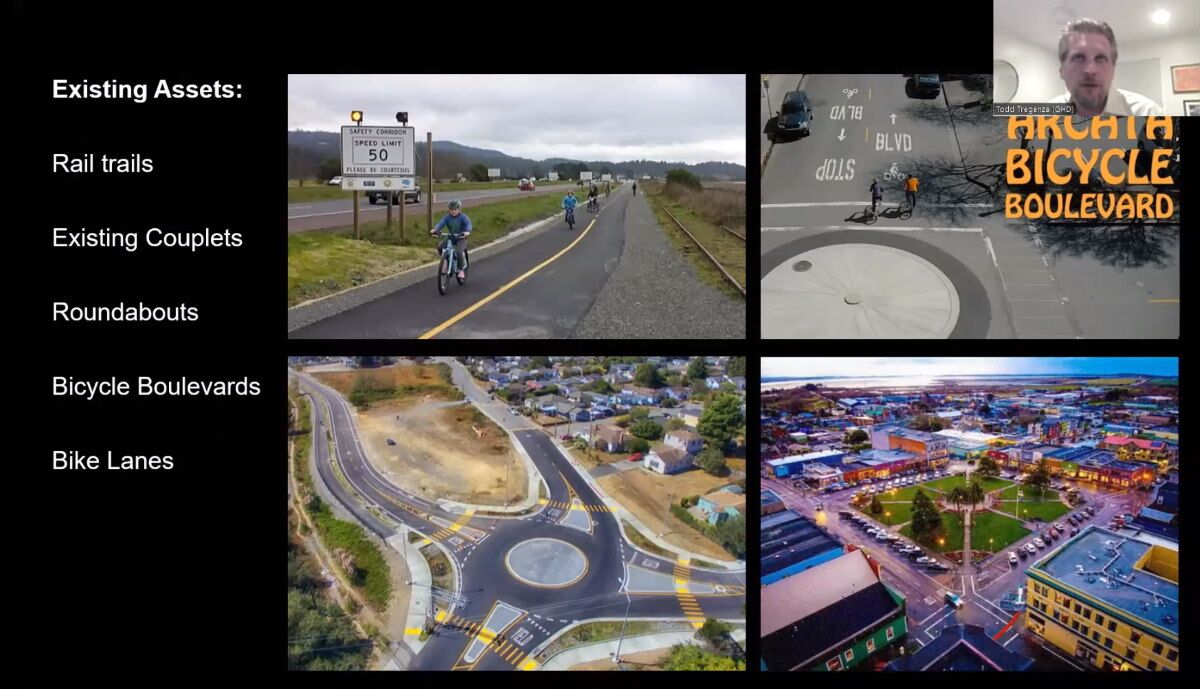
These are some of the assets that I’m sure you’re all familiar with in the City right now.
And one of the things we want to do in this planning process from the get-go, what we heard from our partners that Planwest and the City staff that we were working with, was really build on what’s working today in the City of Arcata and make sure it can work for the future development as well.

On the audio: 01:30 On the video: 1:31:32
So when it comes to assessing future circulation demand, there’s a few things we’ve got to keep in mind.
One is, you know, the development intensity, its location, the mix of uses, how much ability there is to shift modes to other non-automotive uses.
And then what we do is we start looking at the places that are already under some stress. And we can see with some forecasting of growth rates — I think it was David presented some population growth forecasts to the 2045 build-out horizon — because of where the development is located, those growth rates may be quite a bit higher on some streets and lower on others. So you can see, you know, K and 11th, here in the middle of the screen jumps, to a Level of Service “F” with no improvements. Foster and Alliance also, in some of the state highway ramps. And our analysis is actually wider than this. So when you see our full analysis findings, you’ll see that there’s additional study locations that we looked at as well.
I wanted to mention “Level of Service” has gotten a bit of a bad rap recently. And I think in large part that’s due to maybe its role in encouraging suburban and exurban development, you know, basically pushing development away from areas where there’s congestion into areas where there’s ample capacity. But it’s still a remarkably good effective tool to measure vehicle delay, vehicle emissions, whether that’s criteria, health pollutants, you know, things that contribute to asthma, or greenhouse gases that contribute to climate change. It’s a proxy measure for traffic safety — that’s shown even in the first slide where those areas that do have more commute traffic during those peak hours do tend to have a higher collision rate. There is a correlation there. K and 11th, in particular, we see a decent number of broadside collisions, those are definitely collisions we want to avoid.
It also makes it a less pleasant experience to be around, right. If you’re in an intersection or along a roadway that’s full of traffic, it makes it less enjoyable to walk around, less convenient, and arguably less safe as well.

On the audio: 03:54 On the video: 1:33:54
So we’ve been through these numbers, but our circulation system that we were tasked to look at would serve up to 3500 new residential units, plus or minus where we land on the on the land development forecast. We already looked at where that would that would be located. But we wanted to make sure that we supported that not just for vehicles — but build a robust network that really was multimodal.
So looking at really reinforcing those existing multimodal assets, building new ones, and making sure it’s comfortable, convenient, safe for all.
![]()
On the audio: 04:27 On the video: 1:34:27
We looked at a lot of different options. And we didn’t start off with a couplet proposal, that’s for sure. But early on in the process, we did start toying with the idea of what opportunities they may bring to split the northbound and southbound volumes off of K. Some of the drivers in our decision-making were, again, improving multimodal opportunities. But I’m going to jump around a little bit. We’re minimizing roadway capacity expansion, that was a key kind of tenet, we didn’t want to build a lot of new streets. In fact, originally, we didn’t want to build any new streets at all. So the L Street couplet is kind of an exception to that alignment.
We wanted to minimize neighborhood disruptions and maintain available parking on streets. We didn’t want to have to set aside a lot of land for off-street parking.
So we looked at a variety of cross sections, what could be accomplished in your current streets. We looked at those intersections that are congested today during these peak hours and how much worse they’ll get. And we came to the conclusion that, really, you’re going to have to do traffic control. And when we started talking about installing traffic signals, or looking at roundabouts at some of these constrained areas, those would either introduce traffic signals, which are, per your General Plan, not something you prefer. At this time, we want to avoid signalization of local city streets. And roundabouts — while they’re fantastic, I’m a huge proponent — they do require additional right of way.
So we wanted to look at opportunities to accommodate that vehicular traffic that would be generated along the western spine of the city without those two traffic control devices. And the one-way couplet did provide that opportunity.
Is there an implication that one manner of dealing with traffic congestion at 11th & K would be with a traffic signal?
Later there is a discussion of removing some parking and utilizing turn lanes also.
On the audio: 06:20 On the video: 1:36:20
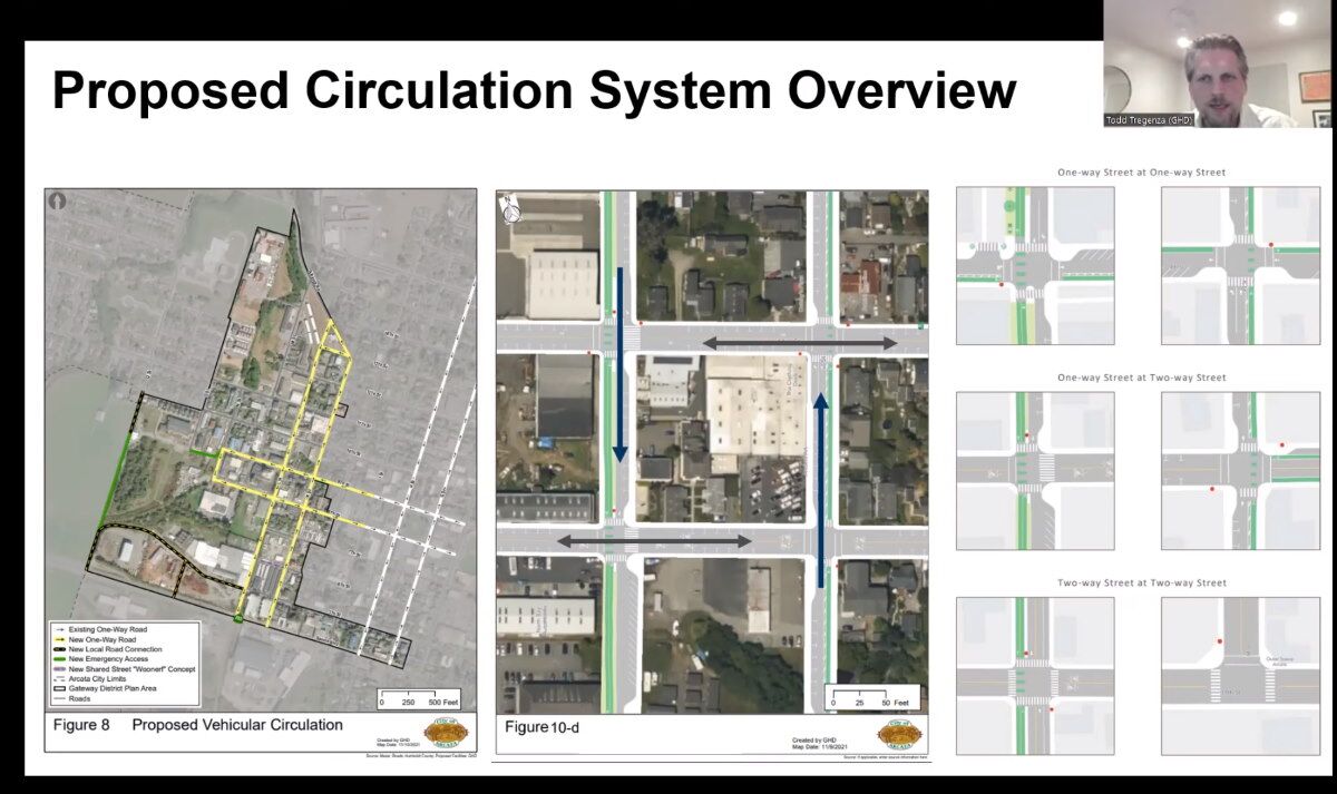
So here is an overview of the proposed plan. It shows the westward extension of the 8th and 9th Street couplets that exists today into the Gateway Area. And the creation of a new North-South couplet system along L and K.
We have a number of different intersection kind of concepts to complement the plan. And we have a lot of illustrations in there that show what things could look like. These are bound to be refined, as development occurs over the next 25 years, and the need for the trigger for these improvements happens. These are high-level planning concepts, but they give you an idea of what — at least in a planning document — the City, per our recommendation, would be looking for in terms of crossing treatments, Class IV bikeways, strong robust multimodal connections.
An incorrect statement:
“It shows the westward extension of the 8th and 9th Street couplets that exists today into the Gateway Area.”
No, the 8th and 9th Street Couplet does NOT exist today into the Gateway area.
The one way sections of 8th and 9th exist currently for three blocks only, between F and I Streets – on the Plaza and on one block on either side of the Plaza.
It is proposed as a couplet leading into the Gateway area — but it does not “exist today.”

On the audio: 07:22 On the video: 1:37:22
This is just a quick screenshot here of the comparison, what happens when you split the traffic off. This is 11th and K.
The first problematic intersection that came to our attention from — actually another study that we hadn’t done, it was a couple years earlier — the Central Arcata areawide TIS [Traffic Impact Study], which anticipated development, although not as much as in the Plan now. So these may actually be understating what the issues would have been with the condition left as it was.
So you see the Level of Service “F” — I think that the delay, the average delay per vehicle was exceeding two minutes. That becomes quite problematic. It’s, it’s not just an “F” — it’s kind of inconvenient. But now you have people waiting two minutes on average to make a move. And that leads to unsafe behavior, people taking gaps that aren’t acceptable people not yielding to pedestrians or cyclists. So it’s not something we want to encourage. And definitely, we want to reduce that to a more acceptable threshold. Moving to a couplet system shown on the right yields to Level Of service “C” Intersection. So that’s a much more reasonable acceptable level of average vehicle delay. You still don’t need any traffic signals, it can be managed with all-way stops by moving those conflicting vehicles into two parallel facilities.
“But now you have people waiting two minutes on average to make a move.”
FALSE
It is not 2 minutes on average.
Average: That means some are 3 minutes, and some are 1 minute? There are certainly plenty of 30 second waits.
When is it ever 2 minutes? Occasionally. Rarely.
This is not to say that K Street has problems. Just not to the degree of “people waiting two minutes on average.“

On the audio: 08:46 On the video: 1:38:46
A variety across sections here, what can be done within the curb-to-curb width that is available to us. Go from a two-way bikeway — which is essentially where we landed on L Street — or you could look at variety of options that introduce more parking, if you want to go there, maybe in the Central Business District, and anywhere from diagonal parking to on street parallel parking, potentially even on both sides.
The small white cars shown in these street depictions are the size of a sub-compact car — the size of a Honda Fit, smaller than a Toyota Corolla, smaller than a Honda Civic. I regard this as misleading and misrepresentative. A Honda Fit is 5-feet 7-inches wide. A Ford F-150 full-size pickup is 8 feet wide including the mirrors. When parked in an 8-foot parking lane with the wheels touching the curb it takes up most of the space. A standard delivery box truck is 8′-6″, as is a school bus, ambulance, fire truck, etc.
You can see what a Ford F-150 or a delivery box truck looks like on a one-way one-lane road at The L Street Proposal on this website.
Parking: The figures shown are arithmetically-derived maximums. The figure of 12, 20, or 24 spaces per block are for an imaginary world in which there are no driveway cut-outs, no corner bulb-outs, no business entrances, no bus stops. There is not a single block in the Gateway Area — and likely not in all of Arcata — that has these theoretical number of parking spaces.
It is a fact — but not widely known or appreciated — that the street designs of the December 2021 Gateway Plan proposal would result in a severe loss of on-street parking. An estimate of the loss is that it would be 25% to 40%. There has been no publicly-available study of this.
Probably the very largest loss of parking would occur on K Street, in the block between 8th and 9th. Currently there are about 16 parking spaces. If the one-lane one-way street were built there according to the draft plan design, the parking spots go from the current 16 to a theoretical number of 6 parking spaces. But of those 6 theoretical spaces shown in the plan, 4 spaces are lost because of the real-world situation of a driveway and a business entrance.
The parking on the block of K Street between 8th & 9th goes from an actual figure of 16 spaces … to an actual figure of 2 spaces in this proposal.
The images and description of the parking on K Street can be seen on this website here — go there, and then scroll down a bit for the K Street discussion.
 On the audio: 09:16 On the video: 1:39:16
This is a handy diagram that shows the vehicular conflict points. So on the left you have two two-way intersections. And it shows the number of vehicle-to-vehicle conflicts that are possible, vehicle to pedestrian conflict, vehicles to cyclist conflict — those are all minimized when you move to a one-way operation. It reduces the chance of collisions.

The diagram on the left is “handy” for Mr. Tregenza because it is pre-made and didn’t take any work from him to include here. But it’s not handy for us. He didn’t even take 5 minutes to Photoshop out “Frontage Road” and “Cross Street” to help us locate where in Arcata this might actually be.
It is not representative of intersections at K Street and L Street. Let’s look closer.
The diagram on the left shows a two-way street — we’ll consider that as 11th Street — that has two two-way streets that intersect it. That is not what we’re discussing in this presentation. In that diagram, the street on the right would be K and the street would be … what? There has never been a consideration of having K and L both be two way. It is a non-pertinent diagram. In other words, it is fluff, noise, nonsense.
The diagrams below are a little closer to our reality here in Arcata.  On the left we have 11th Street intersecting with the L Street Pathway. I have taken the liberty of adding two stop-signs so that pedestrians and cyclists can cross 11th Street with greater safety. At this intersection a driver can only go forward — there are no turns.
A driver at the intersection at K Street (going in any direction) can go forward or turn left or turn right. There is a total of 12 basic movements.
On the right we have the proposal of L & K as one-way streets. The drivers going north (on K) or south (on L) each can go forward or turn left or turn right. The drivers on 11th Street can go either forward or north (at K) or can go forward or south (on L).
There is a total of 14 basic movements.
With appropriate left-turn lanes on K and on 11th, it would seem that the diagram on the left — with L Street as a no-car pathway — would be preferred.

On the audio: 09:41 On the video: 1:39:41
You also reduce your pedestrian exposure to vehicles in physical ways. So, on the left you show, we have a rough concept of what an intersection could look like. And you can see that when you don’t need to accommodate two-way travel anymore at each intersection you can introduce some pretty robust bulb-outs, and those dramatically shorten the amount of distance a pedestrian has to cross the street.

On the audio: 10:11 On the video: 1:40:11
So, in summary, what our proposed plan does is: Enhances multimodal connections, it hits all the drivers that I mentioned earlier. It doesn’t add net new vehicular lanes although it does add a new facility. It’s still one lane per direction. It accommodates future traffic. Minimizes conflict points, improves safety, it eliminates the need for new traffic signals, maintains on-street parking and expands the trail system. That’s something I didn’t mention earlier. But we did propose new trail corridors through the Gateway and throughout connecting into your existing trail system elsewhere.
Excuse me for interjecting. This “engineering-speak” drives me up a wall.
“It doesn’t add net new vehicular lanes although it does add a new facility.” What exactly does “adding a new facility” mean? It means constructing an entirely new road next to where the L Street Pathway now exists. Does it mean ruining the inherent nature of the current L Street Pathway and destroying any possibility of a 10-block Linear Park, a quiet refuge in the center of the Gateway area that would serve as a community gathering area and a refuge from vehicular traffic? Yes, that is exactly what it would mean. And it would mean putting truck traffic along a path that now allows indoor-voice-level conversations and offers the sounds of bird calls.
That is what “adding a facility” means.
Also: “It expands the trail system.” Meaning that there’d be a separate bike lane – adjacent to vehicle traffic – along K Street. That’s a plus. And it puts the existing non-vehicle-associated bike path that’s on L Street and puts it along a truck-filled road.
“We did propose new trail corridors.” This is something that is happening independently of this couplet decision – it is independent of what happens with K Street. Please do not conflate the one with the other.
And to say that new trails are proposed after recommending the ruination of an existing delightful trail is somewhat hypocritical, wouldn’t you say?

On the audio: 10:58 On the video: 1:40:58
What about leaving K Street as-is?
So this is a question we were asked to discuss today.
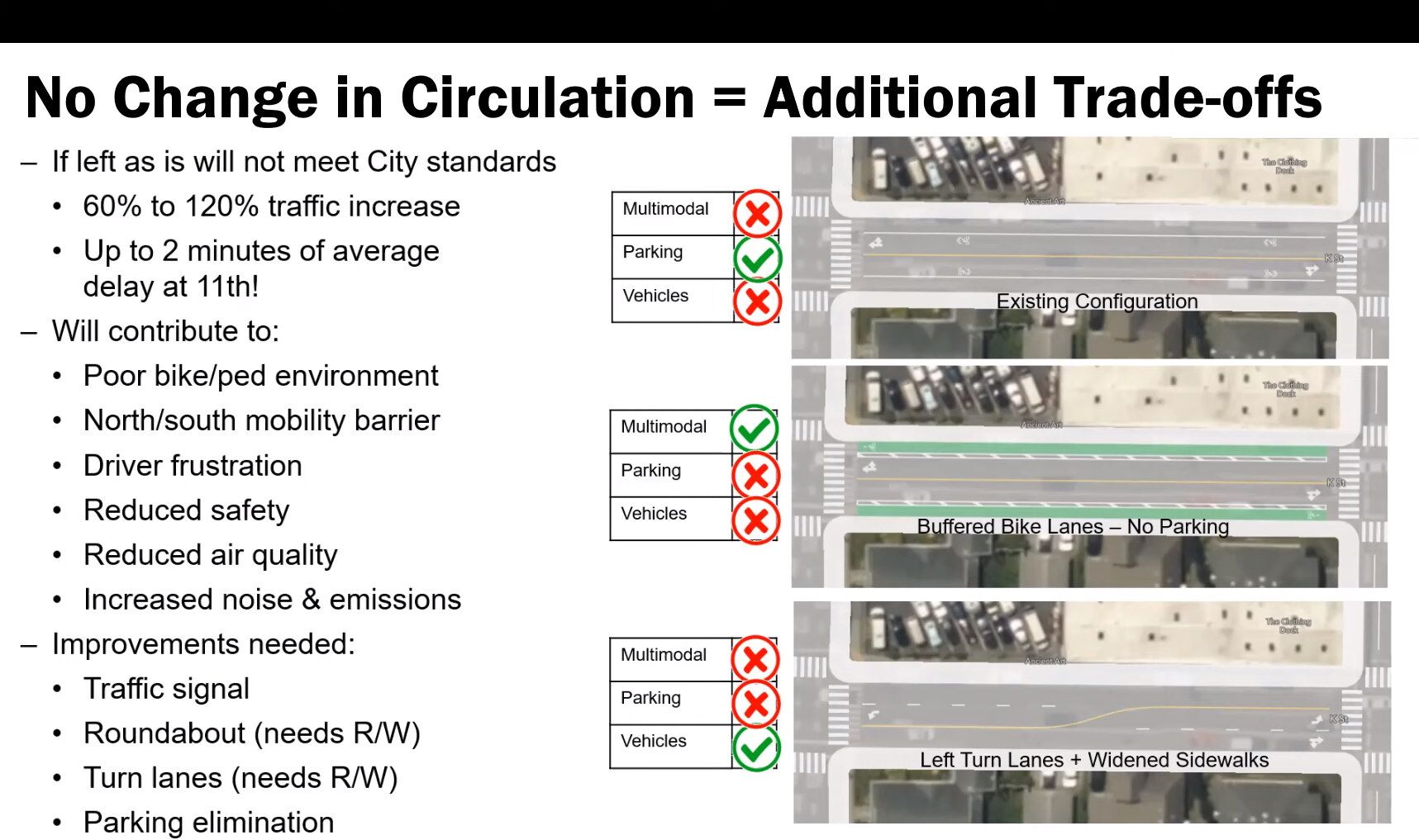
On the audio: 11:04 On the video: 1:41:04
So if you leave K Street as-is, and all the growth we’re talking about occurs without any intervention to the circulation system, you have to make some significant trade-offs. You either leave it completely as it is where — this is kind of the top example up here — parking remains okay but vehicular traffic becomes really problematic, and multimodal conditions really degrade. Today K Street may work all right, off-peak hours, when there aren’t too many cars on the road, people can share the road, there’s “sharrows” out there today. As you increase the volume of traffic, you know, 60% to 100% in some places. So that’s going to become a very stressful environment for a cyclist.
So then your move may be to move to a more multimodal cross section, you can put bike lanes, and then you got to get rid of parking. Alternatively, you say, Hey, you know, the most important thing is to move vehicles efficiently. We don’t want bad emissions and air quality and all of that. And so you introduce left-turn lanes. Well, now you’ve gotten rid of your — you may be able to widen your sidewalks slightly, I think two feet per side. But then now you eliminate your on-street parking and you get rid of your bike lanes.
Cyclists use L Street, one block over, where there would be NO vehicle traffic – none! — if L Street either stays the same or expands into a Linear Park.
Why is this not discussed as an alternative?
Todd Tregenza conveniently does not mention that on-street parking is severely reduced in the couplet plan also. And that more spaces are eliminated with the couplet plan than would be removed if there were left-turns lane at 11th & K and other locations — with K being left as two-way.
As noted previously: On K Street between 8th and 9th there are about 16 parking spaces currently. If the parking layout as proposed in the Draft Plan were put in place, there would be 2 spaces. In other locations, a block with 13 spaces now becomes 5 spaces, and a block where there are 10 spaces now becomes 4.

On the audio: 12:24 On the video: 1:42:24
So our one-way couplet system, you know, trade-offs notwithstanding — understand, you know, that is changing the character of L Street from what it is today — does accomplish those three things. So we thought it was it was it was a good compromise solution, the [it] checked our boxes from a planning perspective, and definitely eager to hear more input from you all tonight from this.
On the audio: 12:48 On the video: 1:42:48
What about the trail along L Street –what might that look like?
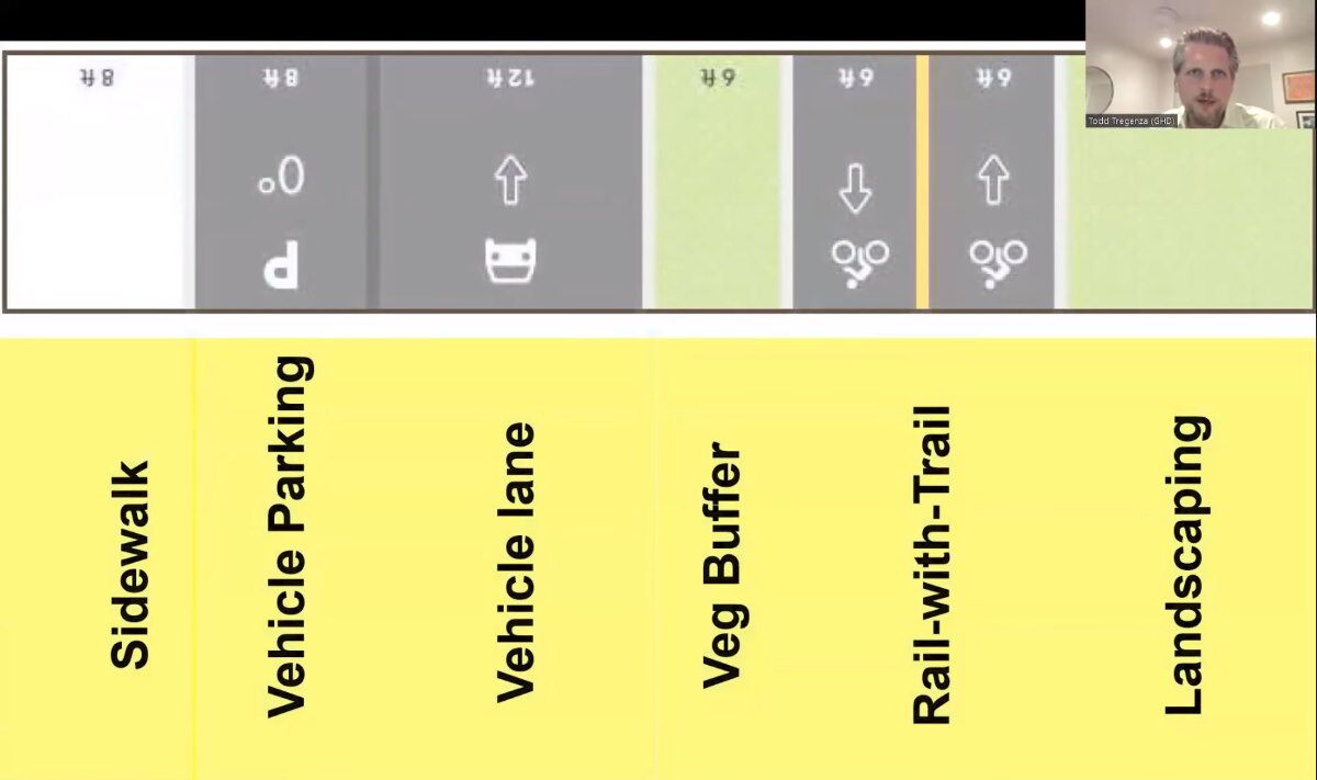
There are many problems with this design, but let’s limit the discussion to the major ones. First, as mentioned, there is no sidewalk on the left (western) side. Bicyclists and pedestrians (and baby strollers and electric skateboards) are expected to share this space.
This is a depiction of a potential street design, as outlined on Page 72 of the December 2021 draft Gateway Plan. You can’t see it, but at the upper right (under the image of the presenter) is the width of that “Landscaping” portion — it’s 12 feet. Adding up all the elements shown here and you get a total of 58 feet for the width of this proposal.
The trouble is that the standard street right-of-way in Arcata is 50 feet. How would a 58-foot proposal fit into a 50-foot right of way? The answer is: It wouldn’t. Something in this diagram has got to be shaved down.
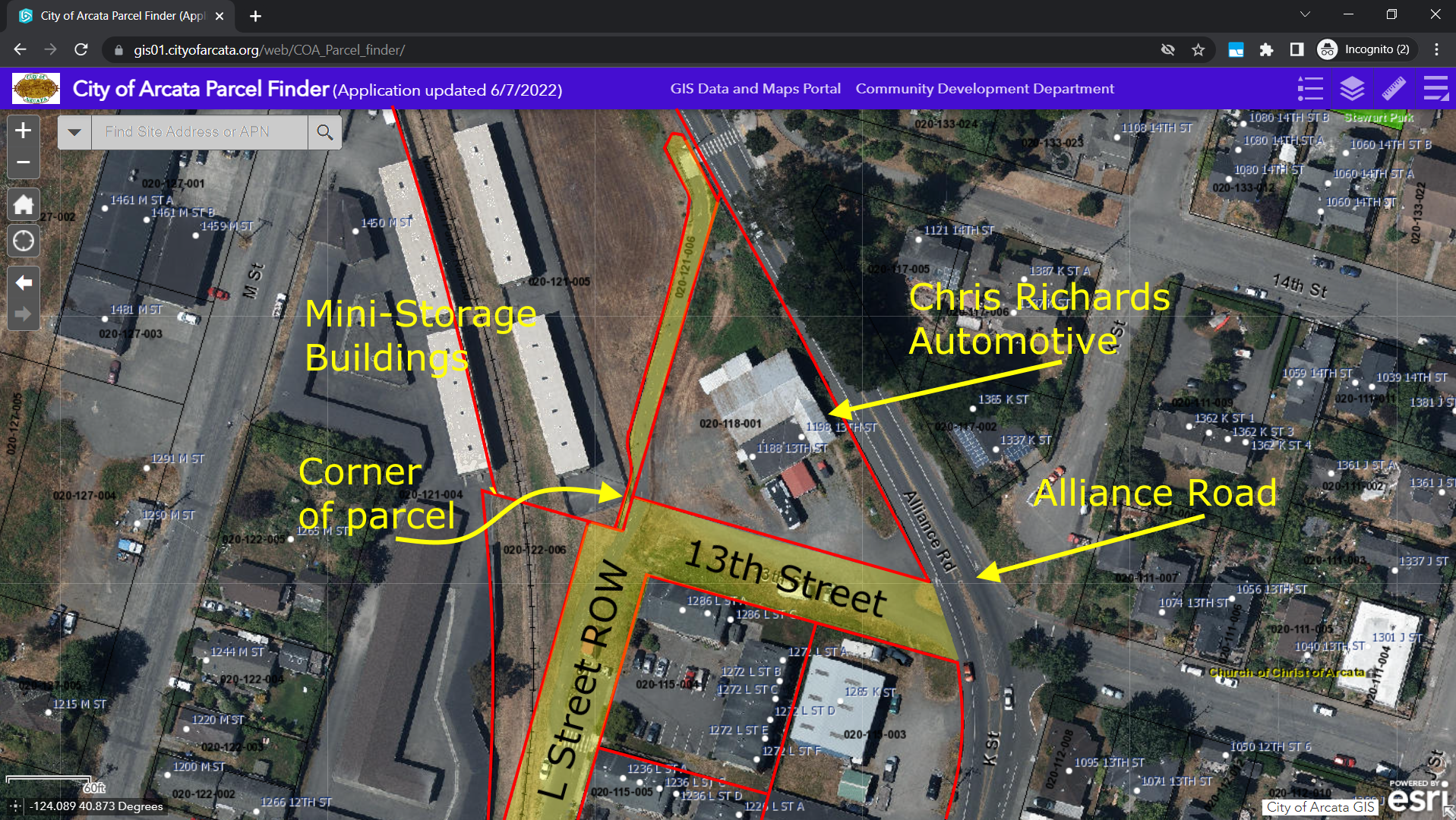
But it’s worse.
In the rail-to-trail area where this new L Street would go, the right of way, according to Arcata’s GIS system, is about 48 feet — maximum. Some places it measures at 46 feet.
Could it be worse yet? Well, at the very north end, the City’s right of way measures just 15 feet wide.
How does a 58-foot wide street fit onto a 15-foot right of way?
And that is the question that many people would like the City planners to address.
For more on this see here and here. (The pictures show the story — You don’t even have to read the text.)
On the audio: 12:52 On the video: 1:42:52
This is the cross section. These are my last few slides, I promise. And I just wanted to show there’s portions of L Streets that are paved today.
Note: Out of 10 total blocks of “L Street” there is a road on one segment that is 3 blocks long, plus one segment that is 1 block long, plus a half-block driveway to the apartments north of 12th Street.
And they are paved more or less as driveways. The segments are discontinuous. There is no through-street. See aerial views and images here.
On the audio: 13:00 On the video: 1:43:00
And so what we’re proposing with the one-way, one-way street conversion would actually look pretty similar to those portions of L Street that have a street today.
There would likely be some curb and gutter installed on the western side as to formalize that. But our cross section maintains the vegetative buffer, maintains that the trail, maintains the landscaping on each side of that, maintains on-street parking and the sidewalks on the east side. So it is similar to what’s out there today where it’s currently paved.
Quote:
“The one-way, one-way street conversion would actually look pretty similar to those portions of L Street that have a street today.”
This is a 100% false statement.
It would not look at all similar to L Street.
Think of K Street as it is today, with cars, motorcycles, pickup trucks, delivery box trucks, UPS and FedEx trucks, the occasional semi-truck, etc. Now think of half of that – just the southbound traffic, but still with cars, trucks, delivery vehicles, etc. Now imagine all that with a bike lane next to it.
That is what L Street would look like.
Opinion: It is intolerable that a consultant to the City would make a statement like this to the City Council, and it is unacceptable that the Council should hear this without a rebuttal response.
The statement is false. We can guess what Todd Tregenza meant here — that the proposed layout of a new street would be similar to that particular 3 block segment of the existing L Street Pathway. In the sense that there would parking on the left, then a one-way roadway, then a vegetation strip, and then a the bike path.
But that is not what he said. He said that it would look the same. It would not look the same.
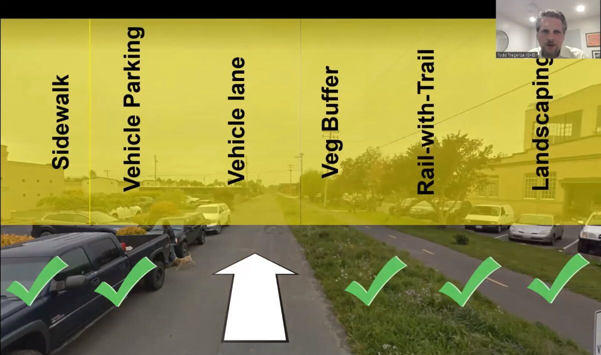
We can point out also:
- In this photo, the vehicles on the left are parked on where the proposed sidewalk would be. The vehicle lane, vegetation buffer, what is shown as “rail-with-trail” (should be “rail-to-trail”) bike path, and the landscaping would all be shifted to the right. In this photo there is not space for a parking lane.
- In this photo, and on the image of the proposed L Street design, there is not a separate bike path and sidewalk on the west side of the proposed street. (The Creamery side.) There is no other location along a street where bicyclists ride on the sidewalk, or people walk on a bike path — which ever way you want to look at it. It would be different if the pathway were an isolated trailway and not alongside what would be a very busy street.
This seems to be a terrible design.

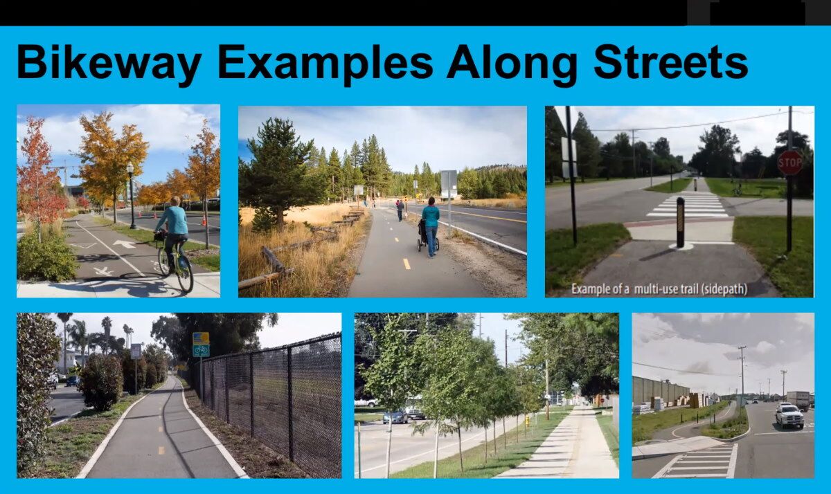
On the audio: 13:40 On the video: 1:43:40
These are just some examples of other places where that is in place. In fact, L Street is right here. And some other examples from around the state and around the nation. That’s all I’ve got.
What is it with these consultants —
With the entire Internet of images to choose from, they cannot find images that are more in keeping with what we are doing here in Arcata? I don’t mean to pick on Todd — the other consultants (including the Form-Based Code consultant, Ben Noble) do this also.
The top right photo shows L Street as it is for two blocks. But I would not call it a “Bikeway example along a Street” — because what we are looking at is not really a street.
The other three “examples” have no bearing at all to our situation here. None whatsoever. Big wide multi-lane streets are in those photos. And those bike paths do not serve double-duty as a sidewalk, as this proposed L Street bike path would.
I ask you personally:
Do you enjoy walking on the sidewalk along K Street?
Of course not. The street is too busy, and it’s all too noisy.
Imagine if there were no parked cars on K Street, and instead there was a six-foot-wide vegetation strip separating you from the K Street traffic. Would that change how the noise or the traffic affected you? Would that six feet of vegetation magically make your walking experience enjoyable or pleasant or comfortable?
That is what is proposed for L Street.
In this proposal, the new L Street would have the entire southbound portion of the existing traffic of what K Street has today. And you would be walking along, trying to enjoy yourself amidst that din, on that sidewalk/bikepath just six or eight feet from that traffic. That’s less than a lane of parked cars. Cars, trucks, motorcycles — six or eight feet away.
So I think I probably went over on time. I apologize for that. But I’m looking forward to — and I can keep all these slides up — but I’m looking forward to your questions and discussion.
Completed on the audio: 14:03 On the video: 1:44:03
Six more photos of bike paths — photos that have little relation to what we have here in Arcata with the L Street Pathway.
We have buildings and residences along the L Street Pathway. The bike path would be next to a single-traffic lane road.
You can judge for yourself: These images are not that.
Video of Todd Treganza’s presentation
Below is the YouTube video of the August 23, 2022 joint study session.
It is cued up to start at the segment for Todd Tregenza’s presentation on the L Street / K Street couplet.
His section is 14 minutes.
Following the presentation is a question-and-answer period with members of the City Council and the Planning Commission.
Significant here is a question from Planning Commissioner Christian Figueroa about the carrying capacity of K Street — in which (if I interpret this correctly) Todd Tregenza states that with proper design of left-turn lanes, a two-way K Street could indeed handle ALL of the projected traffic, even with a build-out of 3,500 housing units in the area.
The YouTube player can be
- Expanded to be full-screen: Use the box at the bottom right corner
- Put on with closed captions: Use the CC icon
- Made faster or slower: Click on the Gear icon and select playback speed.