

The original article “L Street – Proposed design” dates from September, 2022. Updated in May and July 2023 with new photo collages and the dimensions of the proposed L Street.
View the dimensions of what is being proposed as a road for the L Street Corridor, and see how it’s placed in the Creamery District. Click here
Read and sign the Petition for the L Street Corridor Linear Park. Click here
L Street as proposed in the Gateway Plan just wouldn’t fit
Much has been written and said about the Gateway Plan’s L-K Streets couplet design. This proposes that has L Street be created as a one-way truck route street, going along the Creamery Building through the heart of the Creamery arts district.

And much has been written and said about how the City of Arcata does not have the legal permission — the rights of way — to build a new road at the northern area of the L Street Corridor, for the area north of 13th Street. And even north of 11th Street is pretty destructive. See:
- L-K Street Couplet? David Loya says we don’t have the property rights
- The L Street Pathway Deception
- The L Street Pathway Deception
- All L Street Corridor Linear Park articles
There is not enough room for this proposed new road
Even where the City does have the right of way in the Gateway Area, there is not enough space to build this road as it is proposed. We do not know and cannot guess what the City Planners and the consulting engineers were thinking when they came up with this design.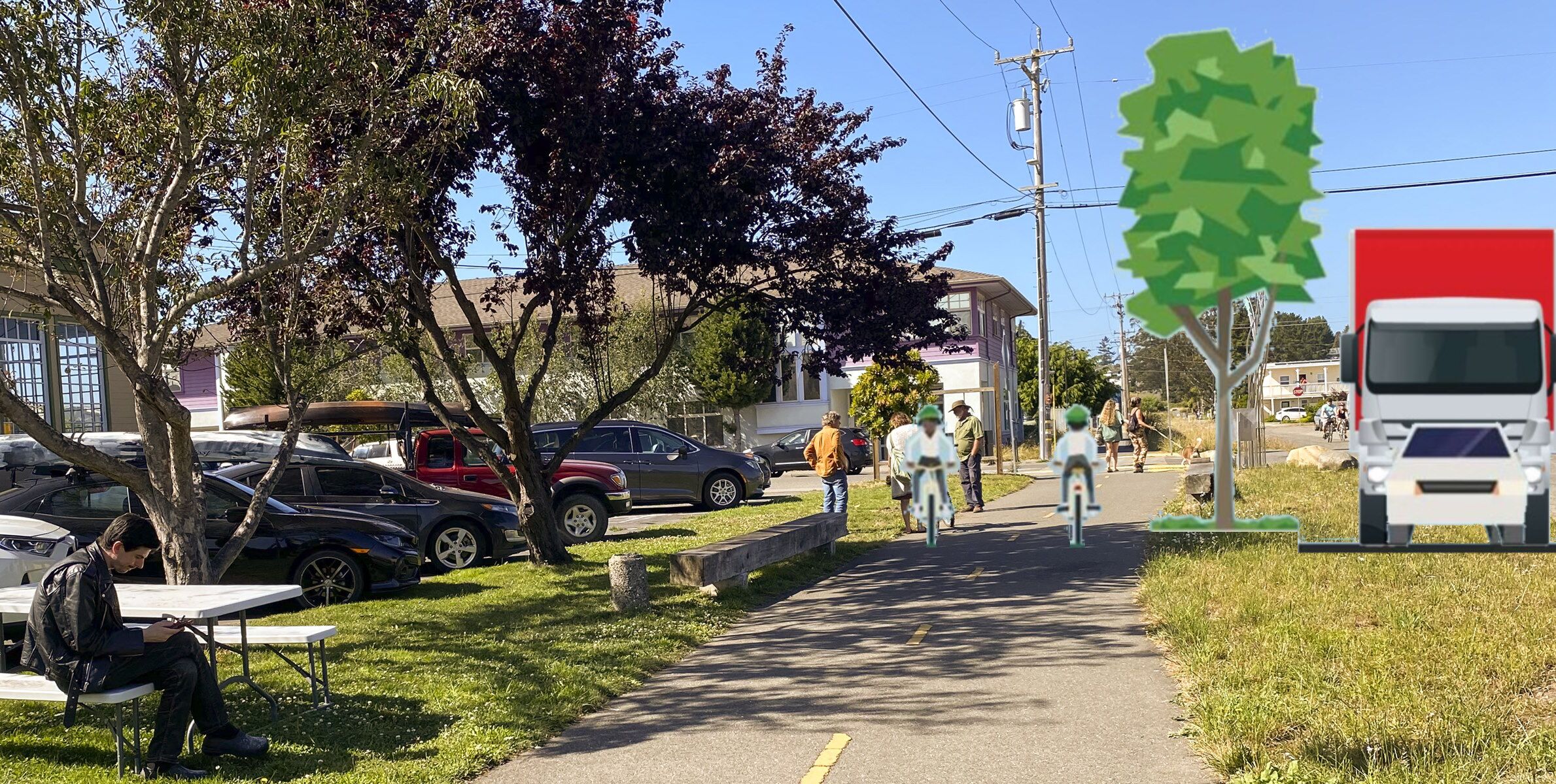
If indeed L Street were to become a through road carrying truck traffic from Alliance Road, there would be some pretty major issues. Let’s look.
Here’s what they proposed for the road running through the Creamery District and beyond. This is what is shown in the December 2021 and October 2022 draft Gateway Plans.

Three things to note:
- There is no sidewalk on the left (west) side. People walking would share the 12-foot wide space with bicyclists. There are no pedestrians shown in the image. Yes, there is no sidewalk on the L Street Pathway currently and the bikes and the walkers share that pathway. But with the way it is now there’s plenty of room to step to the side if you just want to amble or talk.
- The two cars shown are tiny. This makes the road seem bigger than it really is. The cars shown are the size of a sub-compact car — the size of a Honda “Fit” for example. This is smaller than a Honda Civic, smaller than a Toyota Corolla, and far smaller than an ordinary and very typical Subaru.
- The total road width as shown is 58 feet. This is 8 feet wider than the City’s right-of-way, which is 50 feet. To build as shown, the parcel owners would be required to give up 8 feet. This probably will not be an issue in most locations, since it is for a planting strip and thus the width could be adjusted. The eastern end of the Northcoast Children’s Services building, at the northwest corner of 8th and L, would not allow this extra space. Nor would the length of the Tomas Building, at the southwest corner of 8th and L, and the entire length of the industrial building on the west side of L, between 5th and 6th, where Wing Inflatables now is.
- There is no building near L Street that has an open-to-the-air archway-covered walking space similar to what’s show — and it’s not likely there ever will be. It’s a disingenous image.
Let’s put some “normal” vehicles in the picture to see how things look. And replace that sill archway building on the left side with a more reasonable-looking building.
- A full-size Ford Pickup is 8 feet wide, from mirror to mirror. The little Honda Fit-sized car is 5-1/2 feet wide. The height of that Honda Fit-sized car is just a little taller than the height of the sides of the pickup’s bed or hood. This is not a raised grow-dozer truck; just a factory F-150.
- The truck is shown parked all the way up to the curb, and a real driver might not be so good as that. The mirrors on a real truck would likely swing in, so there’d be a little more space there… in theory.
- The box truck shown is taller than an ambulance or fire truck or school bus, but they are all about the same width — about 8-1/2 feet wide including the mirrors.
Contrary to what the City planners would like us to believe, the 6-foot strip between the bike lane and the truck traffic would not reduce the noise very much at all. What is now tranquil would become very noisy.
If you want to know how bad it would be, try walking with a friend along Alliance Road sometime. There are times during the day when most of the traffic seems to be headed southbound. Any attempts to hold a conversation will result in both of you shouting.
Can an ambulance or emergency vehicle fit through here?
By having a raised vegetation strip between the bike lane and the traffic lane, there is no possibility of a driver pulling over if an ambulance were behind that car, or for a delivery truck to pull to the side enough so that someone could pass. If a car were to stall or be in an accident, the vehicles behind it could not get by.
How could a police car or an ambulance get to a person who needs emergency assistance? Well, the emergency vehicle could come in from a side street, starting below (south of) where the accident occurred, and then head north. In theory.
Todd Tregenza of GHD, the engineering consultant, said “One-way street, even with the one-way streets we’re talking about, there’s always a parking lane or a bike lane which, you know, we don’t want cars parked in it. But emergency vehicles could use it if they need to. I don’t, I would not anticipate that being a hurdle to implementation.”
In the drawing above, contrary to Todd’s words: There is no way an emergency vehicle could use a parking lane or a bike lane.
I do not see how an ambulance or other emergency vehicle could possibly pass a vehicle in front of it, on the roadway as shown. Nor how a driver could pull over except at a cross street. And this just does not seem safe.
.
Let’s look at the real dimensions
Here’s the proposed street layout.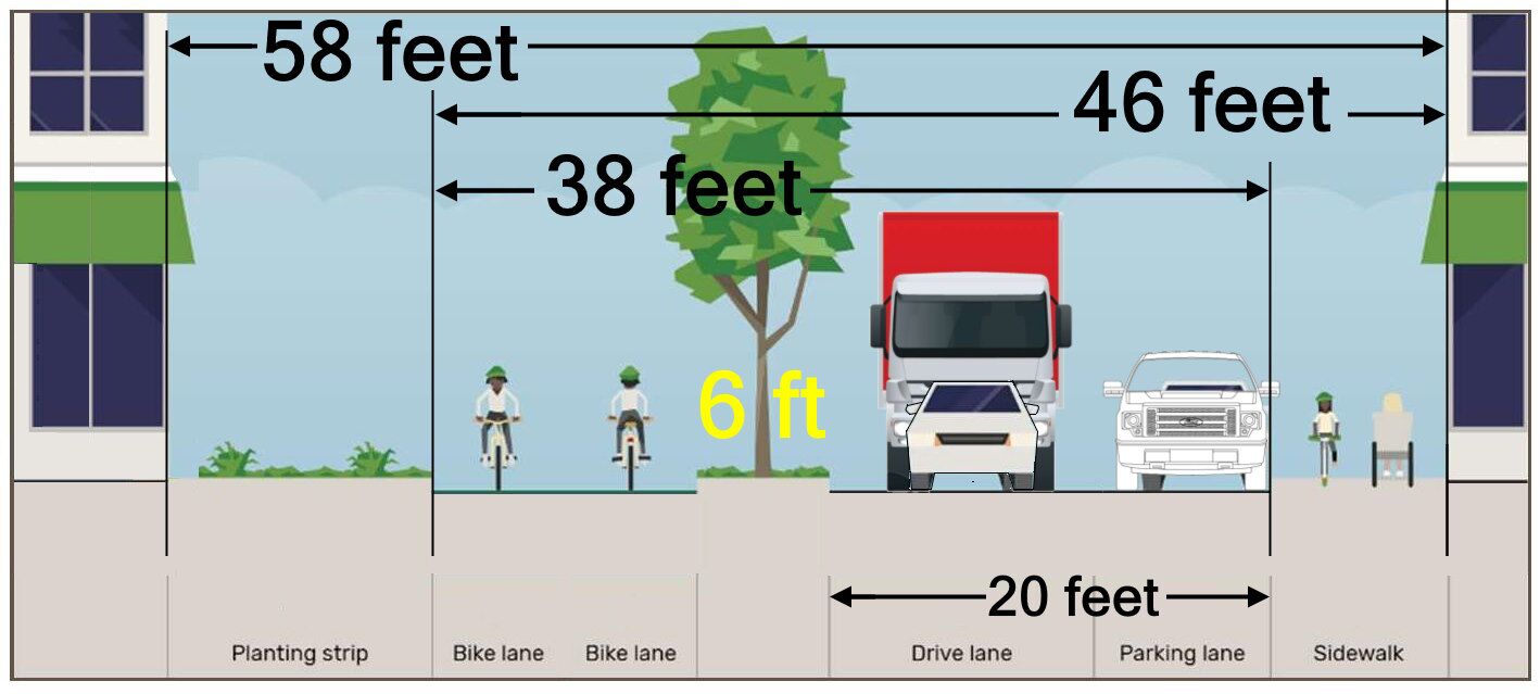


.
Here’s the center of the Creamery District, with the streets and businesses.

A depiction of a truck coming along an imaginary L Street road. Note that the tree “buffer” (or any other vegetation) would not help with the sound — the truck is just too close to people.
.
A depiction of a truck coming passing by the Northcoast Children’s Service building. The cars that are angle-parked on the left side of the photo would be parallel to the roadway if a road were to come in — and would be absent entirely if the L Street corridor were a linear park.