

This article was first published on Arcata1.com on March 11, 2023, over one year ago. Unfortunately, the Gateway Code still contains nothing about the creation and protection of a woonerf and linear park in the L Street corridor.
This article is being given a new date to “bump it up” so more people can take a look at it.
For other articles on Woonerfs and the L Street corridor linear park, tap/click here.
Estimated reading time: 8 minutes
Does a decision need to be made now on the fate of L Street, whether it’s going to be a park or a thoroughfare street, prior to Ben Noble formulating more of the Form-Based Code?
The answer is: Yes.
Contents:
-
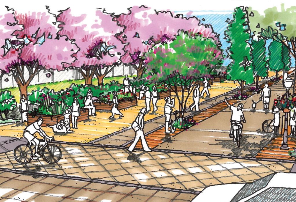
- The L Street Linear Park could be the jewel of Arcata.
- It was specifically called for in the 2010 Rail with Trail Study.
- The L Street Linear Park is precisely what is called for in the Gateway Plan.
Includes excerpts from the Draft Gateway Plan, from Dave Ryan, Chair, Transportation Safety Committee - To make an L Street that handles the south-bound traffic from Alliance to Samoa is a car-centric decision.
- The “Framework” of the Gateway Plan has the City Council making this decision. The Council evaluates the recommendations of the City’s Committees and Planning Commission — and the public.
- Many “opportunity zone” and primary redevelopment parcels have frontage on L Street. The majority of all of the block-size and larger parcels are on L Street.
- A reply from Ben Noble at the Form-Based Code workshop, January 19, 2023
Does a decision need to be made as to the fate of L Street, whether it’s going to be a park or a thoroughfare street, prior to Ben Noble formulating much of the Form-Based Code? YES.
1. The L Street Linear Park could be the jewel of Arcata.
This is the opportunity for Arcata’s Planning Commission
and City Council to take an appropriate leadership position.
Much as the creation of the Arcata Marsh and Wildlife Sanctuary in the in the late-1970s – early 1980s provided vision for what would become both a world-famous wastewater treatment facility and an outdoor environment extraordinaire, the L Street Linear Park is the opportunity for the current generation to bring true innovation to our town.
All over the world cities are taking out roads in favor of linear parks and “walking malls.” Through the efforts of the Rail-to-Trail process and the engagement of the folks of the Creamery District in promoting community engagement (and fun!), we have here the start of a whole “second downtown” — for people. For us.
Use your imagination. I can visualize it. Dave Ryan — Chair of the Transportation Safety Committee — can visualize it. Hundreds or perhaps thousands of people in Arcata can visualize an expanded L Street Pathway right now — because they are already using it every day.
2. The L Street Linear Park was specifically called for in the 2010 Rail with Trail Study.
In June, 2010, the City of Arcata published a 160-page document titled “Arcata Rail With Trail Feasibility Study and Operations Plan.” It is very clear from the engineering plans and the images shown in the document — and on the cover — just what the designers had in mind. See the full article and the 160-page document, link here.
This document was developed over a seven-month period after a previous year of a survey (of over 1100 Arcata residents and visitors), analysis, discussion, and planning. Involved parties included:
-
-
- City Staff: Karen Diemer (then Environmental Service Deputy Director); Mark Andre, Director of Environmental Services; Doby Class, Director of Public Works; Morgan Kessler, Public Works.
- 13-person Steering Committee
- 28 representatives from 19 local organizations or agencies
- North Coast Region Project Manager of the California State Coastal Conservancy agency
- Winzler & Kelly, engineering consultants (since taken over by GHD, in 2011)
- Planwest Partners and Alta Planning + Design, Portland
-
From the document, page 10-1:
The one location where the Arcata RWT interfaces with the street grid network of the City is at L Street. This is a very low volume street with almost exclusively local traffic. This is the ideal location for a shared use street that includes the Arcata RWT. [Rail With Trail]
The following features are included in the design:
-
-
- Mid block bollards to close the street to through traffic, but permit fire access.
- The trees, benches, planters with seatwalls and lights provide pedestrian elements.
- Planters can be used as community garden space.
- Sculpture footings can be placed along the street for art installations.
-
In short, everything that we have been talking about as being desired transportation and quality-of-life benefits to be included in the Gateway Area Plan is in this document — in explicit detail. In looking at it, you may well wonder: “Why go further and try to re-create something that has already been developed?”
3. The L Street Linear Park is precisely what is called for in the Gateway Plan.
Pedestrian and bike-friendly, people-oriented solution to the issues raised by an increased Arcata population. The Gateway Plan is extremely specific about this throughout the plan: Emphasis on people. Reduce emphasis on cars. If cars have to slow down for a 4-block section on K Street because of 11th & K congestion, then so be it. The intelligence of the City’s engineers and consultants can create turn lanes and stop-sign solutions to minimize traffic issues — just as was done on the blocks of H Street when approaching the Plaza.
The draft Gateway Plan is filled with aspirations that are unlikely (or impossible) to come to fruition. But this is one that is spelled out clearly and strongly, and is 100% achievable. The draft Plan has its good points and its bad points (in my view, and the view of many). Reducing dependence on our automobiles is a worthy consideration.
Dave Ryan, Chair of the Transportation Safety Committee points out these sections of the Draft Gateway Plan:
“Reduce trips from other parts of the City and fulfill the potential of the Rail-to-Trail project.” Page 22
“Where the urban grid pattern is interrupted or incomplete, evaluate opportunities to continue the circulation block patterns with new connections that consist entirely of non-vehicular active transportation facilities.” Page 68
“Reduce vehicle trips and parking demand from other parts of the City by creating convenient and safe pedestrian and bicycle corridors that draw residents and visitors into the Plan area via means other than motorized vehicles.” Page 30
“Planning for non-motorized connectivity to other parts of the city with pedestrian and bicycle-friendly corridors that draw residents and visitors to enter the Gateway via means other than motorized vehicles.” Page 68
“As stated repeatedly throughout this document, the Gateway area is envisioned to be a sustainable neighborhood in which residents have the option to live car-free without sacrificing safety or convenience. To do this, transportation needs must be met fully via transit, pedestrian, and bicycle infrastructure that connects seamlessly to all other City destinations.” Page 63
“Consider Non-motorized Campus Layouts. For areas that have incomplete block patterns and/or are currently lacking in vehicular roadways (such as the Barrel District), consider providing limited to no new facilities for motorized vehicles. Instead, consider creating a campus layout with vehicular access on the perimeter and robust non-motorized facilities throughout the interior.” Page 68
[Note: L Street as it is definitely is an incomplete block pattern.]
See the aerial views here.
4. To make an L Street that handles the south-bound traffic from Alliance to Samoa is a car-centric decision.
Let’s get one thing straight from the start: There is no L Street currently. In the ten-block stretch from Alliance to Samoa, there are four and a half discontinuous blocks that are paved enough to drive on. There is no through traffic. The paved areas serve as driveways for people who need the access and for parking. The pavement itself is rutted and pot-holed — because it is not used as a road.
See the photos here.
To make L Street the south-bound conduit for all traffic from Alliance is not converting an existing road. It is building a new road.
At what point in our civilization do we stop building new roads because the roads we have are too congested? Perhaps in 20 years we’ll have self-driving pod-cars that will come to us for our transport needs. Why plan for more cars now? Let’s plan for fewer cars.
For a one-minute visual of what cars have done to us, see Robert Crumb’s “A Short History of America” here on this website. Thoroughly delightful and meaningful to today’s world.
5. The “Framework” of the Gateway Plan has the City Council making this decision.
The Council evaluates the recommendations of the City’s Committees and Planning Commission — and the public.
This L Street Pathway determination is the first large Committee recommendation brought before the City Council. And there will be more. It came to the Council at this earlier stage because of how momentous this decision is. It is truly a “fork in the road” choice. Lots and lots of subsequent decisions and directions in the Gateway Plan will stem from this one decision.
The Framework for the creation of a Gateway Plan that would befit and benefit Arcata involves the City Council receiving — and listening to — a compilation of recommendations from the City’s Committees, the Planning Commission, and the Public.
Is the Council willing to ignore a 5 to zero vote from the Parks and Recreation Committee and a 3 to 1 vote from the Transportation Safety Committee on this issue?
At the August 23rd Joint Study Session, the Council selected the course of “action” to return this matter to the Transportation Safety Committee for reconsideration. The Committee promptly re-confirmed their vote.
K Street will have to be reconfigured – absolutely. For traffic control and, most importantly, to improve the pedestrian and bicycle crosswalk situation.
It may be the case that parking is removed on one side of K Street. This will provide a wider available road width for bulb-outs (to help in crossing the street) and left-turn-lane traffic control.
6. Many “opportunity zone” and primary redevelopment parcels have frontage on L Street.
The majority of all of the block-size and larger parcels are on L Street.
-
-
-
-
- The AmeriGas site
- Bud’s Mini-Storage (possible redevelopment)
- The rear of the Tomas site (where the Montessori garden now is)
- The car wash site
- The Ag Sales building
- The data center — probably a lost opportunity
- The two metal buildings on Samoa at L-K Streets
- And biggest of all: The 2-1/2 block long stretch along L Street of the 20-acres future master-planned area along Samoa where Wing Inflatables currently operates — and shown in the Gateway Plan as the “Barrel District.”
-
-
-
7. A reply from Ben Noble at the Form-Based Code workshop, January 19, 2023
Does a decision need to be made as to the fate of L Street, whether it’s going to be a park or a thoroughfare street, prior to Ben Noble formulating much of the Form-Based Code? YES.
Question:
Do you regard that is correct, that a decision needs to be made as to the fate of L Street, whether it’s going to be a park or a thoroughfare street, prior to you really formulating much of the Form-Based Code?
Ben Noble’s response:
From my personal perspective, we should know what the plan says on that subject. And that the code should reflect the contents of the plan on that subject.
Below is further transcription from that meeting, for the context of the Ben Noble quote above.
From the Form-Based Code workshop with the public with Ben Noble, January 19, 2023
Starting at about 1 hour 24 minutes on the video. Highlights added.
Fred Weis:
Ben, you’re undoubtedly aware of the L Street – K Street question that the Draft Plan proposes — making K Street one-way going north, and L Street one-way going south. And there’s a lot of people who would like to see L Street be made into a Linear Park. The question is: It seems to me that this has to be firmly established before any real progress in the Form-Based Code would take place. Currently, buildings on L Street or K street could be six-story. [Or proposed as 5-story.] But if there’s a linear park on L Street, then those buildings, I don’t think, would be six-story nor would the backs of the buildings on K Street that face L Street would be. It seems to me that they would taper down to something more reasonable like two or three stories. So what I’ve been pushing for is a decision on this, prior to your work. I don’t know if you’re prepared to say anything about this now, but do you regard that is correct, that a decision needs to be made as to the fate of L Street, whether it’s going to be a park or a thoroughfare street, prior to you really formulating much of the Form-Based Code?
Ben Noble:
From my personal perspective, we should know what the plan says on that subject. And that the code should reflect the contents of the plan on that subject. Whether or not that needs to be called out as a sort of discrete decision by the decision makers is something that, you know, is above my paygrade and which would need to be decided.
Fred Weis:
Okay. Good answer. I’m in favor of it being a linear park, which opens up to all kinds of storefronts and eating establishments and things that would be part of that kind of a park-like environment, which I think would be an outstanding center for Arcata, but that’s, again, my opinion. Thanks. Thanks very much.
Ben Noble:
You know, we’re in a position where there is a draft plan that’s being reviewed, and it will evolve over time, as it goes through the public review process. And I anticipate that the draft code, once it’s prepared, it will evolve as well, reflecting changes that occur in the plan. So, my experience is that, you know, you can sort of proceed with this work even if there’s some decisions that have not been fully made — with the ability to circle back and make revisions as needed, depending on how the plan itself evolves over time. That is my perspective on that.
Colin Fiske:
I just wanted to comment that, from my perspective, this issue of of L and K Street, what’s being talked about as a linear park, for L Street would still be a bicycle and pedestrian corridor, you know, not just for recreation, but for transportation, as currently exists through much of that corridor, a class one trail or, or even greater standards. And so from my perspective, you know, what Fred is sort of talking about with, you know, inviting storefronts and so forth. It doesn’t really change the facade, or height or anything like that very much. Because what we want on all the streets is a pedestrian-oriented, you know, façade, and that’s going to be a pedestrian corridor where there are cars they’re not. So that’s, at least, that’s my perspective. Thanks.
[Note: It would absolutely change the height requirements –Because we’d want pedestrian-oriented buildings that let in a maximum of daylight onto the linear park area.]
Ed Hirsch:
Well, on that point that Fred and Colin are making, since we’re talking about L Street. Having it be a linear park is certainly much more pedestrian-friendly than having cars on it.
We don’t have cars on it now and encouraging more traffic on that road doesn’t seem to be highly pedestrian-friendly. Things happen. We know that because of that horrible accident the other day. So a place that people are already recreating, walking, biking, not having to interact with cars. I’m all for keeping it as a linear park. That’s my comment.
[Note: Ed Hirsch is referring to the traffic death on January 17, 2023, on Alliance Road just north of Foster Avenue. Twenty-one year-old Cal Poly Humboldt student Camile Nauta was walking on the sidewalk and was killed when a pickup truck veered off the road for unknown reasons. Another pedestrian was injured.]