

Below is a blog entry from Brian Palmquist of Vancouver (Canada) who has been an architect for 40+ years and has worked with urban developers. What he writes is called “City Conversations.” And what does he talk about ? A City plan to double building height and housing density. He calls his blog entry: “The Beginning of the End ?“
Does any of this sound familiar to us here in Arcata?
Here’s what he discusses:
- Lack of transparency from City Hall. Pertinent facts are hidden.
- Trying to push this change to the city’s zoning through too quickly, with insufficient public input. In Vancouver, the plan was announced and then the City expected it to be approved by the City Council in just two months.
- Changing the height limits to 40 stories in neighborhoods with what looks like a 8-12 story limit other neighborhoods go from 6 to 12 stories. For perspective, 6-stories is considered to be a liveable urban height, i.e. London, Paris. Hi-rise cities include NYC, Chicago, Shanghai — a very different feel.
- The City’s plan is filled with promises and platitudes, but no substance about how to achieve them.
- No considerations for schools, parks, community centers, playing fields, etc.
- No 3D modeling from the City of what a build-out would look like.
- Oversimplified or misleading (i.e. false) depictions of solar shading.
- Catering to what makes it easier for developers.
- No consideration from the City of what adding 100,000 housing units would be. Vancouver BC population is around 650,000 — this plan would increase the downtown population by perhaps 25% or 30%. (Vancouver metro area is ~2.6 million.)
- No discussion of the cumulative effects.
- In one neighborhood, the population is currently 33,000 and could increase by 25,000 — that’s 75%.
- “Consolidating” Vancouver’s 20+ neighborhood areas into six made-up neighborhood “types.”
His full blog entry is here, below.
Here’s his original the blog site: https://brianpalmquist.substack.com/p/feint-by-numbers-1477the-beginning?s=r
And his blog covering the introduction of the Vancouver plan is at: https://brianpalmquist.substack.com/p/fighting-for-the-soul-of-vancouver?s=r
He wrote: “In the absence of modelling information from the City we used Google Earth…” Much like the images on this website. In the absence of modelling about the Gateway plan from Arcata’s Community Development Department (nothing supplied, after many promises, here at 5 months after the draft plan was presented), Google Earth images are an alternative.
Note the 3D model images that he has. They gives a far more understandable idea of what a build-out would look like. Looking at colors on a map is simply not as effective — there’s a visceral punch in seeing an image of all those high-rise buildings.
The cityscape would go from this …

… to this:

Another image, of just a part of the development area. Note the low buildings on the left side of the towers. That’s what is there now. Any regard for solar shading or human scale? Perhaps the City is saying: Who cares?

Here’s his full blog entry, below. Notes: References to “1477” is a building planned for 1477 West Broadway. The term “FSR” is the floor space ratio. It is the same as “FAR” which stands for floor area ratio. The two terms are identical — they refer to the ratio of the gross floor area of a building to the size of the piece of land that the building is built on.
(In transferring it here, some of the original formatting is changed. You can look at his original at: https://brianpalmquist.substack.com/p/feint-by-numbers-1477the-beginning?s=r
Feint by Numbers: 1477…the Beginning of the End?
1City Conversation #43: 1477 West Broadway is the leading edge of a Vancouver wedge issue called The Broadway Plan
| Brian Palmquist Apr 14 2022 |
April 14, 2022—The proposed spot rezoning for this project may be approved this evening after a public hearing at which more than 50 folks will speak. I am #14 on the list. You only have until 5pm to lodge your opinion at https://vancouver.ca/your-government/contact-council-public-hearing.aspx —go there, indicate “1477 West Broadway” as the address and indicate if you support or oppose this project. My remarks follow:
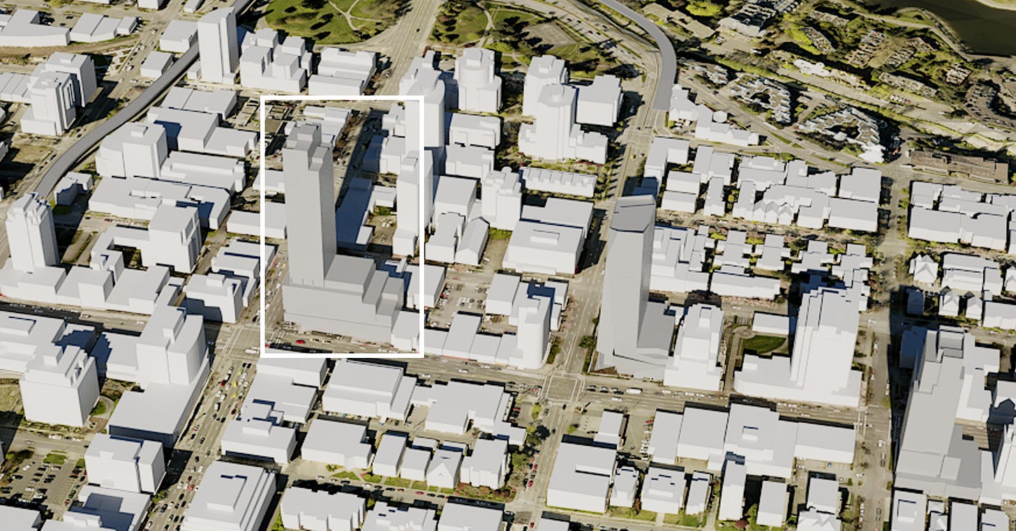
Figure 1 – This illustration from my PowerPoint shows 1477 West Broadway in its pre-Broadway Plan context
“Thank you for the opportunity to speak in opposition to the proposed spot rezoning at 1477 West Broadway. This proposal was introduced and moved forward to this point on the basis that it is consistent with the as-yet-unapproved Broadway Plan, so I will focus on that context.”

Figure 2 – The overall area of the Broadway Plan—7% of the entire area of Vancouver
The Broadway Plan proposal stretches across parts of the Kitsilano, Fairview and Mount Pleasant neighbourhoods—but not all of them. It creates more than 50 new zoning districts, all different than these neighbourhoods’ existing 24 zonings districts. It’s taken some time to unravel the overlaps, the many new zones, etc.
In Figure 2 above from the Broadway Plan proposal, the location of 1477 West Broadway is noted in the smaller white box to the centre left of the diagram.
The slightly larger white box shows the limits of the modelling that Stephen Bohus, BLA and I have undertaken—the areas modelled are only a small subsection of the Broadway Plan area.
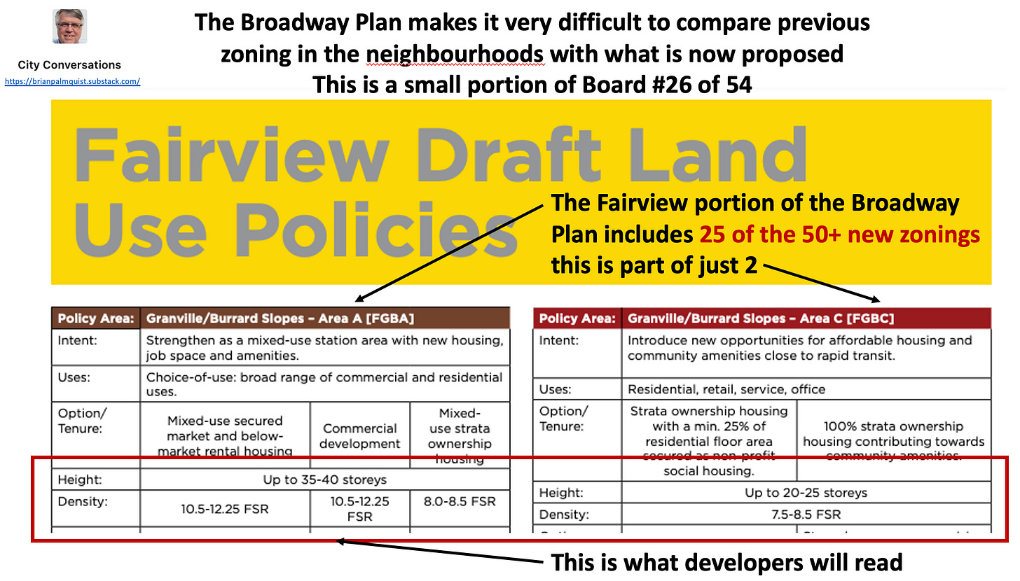
Figure 3 – 50+ new zonings come down to just a few bits of data
The Broadway Plan is described in 54 “boards.” Figure 3 is just a portion of one board, including parts of two of the 25 proposed new zonings.
As an experienced architect and urban designer, I have worked with many developers in my career, so I know that when they read the zonings they will simply focus on the items in the red box—how much can I build and how high can I go?
There’s nothing wrong with that focus, but it informs the models that follow.
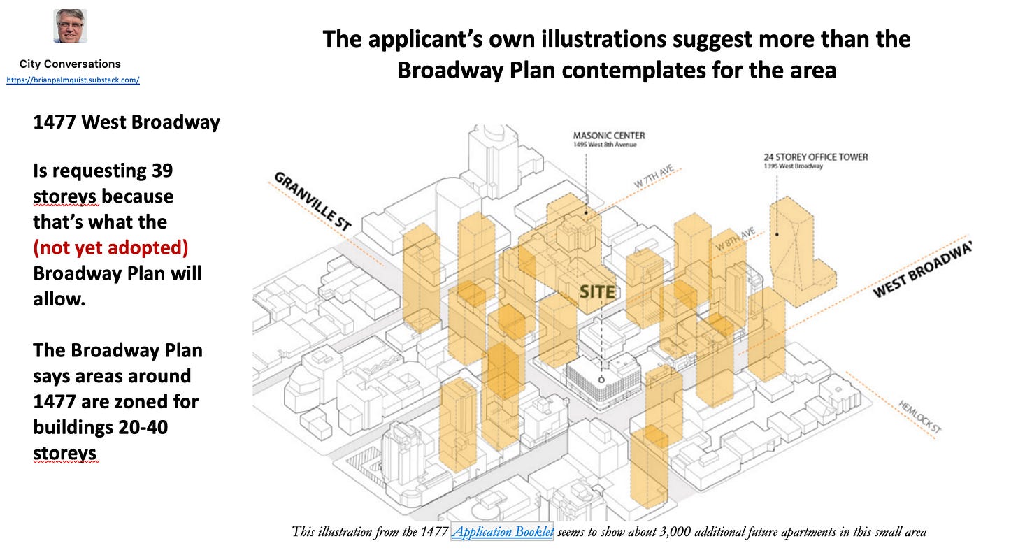
Figure 4 – the applicant’s suggested building massing around 1477
The applicant’s proposal is for a 39-storey mixed use building. Their own context diagram in Figure 4 suggests what the surroundings of their building might look like. This forms one of the bases for our modelling.
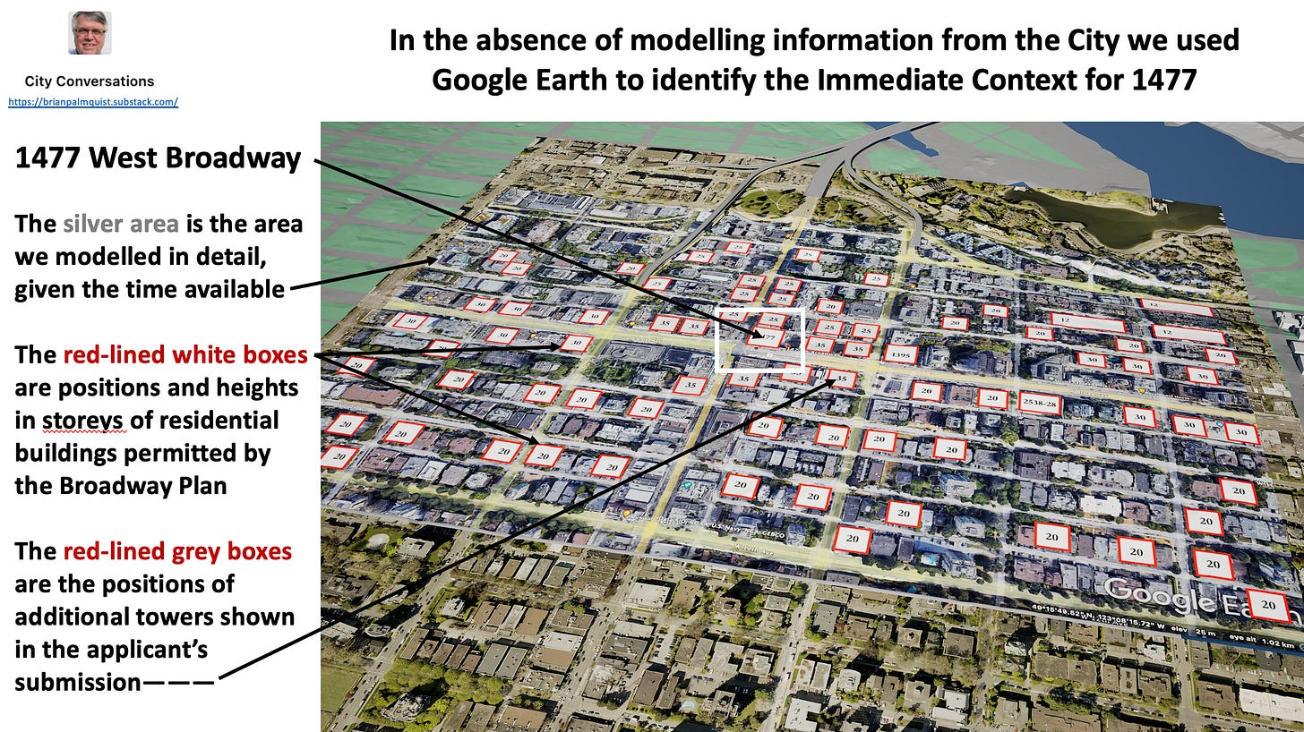
Figure 5 – How we built the Broadway Plan Model, Part 1
In Figure 5, the area in silver is the area of the Broadway Plan centred around 1477 that we modelled. I identified what the Plan would permit within the silver area—those are the red-lined white boxes.
The red-lined light grey boxes around 1477 are the positions of buildings suggested in the applicant’s submission.
From this information, Stephen Bohus, BLA, created the images that follow.
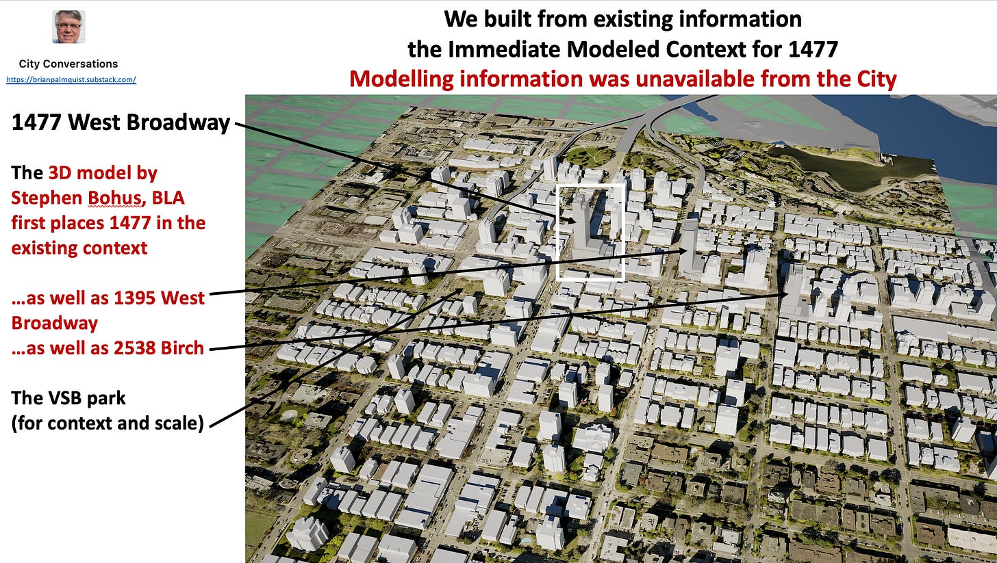
Figure 6 – How we built the Broadway Plan Model, Part 2
In Figure 6, this build out of existing buildings around 1477 includes the recently approved 2538 Birch project as well as the 1395 West Broadway project currently under consideration by Planning.
It wasn’t until I saw this model that I realized the only green space in this area is the Vancouver School Board’s “back yard” at Fir and 10th.
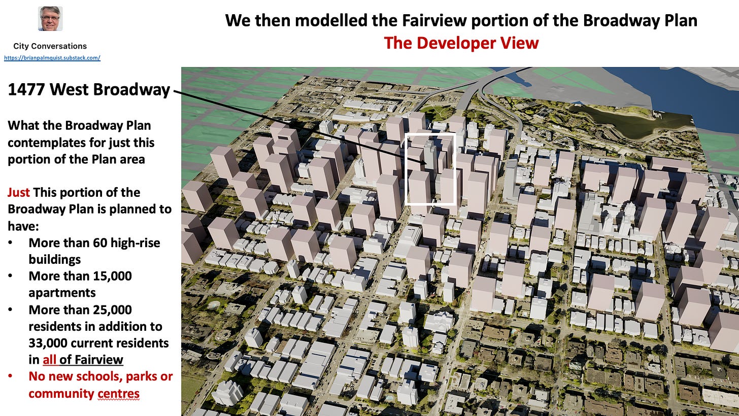
We next modelled in Figure 7 what the proposed Broadway Plan would permit in this area—I call this the Developer View.
What this shows includes:
- More than 60 high-rise buildings in the study area from Burrard to Alder, 7th to 12th , ranging from 20 to 40 storeys;
- 15,000 new apartments in addition to 1477’s 200+.
This equates to an additional 25,000 new residents in this area, as compared to a current total population of about 33,000 in all of Fairview. That’s about 1,000 new residents in each of the study area’s residential blocks.
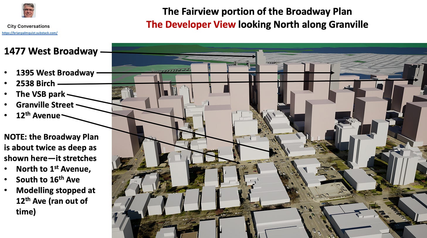
Figure 8 is the view from about 40 storeys in the air, looking north up Granville Street. The North-South extent of the Broadway Plan is actually twice what’s shown here but we stopped modelling at 12th Avenue because we ran out of time.
The VSB’s back yard is still in the picture, but now shaded most of the time by new high-rise buildings permitted on the south side of 10th at Fir Street.
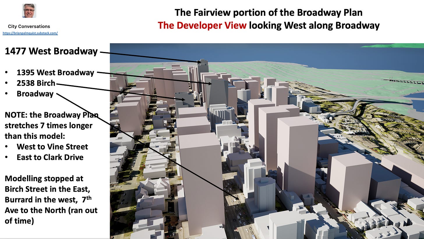
Figure 9 – An aerial view along Broadway — but we are assured there will be no shadows
Figure 9 looks west along Broadway and includes 1477 Broadway as well as other buildings permitted by the Broadway Plan. Time pressures limited our study area to only about 1/7th of the length of the Broadway Plan area from Clark Drive to Vine Street.
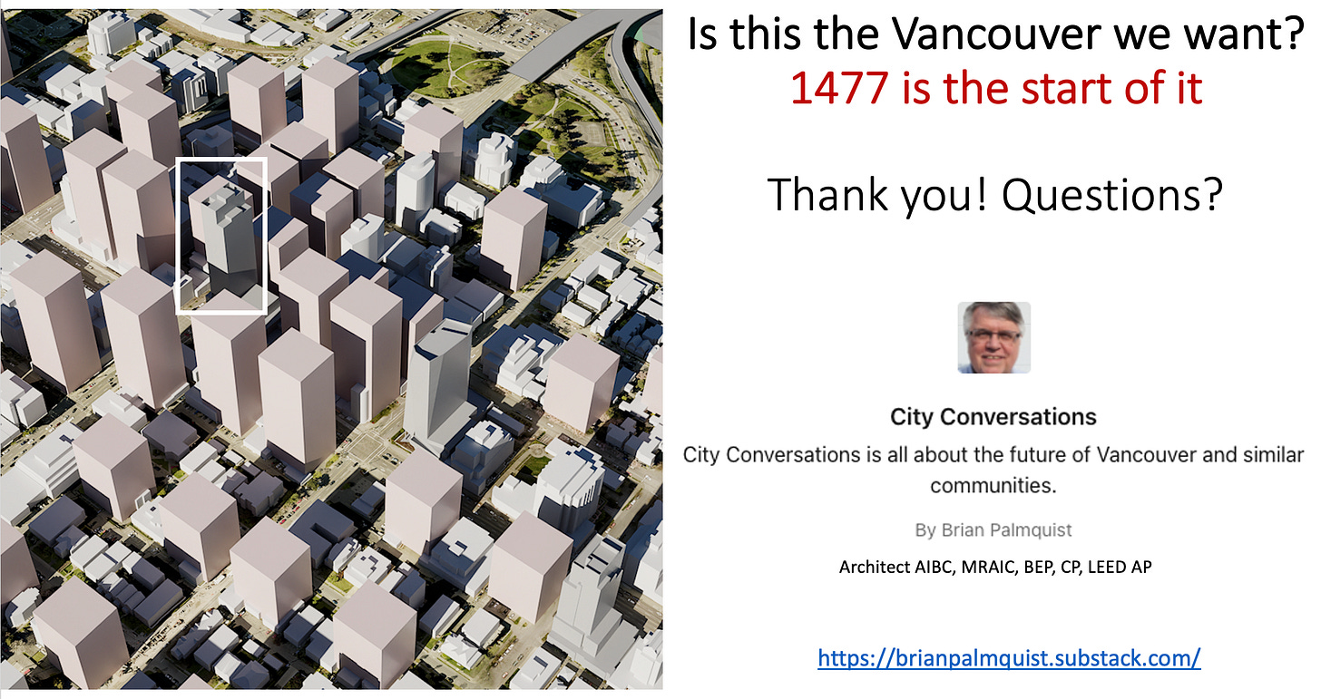
Figure 10 – 1477 West Broadway in its context — Is this the Vancouver we want?
Hopefully this brief presentation leaves Council with some things to think about:
Our modelled study area is only about 1/12th of the Broadway Plan’s total area, yet contains up to half of the totals for the entire Broadway Plan area—the city’s numbers just don’t add up.
We’ve not had time to model in 3D the balance of the Broadway Plan area, but we have done the analysis to inform that modelling:
- The entire Broadway Plan will actually accommodate more than 100,000 new apartments, NOT the 30,000 mentioned in the Planners’ “vision” for this large area of the city. That 30,000 is mentioned as an aspiration, not a cap or limit, which is worrisome
- The true capacity of the Broadway Plan will accommodate ALL of Vancouver’s projected population growth over the next 30 years. BUT there’s already a 30-year supply of homes spot rezoned throughout the city, in virtually every neighbourhood, mostly not yet built.
- We ALSO have an additional 10-year supply of housing in recently introduced projects such as the Jericho Lands and Senakw.’
So 1477 is the high-rise beach head for a mostly high-rise 70-year supply of spot-rezoned housing, not including incremental development, laneway housing, duplexes, etc., that is consistent with the city’s already existing zoning.
Is 1477 the model for the Vancouver we want?
Brian Palmquist is a Vancouver-based architect, building envelope and building code consultant and LEED Accredited Professional (the first green building system). He is semi-retired for the moment, still teaching and writing, so not beholden to any client or city hall. These conversations mix real discussion with research and observations based on a 40+ year career including the planning, design and construction of almost every type and scale of project. He is the author of the Amazon best seller “ He is also a member of TEAM for a livable Vancouver, a new political party dedicated to restoring a livable Vancouver starting with the 2022 civic election. City Conversations are generally congruent with TEAM policy, so if you like the ideas that I’m writing about, please consider joining TEAM.