

Sea Level Rise is too big of an issue to ignore, or say “Oh, we’ll be okay.”
The December 2021 Draft Gateway Area Plan has one mention of Sea Level Rise.
“New growth and new development come with an environmental cost. More people typically means more energy use, more cars, more waste generation, and more greenhouse gas emissions. As the climate warms due to human activities, the next generation of Arcatans will face challenges at a scale that no generation has previously faced. As an example, sea level rise will displace local residents, furthering other challenges listed above. Such displacement will exacerbate the housing shortages, will intensify market demands, and put remarkable pressures on critical infrastructure. These types of challenges need to be actively acknowledged and mitigated as the community plans for growth in the Gateway Area. This includes prioritizing non-motorized transportation, electric vehicle charging infrastructure, and green buildings. This also means that the City must find ways to reduce greenhouse gas emissions while simultaneously adding population and new buildings.” Page 19
What’s wrong with that statement?
“These types of challenges need to be actively acknowledged and mitigated ….” No, we do not “mitigate” Sea Level Rise by “prioritizing non-motorized transportation, electric vehicle charging infrastructure, and green buildings.” Oh, that is good stuff to do — no issues on that. But that is a far cry from mitigating the problem.
There is no inkling of a suggestion that anything is in this Gateway plan about the very real issue facing Arcata — the actual rise of the sea.
The images below will do for a start. Here are two of many factors that are applicable here:
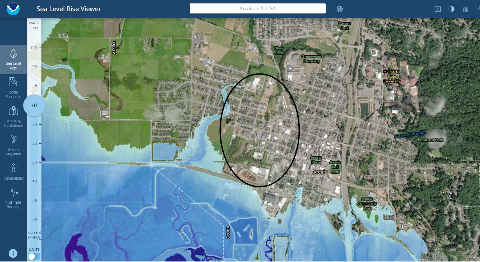
- How quickly Sea Level Rise will occur. Currently it’s predicted about 7 feet by 2100, around 80 years from now. But every prediction from the past had to be revised upward — and the real answer is that we don’t know. This does not mean that we need to put our lives on hold; just that any plans may be better off looking not just at the current predictions but also at the history of these predictions.
- King Tides and Storms. The images below are for “Current Mean Higher High Water” projected figures. Included is an image of the King Tide flooding at the current time. It adds about 2 feet (roughly) to the Mean High Water mark maps. If there is a storm at the time of the King Tide and if there are winds — as we certainly have had here — then that pushes the height of the water still farther. Anyone who has lived around Arcata a while knows of what Winter storms can do. There’s been flooding in Westwood on the east side of Alliance, in the Greenview neighborhood, in what is now Windsong, and elsewhere. Highway 101 has been covered with water. Paddling a canoe on the waters covering city streets is not a myth — it’s happened already.
The City of Arcata’s Frequently Asked Questions page for the Gateway plan has this:
Q: IS THE GATEWAY AREA PROJECTED TO BE IMPACTED BY SEA LEVEL RISE?
A: The Gateway Area is not modeled to be impacted by rising sea levels until nine feet of sea level rise occurs, which is 80 years into the future at the “Extreme” modeling scenario. Per the “Intermediate High” scenario, the site is not modeled to be impacted by SLR until well after the year 2100. Even then, SLR impacts would only reach very minor areas along the very southern edge of the Gateway Area and then only during high tides. The vast majority of the Gateway Area is well outside of all SLR model predictions, with elevations exceeding 20 feet in most of the district. Note that the SLR projections assume the City will do nothing to address flooding associated with SLR. Accordingly, if the projections prove to occur as modeled, then measures adopted by the City in the future to manage storm and tidal waters will extend the timelines.
Comments:
- Why not say what the elevation is it the lowest areas instead of “exceeding 20 feet in most of the district” ? Wouldn’t that be a more honest way of discussing the issue?
- What if the predictions, say, are off by a factor of 2? What if it were that 9 feet rise — at mean sea level, not King Tides or floods — occurred in 40 years?
- In the case of a big storm coinciding with a King Tide — What happens?
On Google Earth the elevations shown are approximate. That site indicates an elevation on the south (bay) side of Samoa Boulevard at 7 or 8 feet, and the elevation on the north side, at 11 or 12 feet. That’s where the industrial site is in the Gateway area, where 1,300 apartment units are intended to be located.
Perhaps someone who’s an expert can help out here. We’ve already seen flooding up to Samoa Boulevard. It sure seems that if there is already Winter flooding in an area that’s 7 or 8 feet in elevation, then it won’t be too long before there’s flooding at 11 or 12 feet. It won’t be anything like 80 years.
Here are images taken from the Sea Level Rise Viewer from NOAA (National Oceanic and Atmospheric Administration). Link is here for Arcata. Or to start fresh, here.
The oval is approximately where the Gateway area is located.


