

Comments submitted on the
Gateway Area Code document
Public Review Draft
Dated: January 31, 2024
Also known as the form-based code for the Gateway Area Plan
The “Public Review Draft” of the Gateway Area Code can be viewed here.
by Fred Weis
April 18, 2024
Councilmembers, Commissioners, and members of our Community:
This is a lengthy document. For a simplified guide on how to view topics in areas that may be important to you, please see Guides for the Council, Commission, and Community — to the Gateway Code comments and suggestions.
This document contains a Table of Contents.
Every bulleted item on this Table of Contents should have a response, even if the response is “Decline to comment.” Every item in this document is here for a reason.
To the Reader:
Scan through the Table of Contents. Pick out the topics that are of interest to you.
Then, read through those sections first.
Topics in this document that may call to you
- Do we want to see hotels in the Gateway area?
- A form-based code does not prevent bad design. If the Planning Commission wants or does not want certain styles of design, the Gateway Code has to be specific.
- No mention of the L Street corridor linear park. The Code treats “L Street” the same as an ordinary street.
- Park in-lieu fees should be kept in the Gateway area.
- Graduated stepbacks are required to allow light into Public Open Spaces.
- Pedestrian realm dimensions are in conflict with setback dimensions.
- Unbundling parking for tenants and employees — Clarify reasonable ranges of in-lieu fees.
- Vehicle roads in the Barrel District.
And more.
Page numbers for the Gateway Code document
It is requested that page numbers be added to the Sections list table of contents of the Gateway Code document. This is a small addition that would be helpful to the reader. The Gateway Area Plan (94 pages total) has a table of contents with actual page numbers. This Gateway Code document should also. Below are the page numbers for each section.
It is also requested that the subsection name and number be placed in the header on each page. Currently pages 2 through 64 show the chapter number of 9.29. While this is factually correct, it is not helpful to the reader. Better would be a heading with, for example “9.29.070 – Streetscape.” Or, if not appropriate to place in the header, then to add to the centered page number in the footer.
Sections:
9.29.010 – Introduction …………………………………………. 1
9.29.020 – Permits and Approvals …………………………….. 4
9.29.030 – Allowed Uses ……………………………………….. 10
9.29.040 – District Standards …………………………………. 11
9.29.050 – Supplemental to Districts ………………………… 24
9.29.060 – Building Design Standards ……………………….. 31
9.29.070 – Streetscape …………………………………………. 45
9.29.080 – Mobility ………………………………………………. 48
9.29.090 – Open Space …………………………………………. 55
9.29.100 – Community Benefits………………………………… 61
Table of Contents
Tap or click on any topic here to go directly to that topic in the article.
You can use your browser’s back button or backswipe to return to this Table of Contents.
-
- How to use this document
- Some history … and why this document exists
- Planning Commission and public review of this “Public Review Draft”
- Have local architects been involved with the development of this Gateway Code?
- The timeline and budget for the Gateway Code
- There’s an awful lot of sloppy work in this document
- Approval by the Council
- Recommended additional material to read or view
Major Topics
-
- No mention of the L Street corridor linear park. The Code treats “L Street” the same as an ordinary street.
- The L Street corridor Linear Park will need its own clarifying policies.
- Graduated stepbacks would let more light into Public Open Spaces.
- Graduated stepbacks are better than doing nothing – but there are better solutions. Ideally we should not have block-long buildings next to the linear park.
With sketches from Martha Jain - 3D images are not in compliance with the Gateway Code and/or Gateway Area Plan.
- Pedestrian realm dimensions are in conflict with setback dimensions.
- Why is the space for non-active frontages larger than the space for active frontages?.
- Awnings and building entrance coverings will extend beyond the building’s private frontage zone and into the sidewalk area.
- Pedestrian realm dimensions require discussion and possible revision.
- General questions, to achieve greater clarity in the document
Errors and questions that must be addressed.
Planning Commissioners:
Suggested for further review
-
-
- Folding security gates (Scissors gates) are permitted in the Gateway area.
- Shared Garages facing street frontage
- Glazing requirements for non-residential transparency
- Greenways – Requires discussion on locations and practicality Important
- Barrel District “Community Square” ownership
- Barrel District “Community Square” lighting
- Barrel District master plan
- Question of “street” setback for buildings alongside the L Street corridor linear park, and along greenways and woonerfs
- Gateway Prohibited Uses
- Periodic Planning Commission Review
- Commercial uses within the Gateway area: 25,000 to 40,000 square feet
- Do we want to see hotels in the Gateway area?
- Environmental Review – Contaminated sites in the Gateway area
- The “Gateway Use Permit Requirements” allows Zoning Administrator review if new uses are under 25 units per acre
- Mechanical equipment not facing street frontage, even if enclosed by a fence
- Consider the required locations of Active Building Frontage types
- “Limit motorized vehicle traffic to no more than two sides of the square.”
- Park in-lieu fees should be kept in the Gateway area
- Privately-owned Publicly-accessible Open Space, parks, and parklets – a critique.
- Privately-owned publicly-accessible spaces – Other issues.
- Unbundling parking for tenants and employees — Clarify reasonable ranges of in-lieu fees.
- “A linear park is required within the N Street right-of-way north of 11th Street.”
- N Street bikeway for commuting and L Street bikepath for ambling
- Site Design for 10th & N Streets – Connect this to the Creamery
- Fences around parking lots facing a street?
- Is a parking garage allowed in the Gateway Area?
- Shadow Mitigation is part of Arcata’s Land Use Code. This should be made more clear in the Gateway Code. 55
- Parking Structures to feature a façade with the appearance of habitable uses. 58
- Enhanced Upper-Story Stepback Requirement locations – Maps and suggestions
- Enhanced Upper-Story Stepback requirement locations, and suggestions for improvements
- Complete-block parcels require a new alley?
- Bike Parking Spaces Required
- Other bicycle parking issues
- Community Benefits Program is not described correctly
- Carpools and Vanpools require 0 or 1 parking space – Pointless
- Trim and Shutters should not be counted toward window glazing requirements
- List of options for façade articulation needs to be looked at
- Material Durability – Timber Protection
- No standards for electric vehicle charging or community gardens
- No standards for bus-stop pullouts
-
Fred Weis:
Comments, suggestions, and requests
-
- Does this draft Gateway Code contain all that the Planning Commissioners have asked for?
- An Administrative hearing may be continued only one time – and a decision must be issued
- As this is a form-based code, it would be useful to have the definitions of the terms use shown as diagrams
- The quality of the isometric Building Massing figures could be improved
- A form-based code does not prevent bad design. If the Planning Commission wants or does not want certain styles of design, the Gateway Code has to be specific.
A bad design for the AmeriGas site, as an example. - The effects of Zero setbacks and a disregard for homes on adjoining properties
- Roof projections above height limit
- Vehicle roads in the Barrel District – Important
- A proposal for the Barrel District circulation – Important
- Minor typographical and editing errors.
- Minor typographical and editing errors.
Preface
To the reader: What follows is informative, but please do not get bogged down here. The suggestions and corrections to the Gateway Code is what is important.
How to use this document
To Arcata’s Planning Commissioners, City Council members, and interested members of the Public:
I wrote this document so that we could have a better Gateway Code. The Gateway Code defines the “look and feel” — and more — of the streets and buildings in the Gateway area.
The intention is not that you will agree with all of what is presented here. But it should be brought up and discussed – and to this point most of what’s here has not been discussed.
This document has seven sections:
-
- Preface
- Major Topics
- Errors and questions that must be addressed
(Includes typographic errors, improper definitions, bad or wrong diagrams, numeric errors, and other issues that are confusing or misleading or counter to the intents of the Gateway Code.) - Planning Commissioners: Suggested for further review
- Fred Weis: Comments, suggestions, and requests
- Minor typographical and editing errors
- Appendix
It is not necessary to read this entire document. The titles of the topics in the Table of Contents are intended to give the reader a summary of what that topic is about. The topics are not listed in any particular order. Many are grouped together, but not all.
Suggestion: Scan the table of contents and pick out those topics that are of interest to you.
In the on-line version of this document, the Table of Contents will link you directly to that topic. The link to the on-line version will be found at arcata1.com/gateway-general-plan-other-documents/#gateway-code
Where there are refences to a table or figure or map, I generally included that graphic so that the referenced information would be in one place and you would not have to refer to the Gateway Code or other document to find it.
Suggestion: After identifying the topics of interest, print out that section of the Gateway Code document, so you can read it and take notes. Or, print out the entire Gateway Code document (64 pages, including cover). The Public Review Draft Gateway Code PDF can be printed from the Arcata1.com article here or from the City of Arcata’s SIRP webpage: www.cityofarcata.org/896/Strategic-Infill-Redevelopment-Program
If I am factually incorrect on anything I’ve written here, I want to know about that. I apologize for any errors. Please contact me so I can correct the error. If there are ideas presented here that you’d like to discuss, please contact me. E-mail is Fred at Arcata1.com. Possibly we can set up a Q&A session at a Planning Commission meeting.
Suggestion: Start with the “Errors and questions that must be addressed” section. Many of these errors/questions can be fixed without much discussion. Some are obvious typographical errors. In others the Planning Commissioners’ intentions can be clarified quickly.
Some history … and why this document exists
I prepared this document at the suggestion of David Loya, Arcata’s Community Development Director. Of course, I wanted to write this all out and put it in one place too.
The 2nd draft of the Gateway Code came out September 22, 2023. This current “public review” draft version, the 3rd draft, is marked January 31, 2024, and is considered as the February, 2024, draft. The June 2023 first draft was announced by the City via their listserv e-mail. I do not believe drafts #2 or #3 were announced.
Two days after the 2nd draft was released, I wrote an article that outlined what the differences were between the first draft and the second draft, and noted some it items in that 2nd draft that need to be looked at. This article is in the Appendix, below. It is included here because: From all that is expressed in that September 24, 2023, article, not a single item was addressed in the 3rd draft, the “Public Review” draft. The 3rd draft, the “Public Review” draft, contains the same typos and the same errors as the 2nd draft, the same omissions of important material. Nothing changed.
The current February 2024 draft contains the 3D massing plans that had been contracted for in December 2022, 13 months earlier. (It would have been helpful to the community and the Commission to have had those 3D images much earlier.) As far as I know, there were no changes to the text or the images in the current 3rd draft, other than those 3D diagrams. All the typos and form-based code errors that were in the 2nd draft are also in the 3rd draft.
I’ll repeat: There were no other changes from the 2nd to the 3rd draft – zero. Just those 3D images on the cover and on pages 2 and 3.
Planning Commission and public review of this “Public Review Draft”
Despite being asked on many occasions when the Planning Commission review of this “Public Review Draft” of the Gateway Code would take place, the Community Development Director and the Planning Commission would not respond. Having advance notice of when the Gateway Code discussion would occur would allow the public to better prepare their comments.
At the current time (April 18, 2024), there is still not an official word as to when the Commissioners will address this Public Review draft. [Update: The Planning Commission will be discussion the Gateway Code at their April 23, 2024, meeting.] What we do know is that the Commission meeting on May 14, 2024, will include a public hearing on the General Plan Update, including the Gateway Area Plan and the Gateway Code — 454 total pages of documents.
In theory, the Gateway Code will need to be discussed prior to that May 14 meeting. That would mean that the Planning Commission will discuss the Gateway Code at their next meeting, on Tuesday, April 23, 2024. But that information has not yet been disclosed, and will not be until tomorrow, Friday afternoon, April 19.
Have local architects been involved with the development of this Gateway Code?
If so, which ones? Their names and their comments would be of great value to us. If not, I would them to see this document for their comments – and have the comments included in a public form.
There was a by-invitation-only meeting between the Community Development Director and a group of five or six (I believe) local registered architects or home designers. This took place in the Summer or Fall of 2022 – well before this Gateway Code was written.
I have been in communication with two of those who were present. Both felt that the meeting was, essentially, a waste of their time. “In the room were some of the most well informed and experienced design professionals in Humboldt County. Sadly there was not enough time for us to explore ideas and solutions. I was sad and a little frustrated that so much talent was wasted. We might have been able to come up with some specific proposals that would have alleviated fears that we will end up with a paint-by-numbers approach. It felt like there was a need to check off a meeting with architects but no real interest in any ideas.”
The timeline and budget for the Gateway Code
The first version of the Gateway Code (the form-based code) came out in June, 2023. Based on Arcata’s contract for this work with Planwest, the “Public Review” draft of the form-based code was to have been released at the same time as the first draft Gateway Area Plan, originally scheduled for August 2021 and actually released in December 2021. The “Public Review Draft” of the Gateway Code came out on January 31, 2024 – three years after originally scheduled.
We can overlook that this took so much longer than originally planned. It seems that there were a lot of Planwest people who did not understand what would be required. The goal is to have a good Gateway Code.
The original contract with Planwest was both overly ambitious and also with little comprehension of what would be involved in getting this Gateway Code done. The original budget of $16,830 was meant to cover the development of the form-based code. This was expanded to include community outreach, polling, results of the polling, a town-hall meeting on the Gateway Code, enhanced graphics, and “site testing” to determine the value and feasibility of what could be built, 3D “plan area massing diagram,” and more. The new budget was $134,704 – eight times the original amount. This increase was approved by the City Council at their December 21, 2022, meeting.
Of the $118,000 requested by the Community Development Director and approved by the City Council on December 21, 2022, it is my view that about 30% of the funding has vanished. That is, funds that were allocated for specific purposes, and nothing (or not much) was delivered. This could be analyzed more thoroughly if requested.
There’s an awful lot of sloppy work in this document
The Gateway Code document gives the appearance of not having been carefully read through. There are sections that appear to have had been copy-and-pasted from another source, without checking the actual words or figures. Certain diagrams that are meant to illustrate specific dimensions may show the distances incorrectly, and do not illustrate what they are suppose to show.
There are at least a dozen typographical errors, bad figures or tables, and so forth in this document that actually would affect how a developer could read and follow what’s here. I’m not talking about ordinary misspellings – I’m talking about where it says “750 feet” and it likely means “75 feet.”
There is the blatant disregard for the L Street corridor linear park. It is on no map; there is no accommodation for it; there is not one word mentioned on it. This Gateway Code refers to “L Street” as an ordinary road. The determination on the L Street corridor linear park was established by the City Council eight months ago.
It was not my intention to compile a document as long as this. But the more I looked at the Gateway Code, the more problems I saw, and the worse it looked.
The document does not appear to have had a thorough reading-through, or basic proof-reading. At first glance, the document looks okay. But there are just too many errors. A person who truly had read this document for content would have spotted the errors and omissions. I don’t mean to be judgmental, but that is how I see it.
Approval by the Council
As we are aware, the City Council has two members who must recuse themselves from discussions and votes on the Gateway Area Plan because of the California Fair Political Practices Commission rulings on conflict-of-interest issues. As a result, the contents of this Gateway Code will be voted on by three Council members. In order to establish a three-out-of-five majority, the votes of the three Council members must be unanimous.
It is in everyone’s interest to have this Gateway Code be as complete and accurate as possible.
This document should not, through its own errors, provide a reason for its rejection.
Recommended additional material to read or view
- Articles and workshops on Form-Based Code
On Arcata1.com: arcata1.com/gateway-general-plan-other-documents/#gateway-code - Gateway Density and Feasibility Study – Gateway Code Site Tests
Presented by Ryan Call of Urban Field Studio to the Arcata Planning Commission, July 11, 2023. All articles and critique on the Urban Field Studio report and presentation can be seen here. The presentation itself is here.-
- At their December 12, 2022, meeting, about one year after the Gateway Area Plan had been released to the public, the three-person allocated additional funding for the Gateway Code. Included in the $118,000 supplemental funding was $13,600 for what is called “site testing” for four sites. This would be, to quote from the proposal, “to test the proposed code standards on four opportunity sites, one in each district. Testing will confirm that the proposed standards can feasibly accommodate the desire type and intensity of development.”
As it was, the tests were a disappointment and a sham. The study does conclude that the Gateway Plan will “facilitate high-density residential development” — but we already knew that. That much could have been concluded in five minutes with some calculations on a scrap of paper.
The study was supposed to be on four sites, in four different districts. As it was, there were three test sites in the Corridor District – the car wash site, the AmeriGas site, and the St. Vinnie’s site. The St. Vinnie’s site was erroneously identified in the study as being in the Neighborhood district. In the 138-acre Gateway area, all four sites were within two or three blocks of each other. Each site had frontage on L Street or K Street or both. In other words, this was not a representative sample of possible Gateway Sites.
The fourth site was the Tomas / Open Door Clinic office building. This is at the very northeast corner of the Barrel district – not at all related to the industrial area of the Barrel District. It is across the street from The Pub and the Creamery block, and across the street from the Corridor site.
The authors of the study seem to have missed the point of what we are trying to do here in the Gateway Area Plan and in Arcata in general.
The conclusions reached in all four designs is that they would not be economically feasible to build.
- At their December 12, 2022, meeting, about one year after the Gateway Area Plan had been released to the public, the three-person allocated additional funding for the Gateway Code. Included in the $118,000 supplemental funding was $13,600 for what is called “site testing” for four sites. This would be, to quote from the proposal, “to test the proposed code standards on four opportunity sites, one in each district. Testing will confirm that the proposed standards can feasibly accommodate the desire type and intensity of development.”
-
- The design for the car wash site does not do any additional daylighting on Jolly Giant Creek, as called for.
- “The narrow sidewalks and the narrow setbacks actually bring people together in a way that you can’t really avoid each other, which I think is actually a really good thing for a community.”
- In the analysis of the Tomas/Open Door Clinic site, it seems the authors didn’t have a clue that the Creamery businesses and The Pub were so close. For the authors, everything was based on the distance from downtown, even though the aim is to build a “vibrant community” right there in the Gateway area. Quotes: “Ground level retail is very far from the retail district. It is possible it would remain vacant or suffer from turn-over.” “The ground level retail I think, is just a little too far from your city core.”
- The test site designs were based on “structured parking” – one or two stories of parking garages in a concrete structure that residential floors are built on top of. In every case, the verdict was that the buildings designed for this test site report would likely be unfeasible to build.
“The structured parking is expensive, which may require higher rents or luxury units to help cover those costs, if it’s feasible at all.” - The test site designs show no privately-owned publicly-accessible open space – even though that is required by code (or in-lieu fees paid).
The 11-page written report; audio and videos 25-minute presentation and questions and responses from the Planning Commissioners and the public; transcriptions of the presentation and the Commissioners’ comments are all on Arcata1.com. (arcata1.com/gateway-general-plan-other-documents/#gateway-code and scroll down a few rows.) Also, a video of oral comments (a few minutes) from that presentation meeting, and a further article of critique of this test site report.
-
- My conclusion: The study should be redone, or Arcata’s money should be refunded. The report was full of untrue assumptions. The promoted designs were acknowledged as being unfeasible. The authors did not appear to understand the nature of Arcata, the goals of the Gateway Area Plan, or the geography of the Creamery district.
- Commissioners are encouraged to view the 194-page (very dense pages) form-based code Redwood City Downtown Precise Plan, originally from 2011. It can be viewed at arcata1.com/redwood-city-downtown-precise-plan-html or at the Redwood City website. For what is essentially a technical document, it has become a highly-viewed article on Arcata1.com, with other 1,100 views. Looking at this document for even five minutes will show what a well-crafted form-based code document can look like.
I don’t mean to compare the Arcata Gateway Code with what Redwood City put out – they had vastly greater personnel, resources, and money to make their plan. Although Arcata’s form-based code is smaller and simpler, it does not show the care and thoughtfulness that the Redwood City plan shows.
- Marin County Form-Based Code. 322 pages. December, 2022.
This is beautifully-crafted document, with hundreds of diagrams that illustrate the text of the form-based code. This document is essentially for Building Design standards only – not for streetscape, circulation, uses, permitting, open space, community benefits, etc. Again, an obviously higher-dollar document than Arcata’s Gateway Code, yet fun to look at and view their approach. (Cost was $1.14 million, paid with grand funding, and for the county and 10 cities in Marin.) Not to be compared to Arcata’s Gateway Code.Created by the Berkeley-based urban design/architect firm Opticos (opticosdesign.com). For their Form-Based Code projects, see: opticosdesign.com/work/?tag=form-based-coding
“Opticos was founded in 2000 on the belief that walkable places are critical for healthy, resilient and equitable communities. Through that expertise, we introduced the concept of Missing Middle Housing, a transformative idea that highlights the need for diverse, affordable housing options in walkable urban places. In addition, we are leaders in the development of Form-Based Coding, zoning reform needed to make those walkable places a reality. Through our work, we are changing cities, communities and lives.”
- Building and Massing videos by David Loya
The video chapters of “Building and Massing” were produced by Community Development Director David Loya and released in August, 2022. If any Commissioners have not viewed this 5-part series, it is very worthwhile to see at least the first four videos. In total, it is 47 minutes. [Note: The contents of the “5: Financial Feasibility of Development” are not valuable, in my view.]
For the first time we saw how the 3D modeling can aid us in envisioning just what construction in the Gateway area might look like. Unfortunately, not much happened with 3D modeling until this past January, when the Gateway Code came out – a gap of over 16 months. The video contains a 3D image rendering of potential design for the Car Wash site by local architect Julian Berg, with full creek daylighting. It was displayed in color in the video for only a second or two, but is captured as still image on Arcata1.com. See: arcata1.com/3d-images-and-aerial-views
Because of the value of the Building and Massing videos, I took the time to make a transcription of the whole, and set up webpages where you can read and view the video at the same time. Or just watch the video. The intro to the series can be found at arcata1.com/building-massing-presentation-videos-august-12-2022 with instructions and links on how to view each of the five sections. (Note: Most of it has
value. Some does not.) - The Myth of “Privately-Owned Publicly-Accessible” Open Spaces
Article on Arcata1.com. arcata1.com/the-myth-of-privately-owned-publicly-accessible-open-spaces
Major Topics
- No mention of the L Street corridor linear park. The Code treats “L Street” the same as an ordinary street.
- The designation “L Street” is in text in the document four times and is shown in images seven times. There is no “L Street” in the Gateway Area. At the August 22, 2023, Council / Planning Commission joint study session, the Council made this determination: The L Street corridor will contain a full-width linear park.
- “L Street” is in this draft Gateway Code document on pages 16, 19, 52 (two times) in text; on pages Cover, 2, 3, 25, 27, 29, 49 on maps or images.
- The Council decision was on August 22, 2023. This draft Gateway Code document is dated January 31, 2024. That is five full months. The draft is expected to come before the Planning Commission on April 23, 2024. That is eight full months. There has been no change to the draft Gateway code during this time that reflects the existence of the L Street corridor full-width linear park in the Gateway area.
- The map of “Conceptual Greenway Location” on page 49 does not show the L Street corridor full-width linear park.
- The map of “Enhanced Stepback Required” on page 27 shows enhanced stepbacks as being required on L Street corridor for one block only, on the east side between 8th and 9th Streets (across the street from the Creamery and the Pub).
- The Gateway Code makes reference to Figure 8 of the Gateway Area Plan (GAP), the Proposed Vehicular Circulation map. That map is dated 12/19/2023 — four months after the Council’s linear park determination – and does not show the proposed L Street corridor linear park. (We can note that the date on the map – 12/19/2023 – is after the date on the cover of the current latest GAP, V14a.2, shown as 12/12/2023.)
- There is no mention in this draft Gateway Code of protection from solar shading onto the L Street corridor linear park. As it stands, four, five, six, and seven-story buildings can be built directly adjacent to the linear park.
- A building could be placed perhaps right on the property line, perhaps 10 feet inside of the property line, perhaps 15 feet inside of the property — depending on the readers’ interpretation of the code. The Planning Commission needs to clarify this.
- Question of “street” setback for buildings alongside the L Street corridor linear park. Each district has a table with specifications for setbacks from the property line for building placement abutting a street, abutting an enhanced setting, from side property lines and from rear property lines, or from all other property lines. For the Hub, Barrel, and Corridor districts, there is no setback requirement for other property lines.
The question is this: The L Street corridor is no longer a street. It is the location of a full-width linear park. As such, it is not a street, and therefore the “other property lines” minimum setback requirement would be used. That is: Zero feet, no setback. Since it’s not a street, there would not be a requirement for sidewalks either.
- Graduated stepbacks to allow light into Public Open Spaces
As the Gateway Code is currently, construction of four, five, six, and seven-story buildings can occur adjacent to the L Street corridor full-width linear park. These buildings may be required to be setback 10 feet from the property line along the linear park, or possibly may be allowed to be built right up to the property line. There is no requirement that these buildings have an upper-story stepback on what would be a rear wall of the building, as upper-story stepbacks and upper-story mass reduction is described as percentages and not specified to be on a set side of the building. A such, there can be a vertical wall with no interruptions at a height of 50, 60, 70, or 80 feet high, depending on the district.
The result could be to turn the linear park into a “canyon-like” passage. Below is an image of how this possibility could look, based upon the current Gateway Code. This and more can be seen at arcata1.com/gateway-code-along-l-street
Because of the north-south direction of the linear park, at the height of Summer this would result in the linear park being in full shadow for all but four hours of a 15-hour-long Summer day. For all but two hours of the day, at least half of the park would be in shadow. This is at the best time of the year. In Winter, the amount of sun or shadow is about half of that.

A new set of polices needs to be discussed and adopted. Some suggestions:
- Define what a woonerf is, for Arcata.
- There are some sections of the corridor where there are existing driveways, garages, and entrances to parking lots. I count 3-1/2 blocks of the 10-block length of the corridor that will need this type of vehicle access.
Suggestion: Have two types of woonerfs – one for regular daily vehicular traffic (probably won’t exceed 40 car trips a day), and a different type for what is expected to be only delivery and emergency vehicles. The first type would be in active use, with people going to their homes.
- Define the types of construction and types of businesses that that would be allowed. Determine how to encourage those businesses to locate there.
- More, to be discussed.
The Planning Commission may wish to discuss and incorporate this design feature into the Gateway Code.
The intent is to provide adequate “blue sky” vision in a public open space. The image below shows a multi-story building next to an existing historic resource structure. The same policy applies for a building to be built adjacent to a pubic open space.
Below is from the Redwood City municipal Zoning Code. The Upper-Story Stepback of a 45-degree daylight plane is required for buildings next to a public open space or an historic structure.
“Upper-Story Stepback. Buildings shall not intercept a 45-degree daylight plane inclined inward from fifteen (15) feet above existing grade at the property line of the parcel adjacent to property line of an adjacent property containing public open space or an historic resource.”

- Graduated stepbacks are better than doing nothing – but there are better solutions. Ideally we should not have block-long buildings next to the linear park.
Arcata’s Winter sun is lower in the sky – even at Noon – than the angle of a 45-degree graduated stepback. A graduated stepback design is far better than a blocky rectangular building with only an 8-foot stepback on the 5th floor, but there are other considerations that would make for a better design.
As the sun moves across the sky, the degree of shading will be based on the shape of the building and its orientation to the sun.
For a 28-second video of the effect of solar shading on a section of the L Street corridor linear park, see the article “Solar Shading Impacts – video and still images” : arcata1.com/solar-shading-impacts-video-still-images/#linear-park
If 5-story buildings are allowed to be built on both sides of the linear park, the park will be shadow for all but a few hours a day, even in the Summer.
Arcata architect Martha Jain made some sketches that illustrate this issue.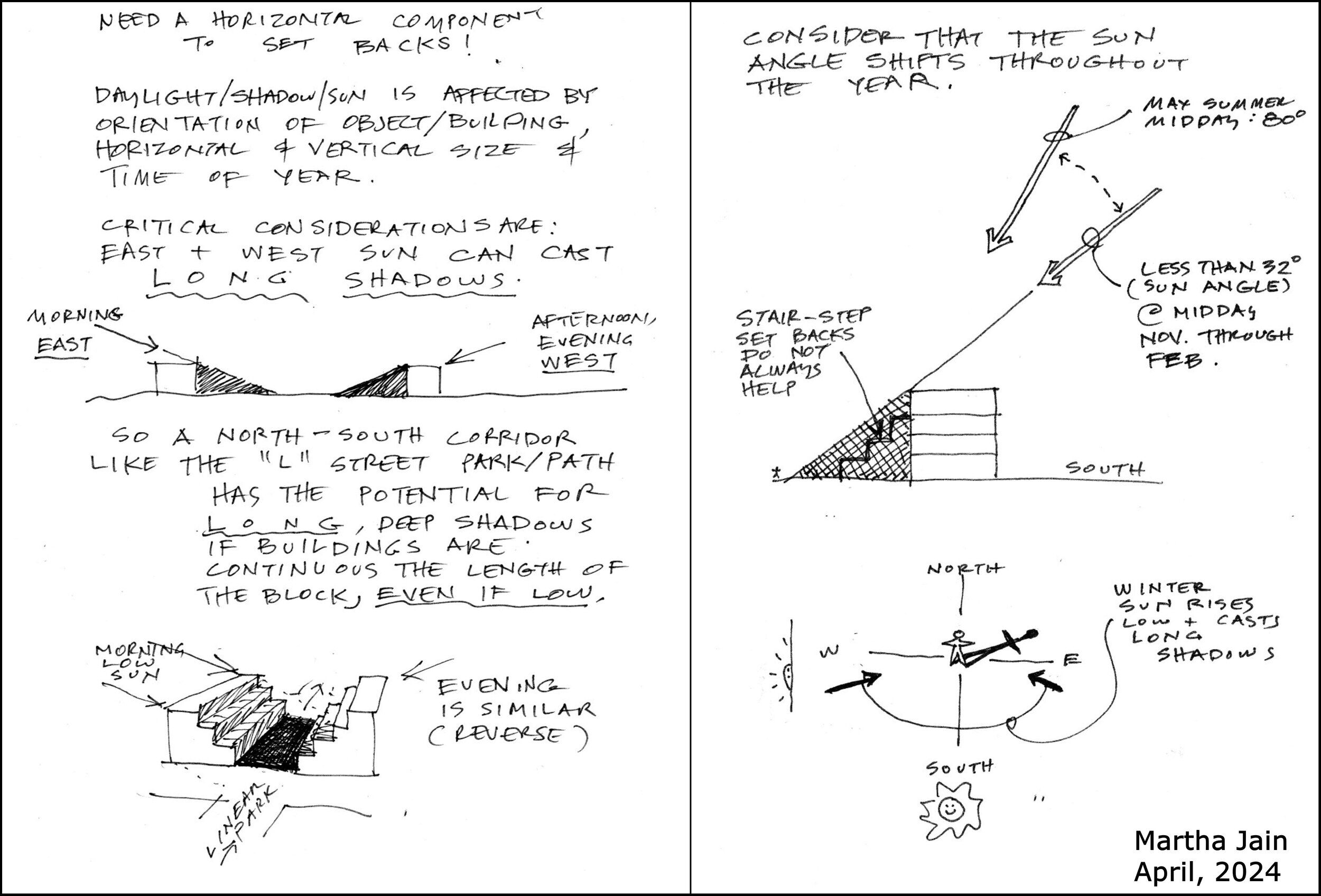
- 3D images are not in compliance with the Gateway Code and/or Gateway Area Plan
- Images do not show the L Street linear park.
- Images show “L Street” — there is no “L Street” as the street has been replaced with a linear park.
- Barrel District shows a road that is excess of 300′ between an intersecting street. The westernmost section appears to be about 900-950 feet.
- Sample building shown at the Car Wash site does not show the creek being daylighted. (This site is the block between K and L, between 9th and 10th.)
- While the Gateway Code and the Gateway Area Plan minimizes the use of parking lots, in these 3D images there is not a single parking lot shown — anywhere. This is disingenuous and establishes a false image of the build-out.
- The Code specifies for block-size development, “a new alley must be established to provide vehicle access.” These alleys are not included in these images.
- This code document calls for the Barrel district to be “a high‐density walkable residential campus with internal circulation based primarily on bicycle and pedestrian modes of travel.” But in these images we do not see any bikepaths or walkways. It does not appear to be walkable.
- The images do not include the walking/biking greenways that are proposed (required) in this draft Gateway Code. See 9.29.080 – Mobility – Greenways on pages 48-50.
- The buildings depicted in these images are just blocky representations; at the same time there is quite a bit of detail with upper-floor stepbacks, building modulation (break up long horizontal surfaces), roof variation, and more. What seems to be missing are the upper story floor area massing ratios, of 80% on stories 5 and 6 and 60% on story 7. See pages 13 and 14 for the code on this.
Other oddities of the 3D images
- All buildings are shown as flat roofed. Software exists to show peak-roofed buildings but the authors of this plan did not use that software. (For a more realistic 3D image, see the 3D images in the draft Environmental Impact Report, following page 3.2-26, such as Figure 3.2-2B.)
- The images show large expanses of green (assumed to represent grass) where no such fields exist. Examples: Surrounding the Greenway / FedEx building (western section of 8th Street). Shows grass and trees in the parking area of the EdgeConneX data center, south of 12th between L and M Streets. Shows grass around Pacific Builders / Thom Payne building, east of “L Street” across from Creamery / Pub.
- Trees are shown as large, spherical, bushy. Many trees appear to be 3 and 4 stories tall. These trees do not exist and are not likely to exist during the 20-year period of this plan, or possibly ever. This depicts a false sense of pleasant “nature” to the build-out. Many examples. See in the L Street corridor at Samoa Boulevard, to the west of steel industrial buildings. The data center parking lot, as noted above. West of Barsanti Dentist at 8th and “L Street” in mid-block on 8th.
- The shadows cast from the trees appear to be longer than the shadows cast by 5 or 6-story building – which in a subtle manner makes the buildings appear less tall.
- There are not horizontal lines to show us the number of stories of the buildings in these images. A few buildings have red-colored ground floors, and from this it seems that the buildings in the Barrel district are five stories in height – the same height as the buildings on K Street in the Corridor district, and two floors lower than the seven-story maximum height of buildings in the Barrel district. If that is the case, this really is not an image of a “Potential New Development” build-out.

See page 45-47, or see diagram and tables in the next section, below.
“A. Pedestrian Realm Dimensions 1. This subsection establishes minimum dimensions for the pedestrian realm between the street curb and street‐facing building wall.”
“New buildings and other improvements shall be located on a site to allow for minimum pedestrian realm dimensions shown in Table 2‐30 and illustrated in Figure 2‐ 54.”
The total of the minimum dimensions for active frontages is 11 feet and for non-active frontages is 13 feet. The minimum street frontage setback for all Gateway districts, for active and non-active frontages, is 10 feet.
With a 10-foot setback, the requirements for pedestrian realm dimensions cannot be met.
Perhaps there is a simple explanation for this. Active frontages – storefronts, galleries, a restaurant which could have outdoor seating – have a 3-foot private frontage space. Non-active frontages have 5 feet. It seems as though it should be the other way around: More frontage zone if there’s going to tables and seating.
The figures that are in this draft of the Gateway Code are no help, because the widths shown in the images don’t match the dimensions that are specified. (See below. The drawings are incorrect.)
- Awnings and building entrance coverings will extend beyond the building’s private frontage zone and into the sidewalk area
See the section below for dimensions and figures.
Awnings and building entrance coverings are specified as extending to be beyond the private frontage zone (specified as 3 feet or 5 feet) and into the realm of the sidewalk. A “projecting awning, canopy, extended eave, or other similar feature” above the entry projecting awning is shown as a minimum of 4 feet deep and a minimum of 4 feet wide (page 39).
No maximum projecting depth or width is specified. According to this code, a developer could put in an entrance canopy that covered the width of the entire sidewalk.
A list of 15 façade articulation techniques (page 36) — from which the project must choose two — has an awning depth of 50% greater than the minimum, that is, 6 feet deep.
The Streetscape and Pedestrian Realm Dimensions section of the Gateway Code starts on page 45. The pedestrian realm as shown adds up to 13 feet for non-active frontages and 11 feet for active frontages. The Gateway area minimum setback is 10 feet.
- The “Figure 2‐54: Pedestrian Realm Dimensions” drawing appears to have been a hold-over from the first draft of the Gateway Code. That first draft showed a pedestrian realm total distance of 28 feet for non-active frontage – that is, a building would be set back 24 feet from the street curb. This would not be a workable distance in Arcata, and so it was reduced. The image that is in this is not a correct image for the dimensions of this Gateway Code.
Here is what the image on page 46 shows. (Colors were added to the building and the car. The original text was fuzzy, so was replaced and some text added, for clarity.)
 • This is for a “non-active frontage” – such as an apartment building. It shows the building as set back 13 feet from the street right-of-way. The theoretical minimum setback of 10 feet that’s in the District Standards section of the Gateway Code would not be possible if this 13′ minimum is required.
• As you can see, the darker orange “Private Frontage” width that’s on the left is intended as 5 feet wide. But it is shown as being wider than the sidewalk section, which is specified as 8 feet wide. In other words, this drawing is not suitable for this Gateway Code. It appears to be a hold-over from the 1st draft, which had a Private Frontage depth of 15 feet.
Here is the dimension table that shows (from left to right) the widths required for the Private frontage space, the Sidewalk, and the Landscape / Amenity Zone next to the curb.

While the image below is not from the Gateway Code – it’s from the Gateway Area Plan document, on page 50 — we can see the same issue of dimensions shown in the image give a distorted view of the actual dimension. The incorrect property line and stepback exaggeration were pointed out to City staff at least two years ago.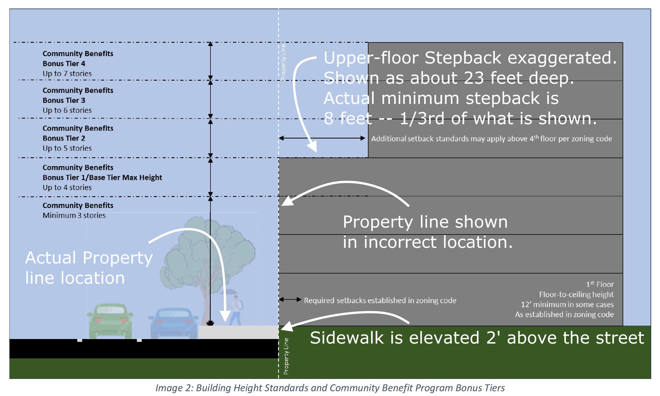
The Planning Commission has determined that and 8 foot upper-floor stepback is sufficient, and the Gateway Code is based on that. This image shows a stepback that looks to be about 23 feet deep – almost three times deeper than the Gateway Code specification. There is nothing in the Gateway Code that says that tall buildings must have a deep stepback. What’s shown is ideal, as it brings more of a sky view and sunshine to the street.
Is this misleading to the public? Yes, I believe it is.
-
Here is another misleading image, from page 45. It also appears to have been a hold-over from the 1st draft. The dimensions would be for an “Active frontage” Building, with stores, shops, restaurants occupying spaces on the ground floor. It depicts a false representation of the size of the pedestrian realm.
The Planning Commission has called for a minimum setback of 10 feet from the curb. What’s shown here is 3 feet for the frontage zone and 8 feet for the sidewalk, or 11 feet total.
The dimensions specify the frontage area being 3 feet wide (for active frontages), t he sidewalk being 8 feet wide and the Landscape / Amenity Zone at 4 feet wide.
In this image, it’s clear that the Landscape / Amenity Zone area (supposed to be 4′) is more than half the width of the sidewalk (8′). There are no dimensions on this image, as there should be.
The people, bikes, tables/chairs, etc. are place here to show us the scale of the drawing. A standard bicycle ranges from medium (53-54cm, 17-18″) at around 5′ 7″ long, to large (55-57cm, 19-20″) at around 5′ 10″ long, to extra-large (58-61cm, 21-22″) at around 6′ 2″ long. Average bike length is 5′ 10″.
 A standard-size adult bike would not fit on a 4-foot wide Landscape / Amenity Zone, as shown. This is misleading. We know the size of a bike. The drawing gives us the visual clue that the Landscape / Amenity Zone is wider than the length of a bike, which is false.
The people sitting at the café table is similarly wrongly sized — even greater. In the image, we see people sitting at tables. The frontage space there is supposed to be 3 feet — though the dimension is not marked. Shown here is an image with standard size outdoor café seating. Two people at a table is about 6 feet. Even two people on two chairs, knee-to-knee, is at least 4 or 4-1/2 feet. Again, the Gateway Code image gives us a false impression of how wide that frontage area is. It is not large enough for two people, as shown.

- We can note that the “Landscape / Amenity Zone (shown as 4 feet wide) are part of the City’s right-of-way on the street. (In most of Arcata, this space is used for sidewalk.) The Gateway Code has street trees, bicycle racks, trash receptacles, and any planters, benches, or seating installed by the property owner.
- The Gateway Code states “Street and pedestrian lighting shall be provided in the landscape/amenity zone consistent with City standards. Light poles and fixture shall comply with City standard specifications and shall be selected to be durable, vandal resistant, and low maintenance.”
The implication is that each property will select, purchase, and install the light poles and fixture of their choosing.
This seems very odd – there could be several different types of street lights even on one block. Is this what the Planning Commission wants?
• General questions, to achieve greater clarity in the document
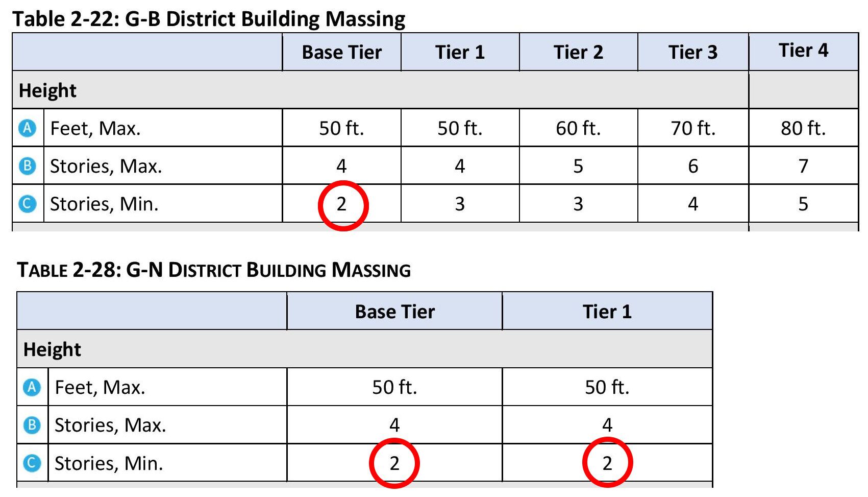
- Many tables use the word “Tier” – but the use of this word is not defined in this document. Is there a “Base” plus other tiers? What is the difference between “Base” and “Tier 1”? In the Neighborhood district table, there appears to be no difference.
In each district’s “Building Massing” tables (Tables 2-22, 2-24, 2-26, 2-28, on pages 13, 17, 20, 23), there is a “Base Tier” and a “Tier 1” and then there may be Tiers 2, 3, and 4, depending on the district. It is possible that this is a carryover from when the Barrel district maximum height was eight stories, and there were then Base (4 stories) and Tier 1 was 5 stories, Tier 2 was 6 stories Tier 3 was seven stories, and Tier 4 was eight stories.
There does not seem to be a need for “Base Tier.” The Community Development Director can tell us the need for this “Base Tier” – that is not explained in this Draft Code.

- The draft Gateway Code document refers to figures in the draft Gateway Area Plan by their numbers, such as “Gateway Area Plan Figure 8 and Figure 9” (page 15); “Gateway Area Plan Figure 7” (page 58, twice). It would helpful to spell out the name of the figure and its location in the Gateway Area Plan. Figure 7 is the “Conceptual Open Space Plan” on page 60. Figure 8 is the “Proposed Vehicular Circulation” map on page 66. Figure 9 is the “Proposed Active Transportation Circulation” map on page 67.
It is also more prudent to refer to figures that are outside this document by both number and name. A figure or map could be added to or subtracted from the Gateway Area Plan document, which would cause the numbers to shift. Having the number and name allows the reader to locate the appropriate figure in that other document.
-
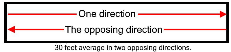
“Privately Owned Publicly Accessible Open Space” section, page 58.
“Minimum dimensions. Open space shall have a minimum average dimension of 30 ft. in two opposing directions.”
What does mean – an average dimension, measured in two opposing directions. The dimensions of a line taken from two opposing directions is the same distance. Could this be written in a different way, so that we know what is being said here? Or, since this is a form-based code, a graphic image of what the intention is? I don’t think that this is what is meant:
Errors and questions that must be addressed
• Typographic errors, improper definition, bad or wrong diagrams, numeric errors, and other issues that are confusing or misleading and counter to the intents of the Gateway Code.
These errors and inconsistencies are significant in that they can directly affect what it appears the Gateway Code says or how it might be interpreted. These must be addressed to provide an adequate Code. Ordinary typographical errors are not significant. They are listed at the end of this document.
- 1. 9.29.080 – Mobility – G. Bicycle Facilities – 4. Long‐Term Bicycle Parking Standards. (Page 54)
“Long‐term bicycle parking shall be located within 750 feet of the use that it is intended to serve.”
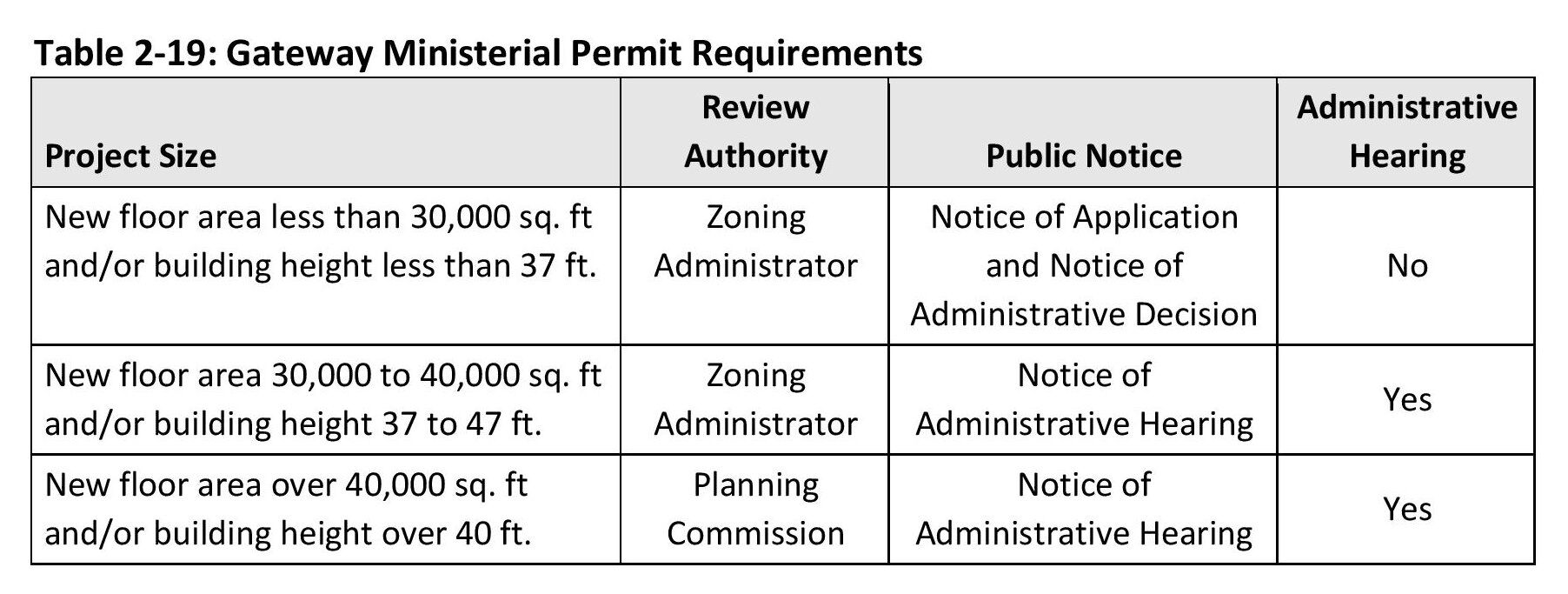
We assume this is a typo. Should be 75 feet? Surely the long-term bicycle parking cannot be located 750 feet – that’s 2-1/2 Arcata blocks — from a person’s apartment. - Table 2‐19: Gateway Ministerial Permit Requirements. (Page 5)
This table has a misuse of the phrase “and/or” — A project with new floor area of 30,000 to 40,000 sq.ft. OR building height 37 to 47 feet goes to the Zoning Administrator. At the same time, a project over 40,000 sq.ft. OR building height over 40 feet goes the Planning Commission.As it is written, a project with a building height of 41 feet goes to the Planning Commission… or to the Zoning Administrator?
Needs to be reworded. Perhaps re-write without the use of “and/or.”
As a reference, the Plaza Point building, across the street from the Co-op, at the SE corner of 8th and I Streets, is 30,371 square feet. That is, based on this table, a building of very close to that size would not be seen by the Planning Commission and would not even have a public hearing.
- Table 2-35: Publicly Accessible Open Space Requirement. (page 58)
This table shows a “Base” tier of 4 storis, ranging up to “Tier 4 – 8 stories” – It seems to be a hold-over from when the Barrel district had a maximum height of 8 stories. Needs revision.
- On page 44, under “Shared Garages and Parking Structures,” the draft Code makes a distinction between “(2) Above grade structured parking” and “(3) Partially sub-grade parking.” The line in question is (3):
“Partially sub‐grade parking (“Podium parking”) shall not have an exposed façade that exceeds 5 feet in height above abutting grade at back of sidewalk.”
This is an atypical use of the phrase “podium parking.” I have not found that “podium parking” refers to partially sub-grade parking. As such, using this phrase in this way adds confusion to the developer in understanding what is talked out here.
Podium parking can be sub-grade or above grade. In standard design and construction usage, the podium is the lower portion of the building, typical built of reinforced concrete or structural steel (steel covered with concrete for fire protection). The four or five floors above the podium can be wood light-frame construction. For examples, see arcata1.com/density-guide-for-housing-types starting at the four-story example.
“Podium parking” only means that the parking is in this podium. The podium can start one or two or more levels below grade, or a half-level below grade, or at grade.
Correction suggestion, as follows:
“Partially sub‐grade parking shall not have an exposed façade that exceeds 5 feet in height above abutting grade at back of sidewalk.”The next item on the list starts “(4) Podium parking must include a landscaped planter.” In (3) the phrase “podium parking” is used incorrectly. In (4) we don’t know if phrase refers to partially sub-grade parking (incorrect usage), or if it is referring to all parking structures. As such, the Code is unclear.
- Each district’s “Building Massing” tables (Tables 2-22, 2-24, 2-26, 2-28, on pages 13, 17, 20, 23) shows a “Base” and a “Tier 1” and then there may be Tiers 2, 3, and 4, depending on the district and the maximum height for that district.
For the Neighborhood district, it shows “Base” and “Tier 1” as being identical. For the other districts, it shows “Base” as being having a minimum of 2 stories. My understanding is the Neighborhood district has a 2-story minimum, and the Hub, Corridor, and Barrel districts have a 3-story minimum.
There needs to be consistency with the tables, with the Community Benefit tiers, and all other tables that use tiers. If Base is no longer used, it should be removed. See also “General questions for clarity” above.
- Error on Table 2-25: Gateway Corridor District Building Placement table
Maximum setback is shown as “2-0 ft.” What’s meant is 20 feet.
Note also the name of “L Street” is there, as previously discussed. The L Street corridor is now the site of the full-width linear park. It is no longer a street.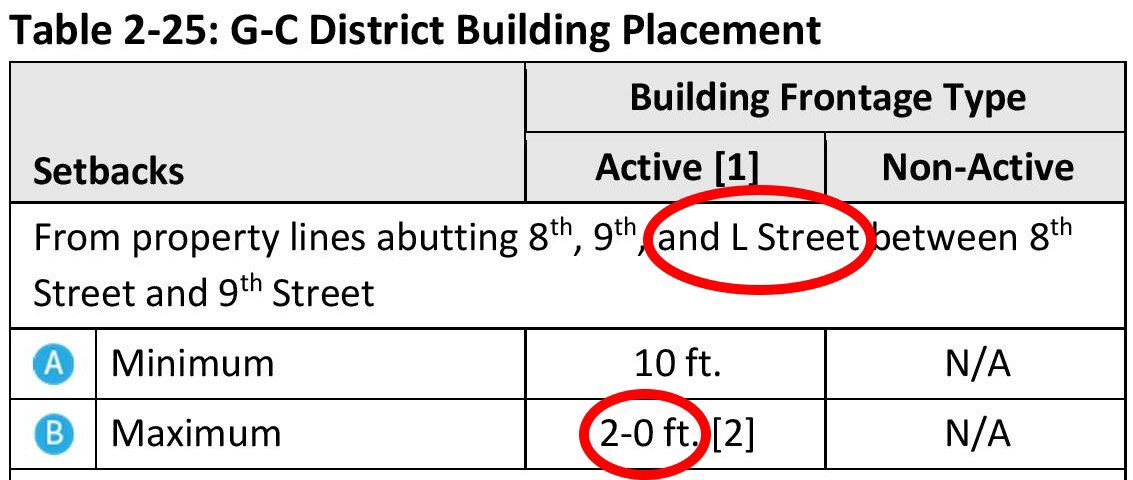
- Errors on Figure Numbers for Building Placement and Building Massing figures
While this does not affect the Code in itself, the figures should be numbered correctly. This is basic.
a. Page 18. Labeled as: “Figure 2‐25: G‐H District Building Massing”
Should be labeled: “Figure 2-30: G‐H District Building Massing”b. Page 19. Labeled as: “Figure 2‐26: G‐C District Building Placement”
Should be labeled: “Figure 2‐31: G‐C District Building Placement” - Building Placement figures not labeled properly.
The essence of a form-based code are the images that are used as guidelines. If the figures are incorrect or misleading, the Code document is not doing its job. Information in the figures that is misleading, vague, or incorrect must be corrected.
Figure 2‐26: G‐B District Building Placement. Page 12.
Figure 2-29: G-H District Building Placement. Page 16.
Labeled as: Figure 2-26 (should be 2-31): G-C District Building Placement. Page 19.
Figure 2‐33: G‐N District Building Placement. Page 22.These figures show setbacks for property lines for construction in the four districts. They show a minimum setback (A) of 10 feet and a maximum setback (B) of 20 feet from a property line abutting a street. This is valid for an “Active” building frontage type. The figures are not marked “for an Active building frontage type.”
For a Non-Active building frontage type, the maximum setback (B) has no maximum. But you would not know that from looking at these figures.
Suggestion: Two figures are needed for each district – one for Active frontage types and one for Non-Active types. That way, any confusion is eliminated. Each figure would be clearly marked for the frontage type.
Figure 2-37 on page 26 is clearly marked “Active Building Frontage Placement.” Figures 2-26, 2-29, Figure 2-26 (should be 2-31), and Figure 2-33 are not marked as being for Active frontage types.
- The four Building Massing tables show a maximum building length of 300 feet. Arcata’s blocks are 250 feet. In the Barrel district it could be possible to have a building length of 300 feet. Realistically, in no other district is this possible.
Suggestion: Replace “300 ft.” with 250 ft. for the three non-Barrel district specifications.
Consider 250 foot maximum for Barrel district building length also. - Page 34, Long Building Division.
“A building 150 to 300 feet in length, which faces a public street, right‐of‐ way, or publicly accessible path, shall include at least one vertical facade break with a minimum area greater than 64 square feet, a minimum width of 8 feet, and a minimum depth of 4 feet. See Figure 2‐46.”a. We do not want buildings of 300 feet in length. See note on this in the Building Massing tables, above.
b. The diagram, Figure 2-46, is not a valid diagram to support this policy. It shows a break of material. It does not show a break with width and depth. This policy does not mention material.Note: This is yet another example of sloppy work in this document. The Gateway Code document has many examples in which the material appears to have been copy-and-pasted from another document, without thorough reading, editing, or proof-reading.

- Section “E. Passive Open Space.” Page 60. Standards 3a appears to have been copied and pasted from the Linear Park section. It reads:
“a. The development, use, and maintenance of a linear park shall comply with all applicable City, state, and federal natural resource protection regulations.”
Change to:
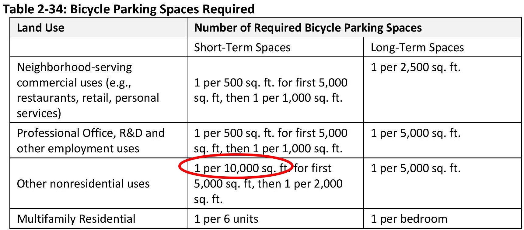
“a. The development, use, and maintenance ofa linear parkthe passive open space shall comply with all applicable City, state, and federal natural resource protection regulations.” - Error in bike parking spaces table. Page 54. The figure in the Gateway Code is 10,000. Actual number should be 1,000.
- Windows trim standards, page 42. “Windows for residential uses must have trim at least 1.5 inches in width or be recessed at least 2 inches from the plane of the surrounding exterior wall.” There is no trim standard for non-residential uses – that is absent. (A trim width of 1.5 inches also seems too narrow…but that’s a judgement that is up to the Commission to determine.)
Planning Commissioners: Suggested for further review
- Folding security gates (Scissors gates) are permitted in the Gateway area.
“d. Folding security gates (scissor gates) for storefronts, building entrances, and windows are permitted in the Gateway districts.”
This is listed under “Windows – Standards” on pages 42-43 of the Gateway Code.
Do the Commissioners want scissors gates throughout the Gateway area?
“No more than 25 percent of the site frontage facing a street may be devoted to garage opening, unless the street frontage is less than 80 feet, in which case a 20‐foot garage opening is allowed.” Page 43
For a block-long building (250 feet), this would allow 62 feet of garage door openings – that is, three 20-foot openings, or six single-car (10 foot) garage doors.
Shared garages and parking structures may have doors that face the street.
I do not believe that this is what the Commission wants to see on a building façade for an apartment building.
“Non‐Residential Transparency. A ground‐level non‐residential building wall that faces and is within 20 feet of a public sidewalk, street, pathway, or right‐of‐way must provide transparent windows or doors with views into the building for a minimum of 65 percent of the building frontage width located between 3 and 7 feet above the sidewalk. See Figure 2‐51.” Page 42.
As written, this is fine. There is a potential for abuse however.
A strong purpose of the glazing is to enhance the relationship with the street and increase the vitality of the neighborhood. There can be a situation where ground-floor commercial that was designed for a pedestrian-friendly use (e.g. retail) was then rented as office space. The new tenants put in permanent translucent window covering that blocked the view to the interior.
Suggest add: “Windows shall provide a clear and transparent view into ground floor-uses or shall display merchandise to reinforce a pedestrian scale.” (Taken from Redwood City zoning code.) And could add to that: “Windows shall not be consistently blocked or shaded so as to preclude a view to the interior.”
- I support the Greenways concept, but the policy needs a lot of improvement and clarification if it’s going to work as intended. The 9.29.080 – Mobility section starts on page 48. Section A is “Greenways.”
a. The document says “Note: The contents of this figure will be incorporated into the Gateway Plan and removed from the code.” – but that has not happened yet.
b. The Greenways concept is a nice idea, but it appears to have not been thought through carefully or correctly. - Here is Figure 2-56, on page 49:
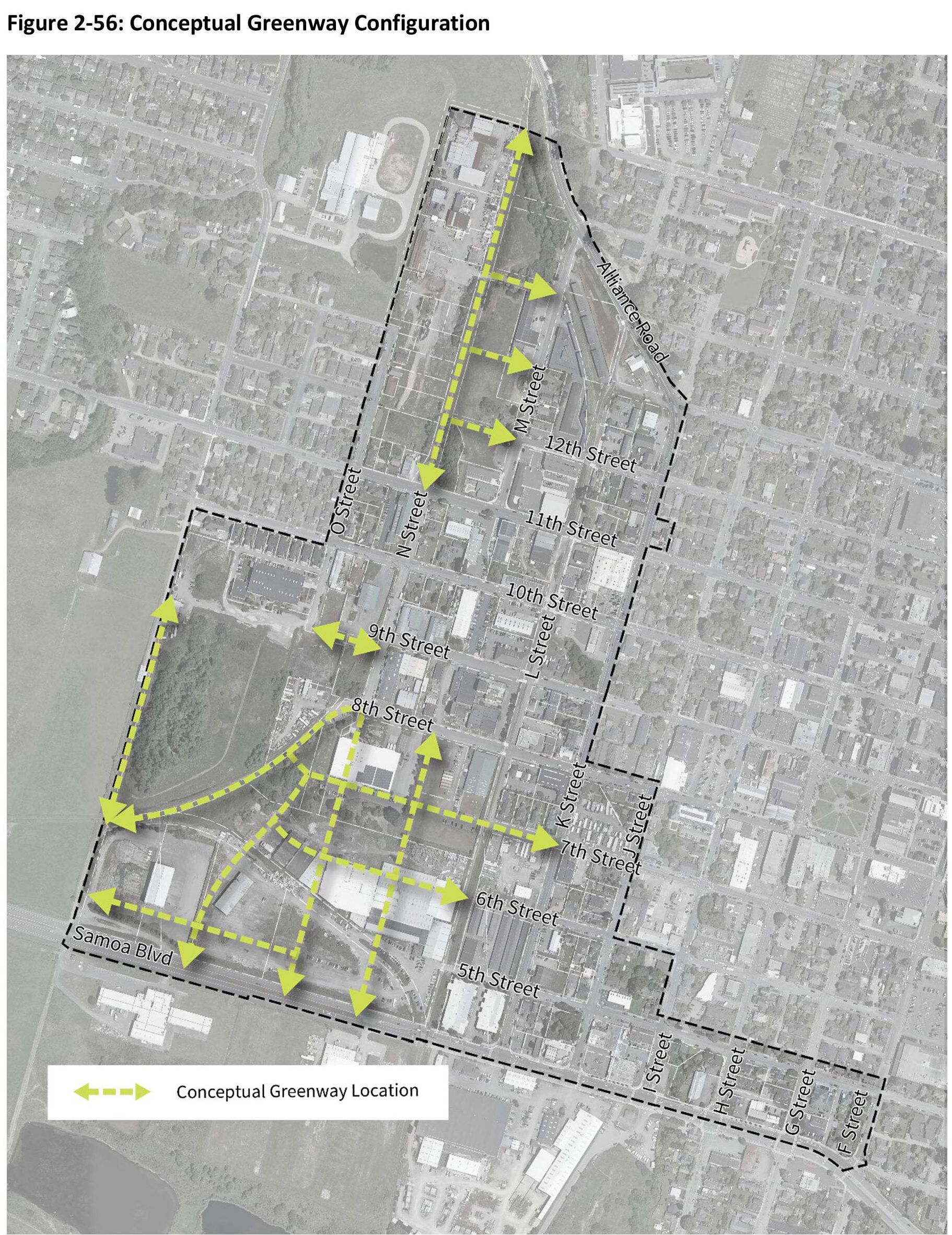

Close-up of Greenways in the Barrel district and southern Corridor district. -
There are a few points we can note.
-
The draft Gateway Code states “Greenways are required in the approximate locations shown in Figure 2‐56.”
-
Figure 2-56 shows the Greenways going through large swatches of private property. The greenway that starts behind the Greenway building (the name is a coincidence) on where 7th Street would be, west of the L Street corridor, runs through private property. The City does not have the rights of way for this. The greenways proposed for the southern section of the Barrel district are all on private parcels.
-
The greenway that ends with an arrow that ends on 6th Street is shown going through an existing building.
-
The greenway that ends with the arrow on 7th Street appears to run right down 7th Street for the block west of K Street. This is where the four Devlin Cottages are located. A greenway in this location would prevent the owners from having access to their homes.
-
The total width required for a public access easement is 26 feet, based on a 15-foot setback. Would the property owner be responsible for the construction and maintenance of the setback area and/or the easement? Is the 26-foot section deeded to the City?
-
- The southern portion of the Barrel district requires a master plan. With this arrangement for the greenways that is presented in this draft Gateway Code, it appears the layout of this master plan has already been determined.
- A community square – public area – is called for in the Barrel district. It is a requirement of the master plan for the southern portion of the Barrel district.
- The Gateway Code does not specify if this area will be a privately-owned publicly-accessible space – in which the owner or the property is responsible for the cost of the development, liability, enforcement, and upkeep – or if this area is intended to be deeded to the City, for the City of Arcata to handle development and upkeep.
“10. Lighting sufficient for nighttime use.” Page 56.
This would be improved with better definition. Does this mean lighting to the level that, say, the Arcata Plaza has lighting? Or, as there may be a pavilion there, does it mean lighting sufficient for nighttime concerts.
Or leave as-is.
Review and Approval Process. Page 15.
The draft document says: “The Master Plan will be reviewed and approved at noticed public hearings in the same manner as required for amendments to this chapter and the Gateway Area Plan if deviations from the standards are proposed.”
I believe the Master Plan is meant to come to the Planning Commission for review and approval. Whether there are deviations from the standards is immaterial. The Master Plan must be approved by the Planning Commission.
- Question of “street” setback for buildings alongside the L Street corridor linear park, and along greenways and woonerfs.
Is the Gateway Code going to allow a developer to build right up to the property line – along the L Street corridor linear park?
Each district has a table with specifications for setbacks from the property line for building placement abutting a street, abutting an enhanced setting, from side property lines and from rear property lines, or from all other property lines. For the Hub, Barrel, and Corridor districts, there is no setback requirement for other property lines.
The question is this: The L Street corridor is no longer a street. It is the location of a full-width linear park. As such, it is not a street, and therefore the “other property lines” minimum setback requirement would be used. That is: Zero feet, no setback. Since it’s not a street, there would not be a requirement for sidewalks either.
A similar situation exists along greenways and woonerfs. Based on the draft Gateway Code emphasis on greenways (See map of greenways. Figure 2-56, on page 49
The Planning Commission needs to clarify this.
See also the discussion earlier in this document about upper-story setbacks along public open spaces. As illustrated:
- Page 10. “Auto and vehicle sales and rental” are prohibited uses.
This would seem to exclude short-term (hourly) car rental services, also known as car-sharing services. The most well-known company currently is Zipcar.
Car-sharing / short-term car rental services should be an allowed use. - “Vehicle services” is prohibited. What about Electric Vehicle (EV) charging stations?
Page 4. “F. Periodic Planning Commission Review. Two years after the effective date of this chapter, or six months after the issuance of a certificate of occupancy for the first project approved pursuant to this chapter, whichever comes last, and then every two years thereafter, the Planning Commission shall undertake a review of this chapter and determine whether to recommend that the City Council amend, modify or delete, in whole or in part, any of its provisions.”
The Planning Commission can review this Gateway Code at any time. Because this form-based code and the entire Gateway Area Plan are new concepts to Arcata planning, it is suggested that the initial review shall take place earlier rather than later.
Suggestion: Change “whichever comes last” to “whichever comes first.” Also, change “six months after the issuance of a certificate of occupancy for the first project approved” to “six months after the first issuance of a certificate of occupancy.” The issuance of a certificate of occupancy to the first “approved project” could be delayed for unknown reasons.
Pages 4, 9, 52. “Eligibility. To be eligible for a Gateway Ministerial Permit…The project must provide housing…residential uses must either: 1. Occupy at least two‐thirds of the total floor area of the project…” etc.
Later sections of the code refer to commercial uses of 25,000 square feet and 40,000 square feet. (Parking for carpools and vans for floor area of over 40,000 sq.ft. — Table 2-33, page 52.) Such large commercial uses would be not be eligible for a ministerial permit, but could be constructed after obtaining a Use Permit.
Question: Under what circumstances would there be a 40,000 square foot commercial building in the Gateway area? Isn’t the overriding purpose of the Gateway Plan to supply housing?
Page 9 provides a requirement to “contribute to the vibrancy of the Gateway Area” as providing an estimated 100 jobs. Is this what is desired in the Gateway area?
A 40,000 sq.ft. commercial building is roughly the size of the 4-story Sorrel Place, on 7th Street between I and J Streets. A commercial space of this size could have parking of 1 space per 500 sq.ft. to 1 space per 1, 000 sq.ft. or between 40 and 80 parking spaces.
In my opinion, a commercial space of 40,000 or even 25,000 square feet in the Gateway area is not appropriate, whether it is office space, R&D, retail, or other.
References to buildings of this size can be examined and if necessary reduced or eliminated.
A hotel of 100 or more rooms would require a site of several acres — meaning that if a hotel of that size to be built, the Barrel District would be a more likely location. However, a 66-room or so hotel can be built in an area the size of an Arcata block (1.42 acres), and a smaller “boutique” hotel can be built more or less anywhere.
Is this an intended use in the Gateway area? We can note that a 66-room hotel is eligible for 66 parking spaces. An apartment building that has 66 units in the Hub or Corridor districts would be limited to 17 parking spaces.
From independent (outside of the Commission meetings) conversation with Community Development Director David Loya, I’ve learned that he feels that a hotel in the Gateway Area would be a good thing for Arcata.
See: arcata1.com/ministerial-review-hotel-not-approved-by-pc
Pages 5, 6. c. Environmental Review, section 3. “If the project site is included on any list compiled pursuant to Section 65962.5 of the Government Code, or is on a local or regional list of hazardous sites and has not received a clearance letter or land use covenant, it is not eligible for a Gateway Ministerial Permit.”
The Planning Commission may want to review this topic, in conjunction with what is stated in the General Plan Environmental Impact Report on page 3.5-3 (PDF page 177). This is linked directly to a discussion of this matter on the Arcata1.com website at: arcata1.com/eir-comments-from-fred-weis-submitted/#_Toc161672202
The issue is this: There are dozens of locations in the Gateway area that had contamination of one sort or another, and which were either cleaned up or considered to have a low level of contamination. That determination was made based on the site having Industrial zoning. The site was “investigated and remediated” and qualified for another Industrial use. If the zoning changes, as the Gateway Area Plan is doing, what was considered remediated may now considered restricted.
From the EIR report. These are quotes:
“Inactive sites are defined as having been investigated and remediated to the satisfaction of the lead oversight agency.
Residual contamination at levels that do not pose significant health risks to the current land use may still be present at inactive sites.
However, inactive sites can be restricted for future land uses that require completely remediated conditions.
For example, an unauthorized release at an industrial property could be remediated to cleanup levels appropriate for future industrial land uses, but the residual levels of contamination after remediation may be too high and pose health risks for other types of future land uses such as residences, schools, or parks.”
- The “Gateway Use Permit Requirements” allows Zoning Administrator review if new uses are under 25 units per acre.

From pages 8-9.
For new or existing commercial or industrial use, the table is simple: 2,500 square feet or less then it’s Zoning Administrator review. 2,500 square feet of more, then it’s Planning Commission review.
For residential uses, it’s trickier. The Code refers to “9.72.080 (Use Permit and Minor Use Permit). This and the companion 9.72.040 (Design Review) are in Arcata’s published Land Use Code, and can be seen here: https://www.codepublishing.com/CA/Arcata/LUC/ArcataLUC0970/ArcataLUC0972.html
Suggestion: Have all Use Permits for construction of more than 2,500 square feet in the Gateway area go through the Planning Commission. Do not have Zoning Administrator review based on less than 25 units per acre. That would be counter to the intentions of the Gateway Area Plan.
There is nothing in the current Gateway Code about mechanical systems equipment not being located on a street frontage. Even if placed behind a fence, this is considered as a lower-quality design.
The Commissioners may want to consider an addition to the Code on this issue.
In the current draft Gateway Code, active building types are required for the area around the Creamery building: On the north and south sides of 8th and 9th Streets; on the east side (Creamery side) of N Street; and along both sides of “L Street” – which is no longer a street, as discussed. See Figure 2-36, page 25:
Suggestion: The Commissioners may wish to expand the area where Active Frontage types are required. Possibilities include:
- 11th Street, north and south sides, from K Street to N Street. This would include the Clothing Dock and the Ag Sales building sites, the current single-family residences on the north side of 11th Street west of K Street.
- K Street, west side, from 10th Street to Alliance Road. This would include the K Street side of the Clothing Dock building, with existing one-story retail shops.
- K Street, east side, for the half-block north of 11th Street. This would include the gas station site.
- Possibly locations on the east and west sides of K Street, perhaps between Samoa Boulevard and 10th Street. This would include the Bud’s mini-storage, the AmeriGas site, the St. Vinnie’s site, and more.
Suggestion for the L Street corridor full-width linear park: The Commissioners may wish to consider what may be wanted along the sides of the linear park. It is possible a restaurant / small retail shop experience may be desired. As such, the Commission may wish to include the entirety of the L Street corridor, both sides as where Active Frontage types are required. A plan for the L Street corridor full-width linear park will be developed at some point, and the desirability of having Active frontages there can be determined then.
Open Space section, page 56. In the 3D image on page 2 (close-up below) it shows a vehicle road on one side of the public square. We are aware that the 3D images are just an example of what could be built and do not represent actual building and planning designs.
The Master Plan will determine where the public square is placed, and what the road arrangement is. The Commission may want to specify the vehicle roadways and the amount of parking that is adjacent to the public square – or the Commission may choose to take this on when a Master Plan comes to them for approval. (Will the Commission be the approval body for the Barrel Master Plan? See comment on this, above.)
See “Amount of Open Space Required”, page 58.
“a. Within the “private open space” area shown in Gateway Area Plan Figure 7, a project participating in the community benefits program must either:
(i)Provide publicly accessible open space in the amount shown in Table 2‐35; or
(ii)Pay in‐lieu fees to be used by the City to construct off‐site public open space.”
Strong Suggestion: Change to “Pay in‐lieu fees to be used by the City to construct off‐site public open space within the Gateway area.”
Without this clause, park in-lieu fees would go into a general park fund, and might be used for maintenance on a park that is one or two miles away. (Even though the clause says “construct” the funds may be co-mingled with other park funding.)
Having a park that is outside of the Gateway area is contradictory to the intent of creating a neighborhood. Even though a person can ride a bike to a park that is a mile or two away, to have that be a “go-to” park is a tacit encouragement of vehicle usage.
I have spoken and written on this many times. See arcata1.com/parks-open-space and “The Myth of “Privately-Owned Publicly-Accessible” Open Spaces” at arcata1.com/the-myth-of-privately-owned-publicly-accessible-open-spaces
The Gateway Area Plan states “It is anticipated that City Park in-lieu fees collected from residential development in the area will be sufficient for purchase and at least partial development of new parkland facilities.” (Page 59.) It does not say “within the Gateway area” – but it should.
This will not happen unless the Commission or the Council insists on it.
We have been told that park in-lieu fees go into a City-wide pool. There are alternatives. The Gateway area should have its own assessment district.
If you have not already done so, Commissioners are encouraged to view the 194-page (very dense pages) form-based code Redwood City Downtown Precise Plan, originally from 2011. It can be viewed at arcata1.com/redwood-city-downtown-precise-plan-html For what is essentially a technical document, it has become a highly-viewed article on Arcata1.com, with other 1,100 views.
The Redwood City Precise Plan covers 183 acres. A stated and achieved goal was an abundance open space “parklets” and park areas.
- There are 23 public open space areas in the plan. 96% of all parcels in the plan are within a 3-minute walk of an open space.
- Of the 23 public open spaces, 10 are designated as “Shadow Sensitive.” Maximum permitted building heights are reduced near these spaces.
Why can’t we do this too?
Parks and parklets are crucial. People living in a dense environment need a place to walk to, to meet friends, to relax outdoors, and so forth. The L Street corridor linear park and the Barrel district one-acre “square” are a great addition to the Gateway area, but are hardly enough. The trails and creek daylighting are also outstanding contributions to quality of life.
If there are going to be 1,000 or 2,000 or 3,000 people living in the Gateway area, there needs to be planning for parks. As such, it is of great value for all in-lieu park fees stay local to the Gateway area.
The section in the Gateway Code on “Privately Owned Publicly Accessible Open Space” starts on page 57 and continues through page 60. (There is an error in Table 2-35 on page 58 – this has been discussed, above.)
This section in the Gateway Code refers to Figure 7 in the Gateway Area Plan. This is the “Conceptual Open Space Plan” map and can be found on page 60. I will include some images from this map here, below.
In my view, while the concept of Privately-owned Publicly-accessible open space is a noble concept, in practice it is unlikely to work out. The reason is simple: It costs more to the developer to create and maintain – in perpetuity — this open space than it would cost to simply pay the in-lieu fees.
As a result, the notion of parklets and parks within the Gateway area will not occur. There will be the 1-acre pubic “square” in the Barrel district, and the L Street corridor full width linear park, and the proposed linear park on the railroad right-of-way on N Street, north of 11th Street. And all that is superb. But as for small neighborhood spots where people can meet and sit – not likely.
This is such an important topic that the Commission may want to devote an hour or so – or an entire session – to its discussion.
There’s always lots of talk about the necessity of building community.
Parks and outdoor meeting spaces: This is how you build community.
I wrote about this situation in the article The Myth of “Privately-Owned Publicly-Accessible” Open Spaces at arcata1.com/the-myth-of-privately-owned-publicly-accessible-open-spaces. Estimated reading time is 12-14 minutes. The article needs some updating to bring up to the current Community Benefits program specs, but the concepts of what are expressed remain valid.
In a nutshell: If you were a developer and you were constructing a $15 million apartment building on a half-block sized lot, which would you rather do?
- Build a public space.
- Eliminate 12.5% of the land area on your site from the total area used for a new building.
- Design a new building and parking, pathways, entrance, etc. on 87.5% of the existing parcel.
- Design a 3,850 public space, with brick or concrete walking surface, planter boxes, landscaping, outdoor seating, trash cans, and so forth.
- Have that public space built, and pay for the cost of that.
- Provide daily clean-up, security, maintenance and upkeep, and landscaping for this public space — in perpetuity. For the life of the building.
- Insure it and have the liability of legal responsibility for all activities that take place on this site, as it is remains your legal responsibility, as owner of the property.
or –
- Pay $225,000 to the City as in-lieu fees. That’s it. Pay it once and be done.
A possible solution: Double or triple the amount of the in-lieu fees. That would cause developers to think about what would be the better option.
You may ask: Won’t higher fees and more costs to the developer make it more expensive to build — and therefore result in higher rents?
In a sense, yes. But there are many costs involved in constructing an apartment building. You wouldn’t declare “If we have to pay for Worker’s Comp insurance, then we’ll have to have higher rents” or “Why do we have to have a fire-suppression sprinkler system? It will just make the rents higher.”
Providing open space for people is a cost of doing business. If parks are minimized or disregarded, the quality of life of everyone suffers.
To repeat what was written earlier: in the Redwood City Downtown Precise Plan, covering 183 acres, there are 23 public open space areas in the plan. 96% of all parcels in the plan are within a 3-minute walk of an open space.
Our Community Development Director has told us from the beginning that the streamlined approval and certainty of approval that comes from the use of objective standards would provide savings of hundreds of thousands of dollars to the developers, in the form of quicker approvals, lower interest costs, greater certainty of getting the project approved, and easier to understand building codes and requirements. He told us that this would enable the developers to give back to the community those hundreds of thousands of dollars that they’d save.
Well, here is their chance to do just that. The community needs parks and playgrounds and gathering places, of all sizes and configurations.
Please note: Within the designated area shown on the map, developers are required to provide open space or pay the in-lieu fees. In my view, the boundaries for mandatory participation in the “Privately-Owned Publicly-Accessible” Open Space program are arbitrary. The boundaries do not provide the best benefit for people, and do not represent good planning. See “The Myth of “Privately-Owned Publicly-Accessible” Open Spaces” for more on this.
Figure 7 from the Gateway Area Plan, the “Conceptual Open Space Plan” map. page 60. What is inside the red line is called “Private Open Space” – it is where the developer must either provide publicly accessible open space, or pay the 1.5% in-lieu fee. See page 58 of the Gateway Code.
The same map with labels, for orientation: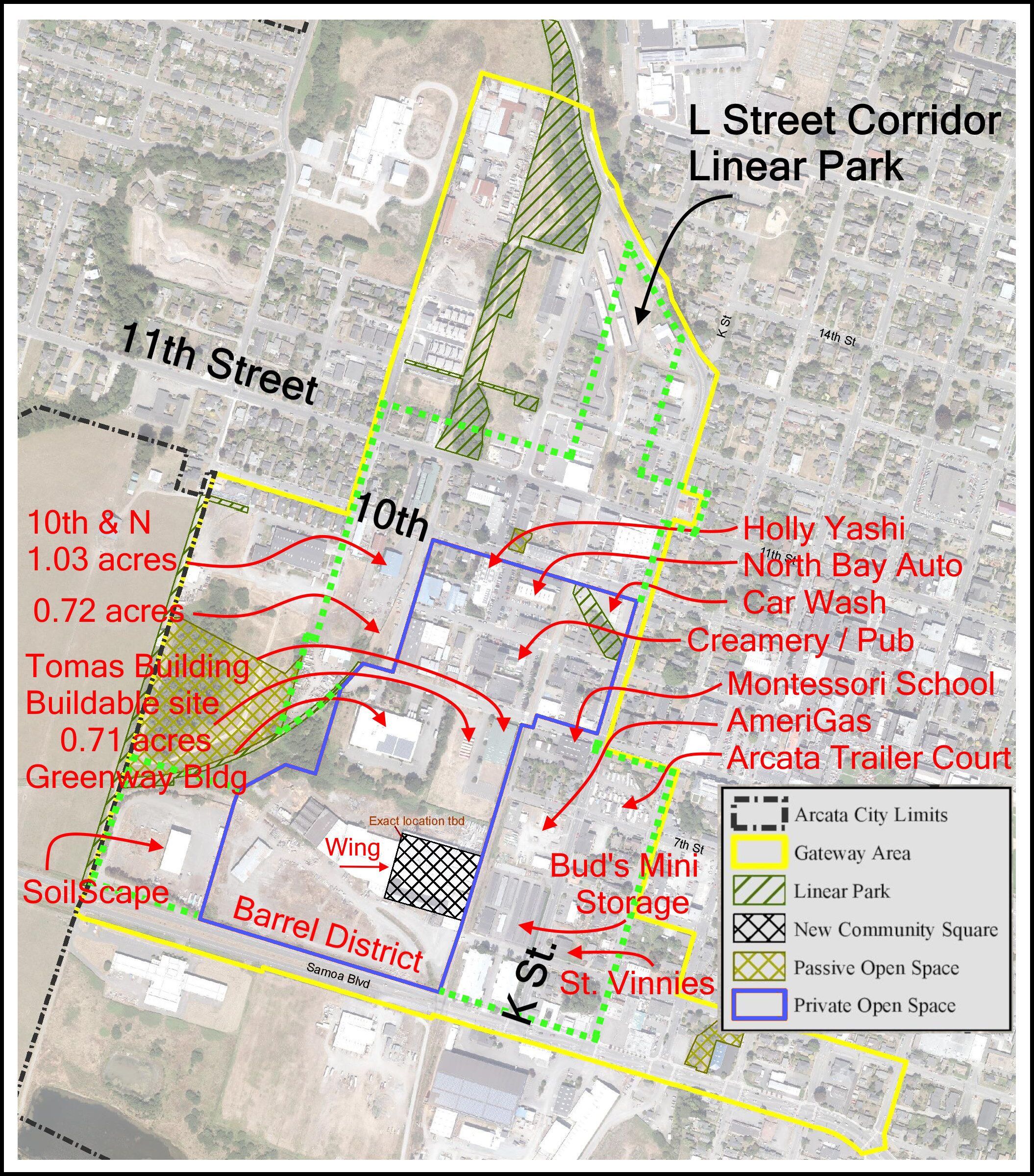
- Privately-owned publicly-accessible spaces – Other issues
- Awnings and other Coverings can cover up to 50% of the square footage of the open space. That seems like a lot – too much. Page 59, item 10.
- On sites with ground-floor non-residential uses, frontages adjacent to the open space must be at least 50% made up of active uses. Page 59, item 8a. This sounds like a good idea, but may be problematic. Let’s say there’s a design with active uses (restaurants, shops) and inactive uses (offices) on the ground floor. The developer may want to put the active uses (restaurants, shops) on the street, and put the offices in the back, where it’s quieter. The privately-owned publicly-accessible might also want to be in the back.
I suggest leaving this in, and add a clause, to the effect that this can be modified on a case-by-case basis. - “Active uses, open spaces and entries shall be oriented to the open space.” Page 59, item 8b.
This says that open spaces shall be oriented to the open space – looks like a poorly-written sentence here. Suggest re-write for clarity. - “Open space furniture and other elements are permitted to occupy up to a maximum of 40 percent of the area of a plaza or open space.” Page 59, item 9. Having 40% of public space covered with tables and chairs and planters sounds like a lot. It’s up to the Planning Commissioners on this one.
- Important: “Active uses are permitted to spill out into open space if they provide seating and shading.” Page 59, item 8c. This means that an active use – a restaurant – that is adjacent to the privately-owned publicly-accessible space can spill out into the open space.
Again, an idea that sounds good – having restaurant chairs and tables outside. But when that restaurant does that, those tables and chairs are proprietary to the restaurant, and that “publicly accessible” open space effectively ceases to be publicly accessible.
We know the layout for Brio, on the Plaza. Imagine that layout in a different location – at a ground-floor active-use location in the Gateway area. It fronts onto a 1,000 square foot privately-owned publicly-accessible space. According to this clause in the Gateway Code, the restaurant could set up outdoor tables and chairs, just as Brio has done on their own property at the corner of the Plaza. That Gateway restaurant would then have hijacked (taken over) what was supposed to be publicly-accessible space. And the ordinary citizen would not even know that they were allowed to be there, sit down at a table, and not buy food.
Suggestion: Perhaps limit the total of all tenants in the building to occupy a total of less than 30% of the area of the open space, for all elements.
A similar situation came up in the Community Benefits conversations, where it was pointed out that certain “benefits” that were on the list really were for the benefit of the building’s tenants. In that way, a privately-owned publicly-accessible space should not exist for the primary purpose of benefitting the occupants of that building.
- To note: Garage entrances, driveways, parking spaces, loading docks, trash or other solid waste storage facilities (fixed trash receptacles are okay), and mechanical systems exhaust all are prohibited in the privately-owned publicly-accessible space.
The Gateway Code establishes that parking spaces must be unbundled from cost of rent or purchase for residential uses, and unbundled from the cost of a leased commercial space. (Pages 51, 52.) The specifics are:
- Commercial: “…the cost of the parking space shall be included as a separate line item in the commercial space lease.”
- Residential: “The cost of the parking space must be included as a separate line item in the unit sale price or rental agreement”
- Transportation Demand Management for non-residential use over 10,000 cumulative square feet, as an option (not required): “f. Parking cashout option where employees are given the option to receive a cash payment in lieu of a parking space.”
The concern is that there is not clarity on what would be a reasonable or appropriate amount for the value of a parking space. That is, a developer could choose to have a parking space be a line item of one dollar, or an employer offer an in-lieu cash-out of one dollar – and that would satisfy the wording of these clauses.
Suggestion: Add language such as: “Separate line item amount for unbundled parking, or cashout option for employees is not to be less than $75.00 per month, adjusted on April 1 of each year based on the prior year average CPI, or adjusted by the Planning Commission as part of Gateway Code update.”
I recognize that this is micro-management, but this level of specificity may be necessary in order to support what I perceive as the intentions of the Commission. The example amount of $75.00 is an arbitrary figure, and we may see some differences of opinion on this. I would say that $100 per month might be too high and $50 per month might be too low. The cashout option for the employee may be set higher.
This sentence is on page 56. There are three parcels owned by the Northwest Pacific Railroad.
Orientation: At the northwest corner of 11th and M Streets is the Little Learners Preschool and Pre-K building. Going west from there is a 0.45 acre parcel with 89’ street frontage, owned by the City of Arcata and marked as “11th & M St. Detention Basin.” Jolly Giant Creek flows through this parcel.
West of that is the Northwest Pacific Railroad right-of-way. The Eureka-Humboldt Fire Extinguisher Co. building is next. The Northwest Pacific Railroad parcel is tapers to be wider along 11th Street and actually crosses over the existing fence and driveway of the Fire Extinguisher parcel.
The parcels that would contain a linear park measure about 50 feet wide, but narrows to about 28 feet wide for a small portion, up at where 16th Street would be. An N Street linear park would provide a trail from Alliance Road at the corner of Shay Park to 11th Street. Development is expected to occur at the old Reid & Wright mill parcels, located on the west side of “N Street” for 2-1/2 blocks at the north end of the Gateway area, up to where 16th Street would be, and for the parcels along M Street, where Bug Press is located, plus other sites on M Street.
An N Street linear park would also run alongside the Dellanina Nature Preserve, about 2-1/2 acres in total.
Among the questions for the Commissioners are:
- Is the intention for the City of Arcata to acquire this property and develop the linear park?
- Does the City have intentions of developing the Dellanina Nature Preserve? This is shown in the Gateway Plan as Passive Open Space.
- Will this linear park meet the standard of “Bollards with integral lights or pedestrian scaled lights shall be placed along the linear park for visibility and security.” (Page 57)
[Note: This is not part of the Gateway Code, but worth mentioning. The Reid & Wright parcels total a bit over 5 acres, and so this represents a sizeable development site. (Location: On the west side of “N Street” for 2-1/2 blocks at the north end of the Gateway area, up to where 16th Street would be.) The only access is by the block-long stub of 14th Street that runs from M Street to “N Street” – it currently looks like a driveway. In the Gateway Area Plan document, this stub of 14th Street is shown on Figure 9, the “Proposed Active Transportation Circulation” map as being a multi-use path. This needs correction.]
- The N Street bikepath will run from 11th Street to Alliance Road. Perhaps it can be continued into the Barrel District, for those 4 blocks. That leaves a gap of 3 blocks. The two parcels on N between 8th and 10th are likely candidates for redevelopment. Perhaps some accommodation for a Class I bike path can be extracted from that property. The railroad tracks there are not in a separate right-of-way as they are north of 11th Street.
- With two parallel bikepaths that are two blocks apart, perhaps the N Street path could be designate for higher-speed commuting and travel, and the L Street bike path more for ambling and relaxing.
Page 52, F. Parking Location and Design
“K, L, and N Street access. Site designs for commercial or residential projects that qualify for ministerial approval may not have primary access for motor vehicles to parking from K Street, L Street, or N Street if access from an east‐west street or from an alley is possible, with exceptions for emergency access.”
First, “L Street” will be taken out of this paragraph, as it is no longer a street.
There are two parcels on the west side of N Street between 8th and 10th Streets, to the west of the Creamery / Holly Yashi / The Back Porch area. Currently there is a fence that along the border of those two parcels, with no apparent gates. The entrance to the parcel at the SW corner of 10th and N Streets is on 10th Street.
This location on N Street is the “turnaround” block for the 8th and 9th Street one-way couplet that is part of the circulation plan for the Creamery district.
To encourage designs for those two parcels to “join” the Creamery district activities, it may be better to have development on those two parcels be based on an entrance on N Street.
N Street north of 11th Street will be a linear park. N Street has only three blocks that this policy would be apply to. It is suggested that this policy be looked at for those three blocks for each parcel on an individual basis.
Page 53. “6. Screening. The perimeter of a surface parking lot facing a street shall be screened with a minimum 3‐foot‐high evergreen hedge, fence or wall. Fences must be at 75 percent opaque.”
The paragraph above says: “5. Parking Placement. Surface parking spaces may not be located in the area between the front and street side property line and a line extended horizontally from the exterior building walls to the edges of the lot. See Figure 2‐58.”
If there is no parking allowed between a building – extending to the edges of the lot – then where is the need for a fence for a parking lot that faces the street?
If I am missing something here, then the Code needs a better explanation. If a parking lot that does not face a street should have a fence, then this should be worded differently. If it is possible to have parking that does face the street, then that should be specified also.
Not as eligible for ministerial approval, but as a permitted use. It could be argued that it would be for “visitor‐ serving uses that promote local tourism.” (Page 9.)
A parking garage is not on the list of prohibited uses.
As an under-40,000 square foot structure, it could have Zoning Administrator approval.
- Shadow Mitigation is part of Arcata’s Land Use Code. This should be made more clear in the Gateway Code.
The provisions of this Chapter are intended to protect access to solar energy for future development in Arcata by serving as a guideline for new development. This is done by setting limits on the amount of shading permitted by new construction and requiring that new buildings be sited to maximize solar access.
The Arcata Gateway Code does not have anything specific to say about solar access, and nothing on shadow mitigation. It refers to “Chapter 9.56” which is a chapter of the Arcata Land Use Code. This can be found at: https://www.codepublishing.com/CA/Arcata/LUC/ArcataLUC0950/ArcataLUC0956.html
It starts out with these sections, below. I have added the red highlights.
“9.56.010 Purpose and Objectives
- The City recognizes the importance of protecting the potential for solar energy use. The purpose of this Chapter is to maximize access to sunlight for City residents.
- This Chapter is intended to implement the California Solar Rights Act and the California Solar Shade Control Act, as well as to strive to meet the City’s energy policy goals as outlined in the Arcata General Plan 2020. The provisions of this Chapter are intended to protect access to solar energy for future development in Arcata by serving as a guideline for new development. This is done by setting limits on the amount of shading permitted by new construction and requiring that new buildings be sited to maximize solar access. Proper building siting and orientation is required to fully utilize solar energy. These measures will benefit the citizens of Arcata by reducing dependence on non-renewable energy sources.
- The potential economic and environmental benefits of solar energy use are considered to be in the public interest; therefore, local governments are authorized to encourage and protect access to direct sunlight for solar energy systems. Solar easements are appropriate to assuring continued access to direct sunlight for solar energy systems, and may be created and privately negotiated.”
This section of the Arcata Land Use Code is concerned mostly with preserving solar access on new construction. It speaks only indirectly to the protection of solar access on existing buildings.
Consider the following, from the Redwood City Downtown Precise Plan (form-based code), page 87. Again, highlights in red were added.
“2.7.5 Shadow Impact Mitigation
It is the goal of the Downtown Precise Plan to mitigate the impact of shadows on important public space when feasible and consistent with the other goals of this Plan. The regulations set forth in prior parts of this Section, especially Maximum Height, are based in large part on this goal. The following regulations shall apply to designated shadow sensitive public open spaces (see height map) within the Downtown Precise Plan Area, although the heights in this plan have been reduced to make it self-mitigating (meaning full building out of the Plan would not cause the threshold below to be violated) and no additional reductions in height are necessary to comply.
1.Standards
There are no Shadow Impact Mitigation standards.
2.Guidelines
a. No new structure built within the Downtown Precise Plan Area should cause any of the following parcels and building elements to be more than 50% in shadow at 12:00pm on the Spring Equinox. Parcels and building elements which exceeded the shading standard at the time of the adoption of the Downtown Precise Plan shall not be subject to this policy. Maximum permitted heights have been calibrated in this Section to ensure that this guideline is met by all new development, which is studied in detail in the Environmental Impact Report. Compliance with subsections 2.7.1 through 2.7.3 of this Section shall therefore be sufficient to indicate compliance with this guideline.
• Shadow-sensitive public open spaces (Courthouse Square, Theatre Way, City Hall Park, Library Plaza, Hamilton Green, Depot Plaza, Little River Park, Redwood Creek, or City Center Plaza as shown on the Downtown Precise Plan Public Open Spaces Map) ;
• Downtown parcels with lower maximum permitted building heights adjacent to parcels with higher maximum permitted heights;
• Residential properties located outside but adjacent to the DPP area;
• Light-sensitive features on historic resources; and
• Historic facades.
More from the Redwood City Downtown Precise Plan (form-based code), page 85. Again, highlights in red were added.
The section and diagram are for the relation to single-family homes. The same standards apply to new construction adjacent to public open spaces.
“Relation to Single Family Homes
A relational height limit to single-family homes is established in order to create an appropriate height relationship where new development is adjacent to existing single-family homes.
1.Standards
- The relational height limit shall be required for areas as shown in the Height Regulations Chart.
- Where the relational height limit is required, the limit is applied to new development on any parcels that abut another parcel with an existing detached single-family home.
- The relational height limit is controlled by a 45-degree slope originating at a height of 15 feet along the applicable property line (creating a 1 to 1 height to setback ratio) as shown in the diagram below.”
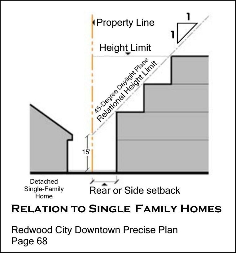
(Text replaced because original was fuzzy. “45-Degree” text added from a similar diagram.)
Suggestion: Discuss and possibly incorporate a design standard similar to the Redwood City 45-degree daylight plane for Gateway area buildings that are adjacent to existing single-family homes, adjacent to public open space, and existing residential apartments of one- or two-stories.
Consider the 3D images supplied by Community Development Director David Loya in his “Building and Massing” video series from August 2022. The hypothetical examples of Gateway area building designs show deep, graduated upper-story stepbacks where the new building was adjacent to existing lower-height residential properties.
While the examples in the “Building and Massing” videos were not intended to be the actual designs of what would be built, those videos and other conversations at that time were viewed by the public as what might be expected when a four- or five-story building is constructed directly adjacent to existing residential use.
The current Gateway Code offers no such shadow or privacy protection.
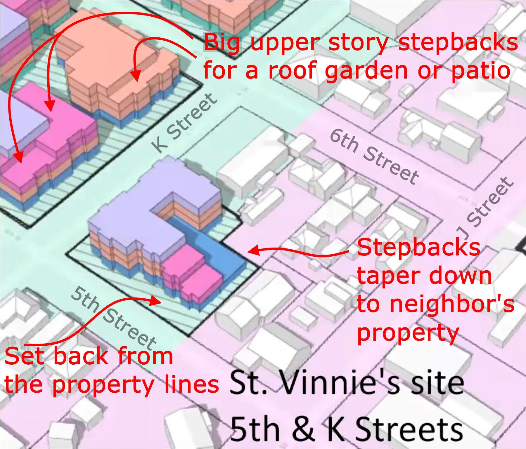
On page 44, under “Shared Garages and Parking Structures” we see this in the Gateway Code. Highlight added.
“(2) Above grade structured parking levels facing a public right‐of‐way or publicly accessible open space/path, with the exception of vehicular alleys, must either be lined with commercial or habitable uses with a minimum depth of 20 feet or feature a façade with the appearance of habitable uses.”
A minimum depth of 20 feet – for either commercial or habitable use – is not much. Thirty feet might be more appropriate. A possible use for a 20-foot-deep commercial space would be for “mini-stores” or bodegas – but would we want rows of them in one location?
Suggestion: Remove the phrase “or feature a façade with the appearance of habitable uses.”
Starts on page 26. Map is on page 27 as Figure 2-38. Here is the full map: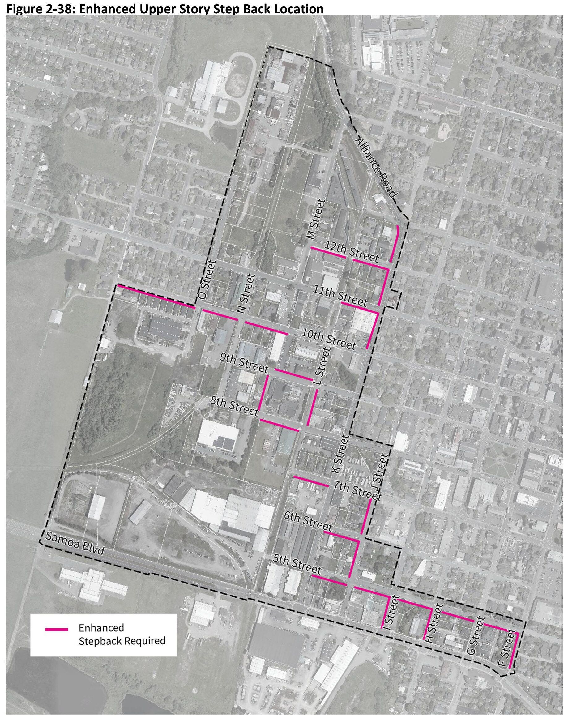
Here are the north and south portions of the Enhanced Upper Story Step Back Location map, with each section of street frontage.
North: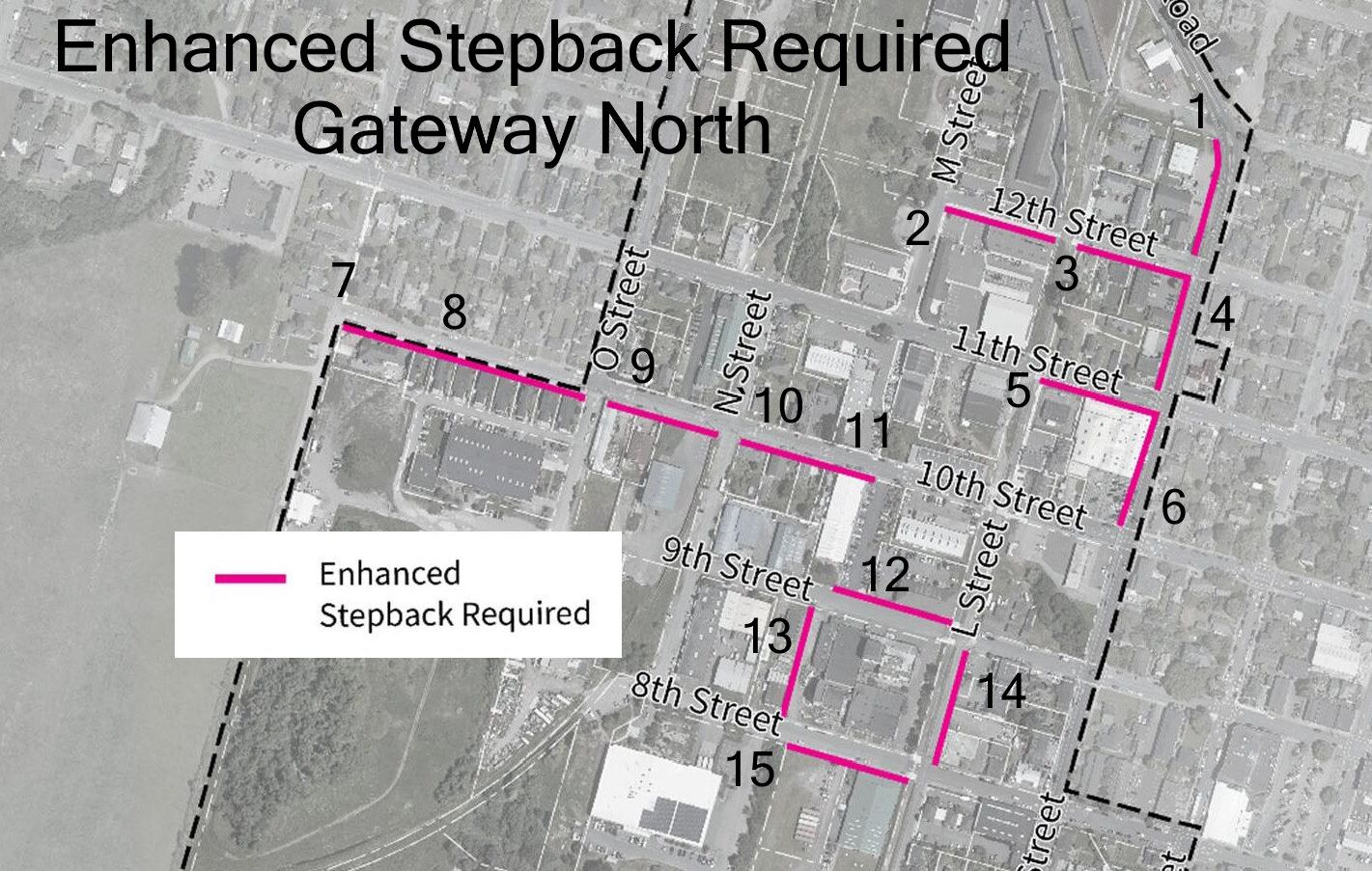
South: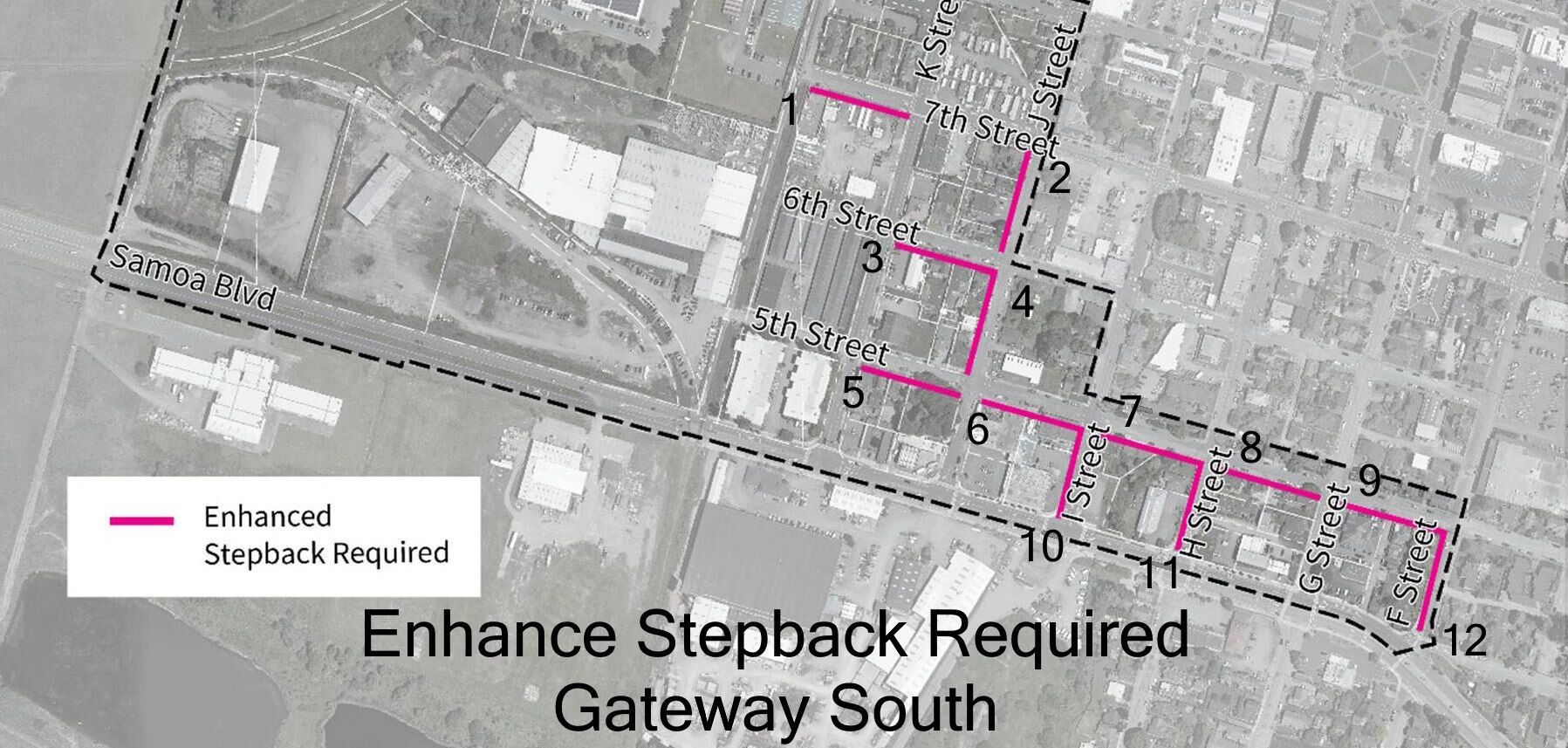
Here’s what the draft Gateway Code tells us about the purpose of the enhanced upper-story step-backs:
“These enhanced requirements are intended to reduce shadow impacts and provide context‐ sensitive massing adjacent to lower‐intensity residential uses.”
By that statement we infer that the purpose is to protect the “blue-sky” views and solar access for the occupants of existing homes and apartments located across the street – and to keep those people from feeling overwhelmed by a large-massed building just 60 or 70 feet away.
The first question that comes up when looking at this map is: How were these locations selected?
Many choices are obvious and clear. Such as requiring enhance stepback on the AmeriGas site, on the south side of 7th Street between K Street and “L Street.” But some of the selections don’t make a whole lot of sense – particularly out on the Gateway “panhandle” – that little one-block and two-block deep, five-city block size extension that runs from J Street to F Street, along 5th Street. And other locations where the enhanced stepback requirement designation is absent, and would greatly help the neighbors.
Some communities have incorporated the 45-degree daylight plane for new construction that is adjacent to historic buildings single-family homes, or – very important – public open space. Here in Arcata, the sun sits low in the sky for much of the year. A 45-degree daylight plane would be very welcome for the public.
“The relational height limit is controlled by a 45-degree slope originating at a height of 15 feet along the applicable property line (creating a 1 to 1 height to setback ratio) as shown in the diagram below.”
Upper-story stepbacks adjacent to Public Open Space,
Historic structures, and single-family homes.
In the current Gateway Code, there are locations for one side of a block being set for an enhanced stepback requirement in 27 locations. I went through them, one by one, to see if for that specific block in that specific neighborhood, the enhanced stepback requirement is appropriate, not necessary, or should perhaps be on both sides of the street. And there are locations where the enhanced stepback requirement is missing.
North Gateway
Note: Where actual streets do not exist (or in the case of “L Street” where there will be a linear park), the name of the street that would be in that location is written with quotes around the name.
The phrase “historic house” is not meant to mean that it is a registered historic house; only that appears to be a house built prior to 1920 or so.
- K Street, west side, between 12th and 13th Streets, where K Street merges into Alliance Road. Fronts Rich’s Body Shop, other auto shop. Across the street from one-story single-family homes. This is the border of the Gateway area. Enhanced stepback is appropriate.
- 12th Street, south side, between M Street and the “L Street” linear park. This fronts the back side of the EdgeConneX data center. Enhanced stepback not likely to be utilized at this site – that ship has sailed, unfortunately. Across the street from a one-story duplex and the entrance to Arcata Mini-Storage.
- 12th Street, south side, between the “L Street” linear park and K Street. Single family homes on both sides of the street, with “The Palms” 8-plex on the corner at K Street, with a windowless side of the building on 12th Street. If there is to be enhanced stepback requirement on the south side, it should also be on the north side. Suggest enhanced stepback requirement on south and north sides.
- K Street, west side, between 11th and 12th Streets. Fronts “The Palms” apartments and goes down to the 1920-era Duchy’s Pizza at the corner of 11th. This is the border of the Gateway area. Enhanced stepback is appropriate.
Missing is enhanced stepback requirement for the former Cahill’s Patriot gas station at 11th and K. This site faces or backs up to one-story homes or structures on all four sides. It should have enhanced stepback requirement, particularly along the back. While this site is just 0.21 acres (9,226 sq.ft.). While it is not likely that a 3- or 4-story building will be built on this site, it is possible. The Commissioners can refer to arcata1.com/mio-seattle-density-205-units to see a 41-unit 4-story apartment building – with 8 parking spaces — constructed on 8,709 square foot lot.
- 11th Street, south side, between the “L Street” linear park and K Street. The Clothing Dock corner. Across the street is the small Duchy’s Pizza house and currently three one-story houses. Within the timeframe of the Gateway Area Plan, the Clothing Dock / German Motors may be redeveloped. Enhanced stepback requirement is appropriate at this location.
- K Street, west side, between 10th and 11th Streets. Fronts the Clothing Dock / German Motors building and the parking lot. This is the border of the Gateway area. Across the street are one-story houses. Enhanced stepback requirement is appropriate at this location.
- 10th Street, south side, between Q Street and “P Street.” Sections 7 and 8 front seven recently built smaller one- and two-story homes and the Little Learners pre-school on the corner at Q Street. Across the street are ten one-story homes. This is the border of the Gateway area. It is not clear what redevelopment might occur – perhaps the Little Learners site would be redeveloped. Enhanced stepback requirement is okay to leave in place.
- 10th Street, south side, between “P Street” and O Street. See #7, above.
- 10th Street, south side, between O Street and N Street. Fronts commercial and industrial buildings, on sites that are underutilized. Across the street from one two-story historic house, one small house, and the rear side of the Hilliard building with commercial office space. Enhanced stepback requirement is appropriate at this location.
- 10th Street, south side, between N Street and “M Street.” Fronts on one-story older homes and the back (10th Street side) of the two-story Holly Yashi building. Across 10th Street from a small house, a multi-unit two-story house, a small apartment, and the YouthAbility Thrift Store that is part of the building where Brio Bread is on 11th Street. If there’s going to be protection one side, it should likely be on both sides of the street. Suggest enhanced stepback requirement on south and north sides.
- Part of #10. 10th Street, between N Street and “M Street.” See #10, above.
- 9th Street, north side, between “M Street” and “L Street” linear park. Fronts to the Northcoast Children’s Services building and Cottage Salon (the little purple house). Across the street from the Arcata Playhouse and the Creamery building. This enhanced stepback designation for construction on the north side of 9th Street seems intended to protect the Creamery building. Development in this location is not likely. No harm in leaving enhanced stepback requirement in place.
- 13.“M Street,” west side, between 8th and 9th Streets. Small shops and storage buildings, slated to be removed and re-developed. Across the “street” from the west side of the Creamery building. Enhanced stepback requirement is appropriate at this location.
- 14.“L Street,” east side, between 8th Street and 9th Street. Fronts the Thom Payne building, Pacific Builders, an empty lot used for parking, and the Barsanti Dentist building and apartments. Across the street from the east side of the Creamery building, including The Pub. Fronts along the L Street corridor linear park. Enhanced stepback requirement is the minimum requirement for this location. Stronger enhanced stepback with 45-degree daylight plane should be designated for all parcels on both sides of the “L Street” corridor linear park.
- 15.8th Street, north side, between “M Street” and “L Street” linear park. Fronts the Tomas / Open Door offices building and the empty lot where the circus tent comes to. Enhanced stepback requirement is appropriate at this location. Given that redevelopment of the back of Creamery and west of the Creamer are likely, enhanced stepback requirement may be on the south and north sides of 8th Street.
South Gateway
- 7th Street, south side, between the “L Street” linear park and K Street. Fronts on the AmeriGas site. Across the street from the four historic Devlin Cottages on 7th Street. This is a crucial location for enhanced stepback requirement. The Commission may want to consider the stronger enhanced stepback with 45-degree daylight plane on the north side of 7th Street here, so that a 5-story building does not overwhelm the small single-family historic homes on the north side of 7th Street, and so those homes can get some south-facing blue-sky view.
- J Street, west side, between 6th Street and 7th Street. Fronts on existing multi-unit houses and small 4-unit apartment. At the boundary of Gateway area. Appropriate location for enhanced stepback required.
- 6th Street, south side, between K Street and J Street. Fronts the side of Rock Solid 4×4 repair and three two-story residences. Across the street from Arcada (two-story commercial building) and three smaller homes. Appropriate location for enhanced stepback required.
- J Street, west side, between 5th Street and 6th Street. Fronts on existing two houses and Redwood Automotive repair shop. Appropriate location for enhanced stepback required.
- 5th Street, south side, between K Street and J Street. Fronts on two houses, a narrow smaller apartment building, and Café Mokka / Finnish Country Sauna and Tubs in a tree-covered setting. Across the street from the side of the former St. Vinnie’s thrift store – 0.43 acres and almost certainly to be redeveloped. Potential building height is five stories. Also across the street from a small apartment building (3 or 4 units) and the side of the house on J Street. Note: The Enhanced Stepback Requirement needs to be on north side of 5th Street. We need to protect Café Mokka and the existing houses – it’s not that the St. Vinnie’s site needs to be protected from them.
- 5th Street, south side, between J Street and I Street. Fronts Industrial Electric and Auto Body Express. Across the street from Neely Automotive, and empty lot, and a historic two-story house. I propose both sides of the street will have redevelopment, and both sides of the street should have enhanced stepbacks.
- 5th Street, south side, between I Street and H Street. Fronts a large older home and a lot that has Jolly Giant Creek running through it. The lot has frontage on 5th, H, and Samoa. On Samoa the lot is in-between what used to be V&N Burger Bar and West Coast Plumbing Supplies. Both are now cannabis dispensaries. On this lot on H Street is a one-story single-family residence. It is doubtful that anything could be built on this lot – the Community Development Director could tell us more. Across the street is the two-story flat roof Fairview Apartments that fronts on H Street and looks to be about 24 units, plus a wide parking lot entrance. The Fairview Apartments are just north of the border of the Gateway Area. There seems no purpose to this Enhanced Stepback Requirement block, but it also does no harm.
- 5th Street, south side, between H Street and G Street. Fronts three large historic homes, divided into units and at least one office space. The buildings and lot across the street may be redeveloped – the north side of 5th street is outside the Gateway area. There seems no purpose to this Enhanced Stepback Requirement block, but it also does no harm.
- 5th Street, south side, between G Street and F Street. Fronts the side of Ken’s Auto Parts and two small single-family homes. Across the street from four small single-family homes, including the “old gas station” home on G Street at the SE corner with 5th. The north side of 5th Street is outside the Gateway area. There seems no purpose to this Enhanced Stepback Requirement block, but it also does no harm.
- I Street, west side, between 5th Street and Samoa Boulevard. Fronts Auto Body Express, and the block of commercial buildings (Masaki’s Restaurant, now closed), with the Northcoast Environmental Center office and Richards’ Goat Tavern in the Cooper Building on the corner. Across the street is the parking lot for the old V&N Burger Bar (now a cannabis dispensary) and a two-story multi-unit historic house. I propose the old V&N Burger Bar and parking lot may be redeveloped and that both sides of the street should have enhanced stepbacks.
- H Street, west side, between 5th Street and Samoa Boulevard. Fronts the former West Coast Plumbing Supplies, now a cannabis dispensary, and a single-family home. The home is on an odd-shaped lot that has Jolly Giant Creek on it. See #7, above. Across from one single-family home, one two-story multi-unit home, and the corner lot of Arcata Used Tires and Wheels. The corner lot or the entire Arcata Used Tire building may be redeveloped. I propose that both sides of the street should have enhanced stepbacks.
Note: G Street between 5th and Samoa Boulevard has no Enhanced Stepback Requirements. - F Street, west side, between 5th Street and Samoa Boulevard. Fronts two houses, one actual historic two-story house, a half-block deep lot with a small house deep on the lot, and a small house on the corner of Samoa that is an office. This is the eastern boundary of the Gateway Area. Across the street from four small houses. Suitable to have the enhanced stepbacks, because of potential construction,
Missing sections of Enhanced Stepback Requirements
Some of these were covered above, and some fresh to this section.
- Enhanced stepback requirement for the former Cahill’s Patriot gas station at 11th and K. This site faces or backs up to one-story homes or structures on all four sides. It should have enhanced stepback requirement, particularly along the back. While this site is just 0.21 acres (9,226 sq.ft.). While it is not likely that a 3- or 4-story building will be built on this site, it is possible. The Commissioners can refer to arcata1.com/mio-seattle-density-205-units to see a 41-unit 4-story apartment building – with 8 parking spaces — constructed on 8,709 square foot lot.
- Stronger enhanced stepback with 45-degree daylight plane should be designated for all parcels on both sides of the “L Street” corridor linear park. If the Commission determines that this is not necessary, there will be a strong recommendation from the community for this to occur. The quality of the “L Street” corridor linear park will be severely compromised if it a “blue sky” view is blocked. If you disagree with me on this, let’s talk.
- Consider similar protection with 45-degree daylight plane stepbacks for the west side of “N Street” from 11th to 16th to protect the N Street linear park that is intended for the railroad right-of-way there.
- M Street, west side, between where 13th Street would be (south of Bug Press) to 11th Street. This is across the street from four one-story single-family homes. It seems likely that the west side of M Street will be developed. This is the Hub district, where building heights can be up to 6-stories. A six-story building on the west or south-west sides of these homes would dwarf them and cut off much skylight. This is crucial. Consider also a stronger enhanced stepback with 45-degree daylight plane on the west side of M Street for these two blocks.
Commissioners, please note: While there are single-family homes scattered throughout the Gateway area (there are about 102 houses there), there are not many locations where single-family homes are directly adjacent to a parcel where a large building might be constructed. One spot is where the Devlin Cottages are – to the north side of the AmeriGas block. And this section on M Street is another location.
- Number 1 on the South Gateway map. 7th Street, south side, between the “L Street” linear park and K Street. Fronts on the AmeriGas site. Across the street from the four historic Devlin Cottages on 7th Street. This is a crucial location for enhanced stepback requirement. The Commission may want to consider the stronger enhanced stepback with 45-degree daylight plane on the north side of 7th Street here, so that a 5-story building does not overwhelm the small single-family historic homes on the north side of 7th Street, and so those homes can get some south-facing blue-sky view.
- Number 5 on the South Gateway map. 5th Street, south side, between K Street and J Street. Fronts on two houses, a narrow smaller apartment building, and Café Mokka / Finnish Country Sauna and Tubs in a tree-covered setting. Across the street from the side of the former St. Vinnie’s thrift store – 0.43 acres and almost certainly to be redeveloped. Potential building height is five stories. Also across the street from a small apartment building (3 or 4 units) and the side of the house on J Street. Note: The Enhanced Stepback Requirement needs to be on north side of 5th Street. We need to protect Café Mokka and the existing houses – it’s not that the St. Vinnie’s site needs to be protected from them.
- Number 6 on the South Gateway map. 5th Street, south side, between J Street and I Street. Fronts Industrial Electric and Auto Body Express. Across the street from Neely Automotive, and empty lot, and a historic two-story house. I propose both sides of the street will have redevelopment, and both sides of the street should have enhanced stepbacks.
- Number 10 on the South Gateway map. I Street, west side, between 5th Street and Samoa Boulevard. Fronts Auto Body Express, and the block of commercial buildings (Masaki’s Restaurant, now closed), with the Northcoast Environmental Center office and Richards’ Goat Tavern in the Cooper Building on the corner. Across the street is the parking lot for the old V&N Burger Bar (now a cannabis dispensary) and a two-story multi-unit historic house. I propose the old V&N Burger Bar and parking lot may be redeveloped and that both sides of the street should have enhanced stepbacks.
- Number 11 on the South Gateway map. H Street, west side, between 5th Street and Samoa Boulevard. Fronts the former West Coast Plumbing Supplies, now a cannabis dispensary, and a single-family home. The home is on an odd-shaped lot that has Jolly Giant Creek on it. See #7, above. Across from one single-family home, one two-story multi-unit home, and the corner lot of Arcata Used Tires and Wheels. The corner lot or the entire Arcata Used Tire building may be redeveloped. I propose that both sides of the street should have enhanced stepbacks.
“On a development site that occupies a complete block face, a new alley must be established to provide vehicle access. In such a case no other curb cuts are permitted.” This is on page 52. (Bold added.)
Does the Planning Commission want to retain this requirement? That the complete-block parcels – the ones that have streets on four sides, that is – must have a new alley on them?
Does the alley have to go all the way through, from one street to the next, or can it be like a stub, perhaps one-half or one-third of the distance into the alley, like a driveway.
We will note that with the two complete-block sites chosen for site testing in the Urban Field Studio report, they did not show an alley there. That is to say, the Urban Field Studio site testing did not follow the Gateway Code. This is also not shown on the Gateway Code 3D build-out images, as noted above. This “a new alley must be established” clause has been in the Gateway Code since the first draft.
What blocks in the Gateway area would have this requirement?
There are not very many of these. The “complete block face” parcels are:
- Site of two metal warehouse-type buildings. Between Samoa Boulevard and 5th Streets, between K Street and the L Street corridor linear park. Faces on K Street and Samoa Boulevard.
- Bud’s Mini-Storage. Between 5th and 6th Streets, and between K Street and the L Street corridor linear park. Faces on K Street.
- AmeriGas. Between 6th and 7th Streets, and between K Street and the L Street corridor linear park. Faces on K Street.
- The south and west sides of the Arcata Trailer Court block — Seventh Street between J and K, and K Street between 7th and 8th — are block-long faces. Putting a through alley there to run from 7th to 8th might be possible, going through a separate parcel on 8th Street.
- The EdgeConneX data center block. Between the L Street corridor linear park and M Street, between 11th Street and 12th Street. Faces on 11th Street. Not likely to be redeveloped in next 20-30 years, but could be at some point.
- The car wash site. Between 9th and 10th Streets, and between K Street and the L Street corridor linear park. Faces on K Street. The alley requirement will need to be removed because the block-size parcel is split by Jolly Giant Creek.
- The Creamery block. Existing building; not applicable. Not likely to be redeveloped – we hope.
Question: When the master plan for the southern section of the Barrel district is created, there will be new streets. In that master plan area right now there is one large parcel to the north of the railroad tracks, and four parcels from the tracks south to Samoa Boulevard. (Plus two left-over triangles that will be combined with the larger parcels.) There may be lot-splits involved in the master plan, particularly if the new Barrel district public 1-acre “square” is deeded to the City and not kept as a privately-owned publicly-accessible park.
When the new streets are laid out, will this create “complete block face” blocks? Will each of them be required to have an alley?
From pages 53 and 54.
“1. Types of Bicycle Parking
a. Short‐Term Bicycle Parking. Short‐term bicycle parking provides shoppers, customers, messengers and other visitors who generally park for two hours or less a convenient and readily accessible place to park bicycles.
b. Long‐Term Parking. Long‐term bicycle parking provides employees, residents, visitors and others who generally stay at a site for several hours or more a secure and weather‐protected place to park bicycles.
- Bicycle Parking Spaces Required. Short‐term and long‐term bicycle parking spaces shall be provided as specified in Table 2‐34.
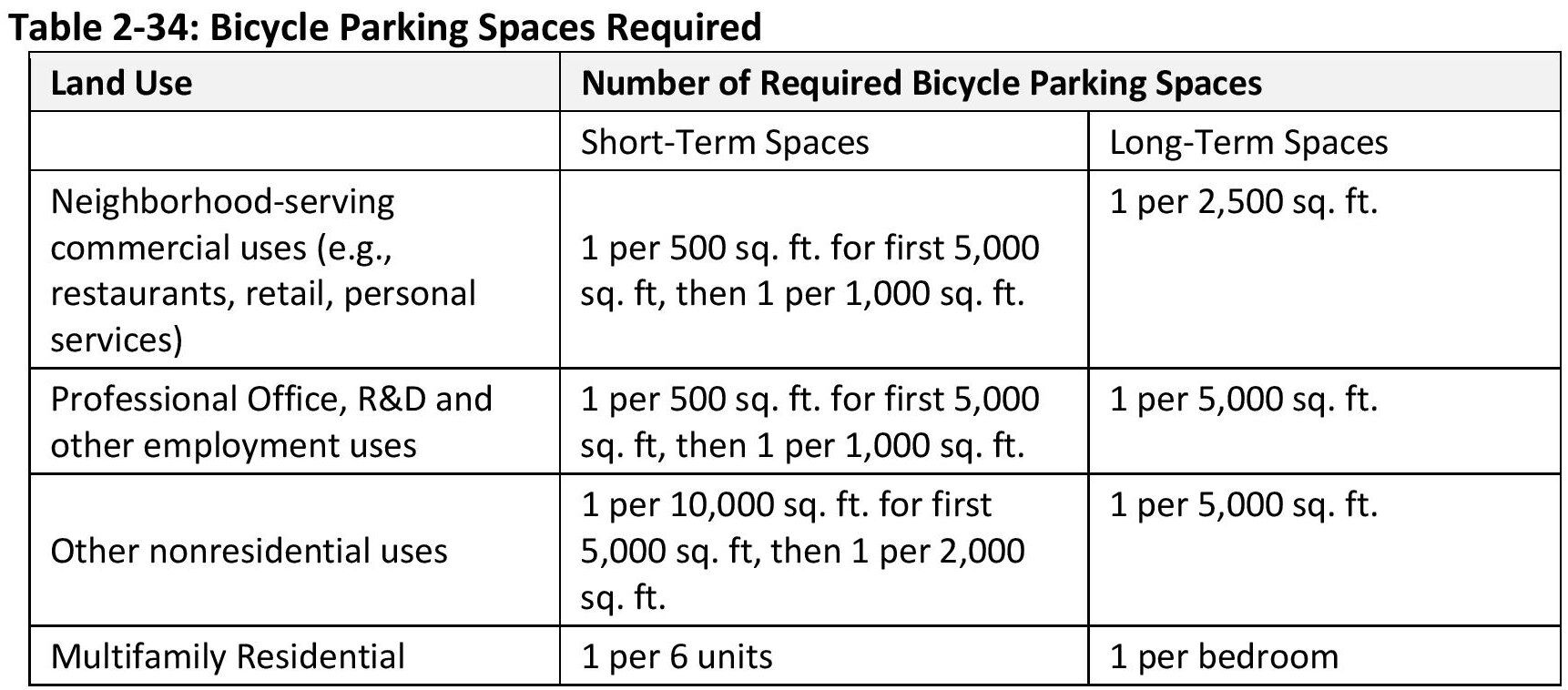
Note: Under “Other nonresidential uses” it should read 1 per 1,000 sq. ft. – not 1 per 10,000.
Critique
- Let’s say we’ve got a “neighborhood‐serving commercial use” – a restaurant. The space is 1,000 square feet – about 25 feet by 40 feet, the size of a Sunny Brae three-bedroom house. It’s got tables that will hold about 30 diners at a time, and there’s a staff of five people. The diners stay for less than two hours, and the staff stays for 6 or 8 or 10 hours.
By this chart, the required number of bicycle spaces for staff is shown as a required minimum of 1 per 2,500 square feet. So those 5 staffers get one space.
For the short-term bike spaces, the chart shows 1 per 500 sq. ft. for first 5,000 sq. ft, then 1 per 1,000 square feet. We’ve got 1,000 sq.ft., so the required minimum number of bike parking spaces is 2. Our 30 diners have two parking spaces – total.
- Suppose we have a larger restaurant – 2,500 square feet. To put this in perspective, Arcata’s D Street Neighborhood Center is 2,500 square feet. It will hold 140 people at one sitting for dining. We’ve all been there, so we know what it’s like when the hall is filled with people.
For those 140 diners, let’s say we have 15 servers and staff.
At 2,500 square feet – the size of the D Street Neighborhood Center – those 140 diners will see just five bike parking spaces. The 15 staffers get one space – a single bike parking space.
- Let’s say you have an accounting firm, or a small light-manufacturing operation – making jewelry, perhaps. Or making cannabis gummies, or silk-screening hoodies. It doesn’t matter. A year ago you had 20 employees working for you and now you have 30. Your landlord offers you a 1,000 square foot space, then a 2,000, and then a 5,00 square foot space. And that doesn’t matter either – not for bike parking for your employees. Because according the Table 2-34, your landlord needs to supply you with only one bike parking space for your 30 employees. For your non-existent short-term spaces, you’ll have 1 or 2 or even 5 bike parking spaces.
- For apartments, having a minimum of one bicycle parking space per bedroom is good. I’ll make two suggestions. 1) The Commission may want to add a footnote to this table to make clear that for purposes of calculating minimum bike parking required, a studio apartment is considered to be one bedroom. 2) For student-oriented housing in which there may be two or three beds per bedroom, the calculation might be based on the number of beds, not bedrooms. While family-oriented housing might have more than one bed per bedroom, student-oriented housing is designed from the start to definitely have more than one bed per bedroom – and should be differentiated as such.
Bottom line:
- This table of minimum required bicycle parking spaces is sending the wrong message. We want to encourage bicycle use in Arcata – ride your bike to a restaurant; biking to work. Building new housing based on these figures for required bike parking does not offer this encouragement.
- Whoever made up this table did not think things through very well.
- The Planning Commission can do a better job than what’s here.
- Long-term bike parking is said to require a “weather-protected place.” That needs to be better defined. As we’ve recently seen, a developer believed that bicycle parking under a flight of stairs is “weather protected.” The Commission should decide if bike storage should be required to be in a sealed room, or whether under an awning or a carport is sufficient.
- The Code should contain provisions for electrical power for charging.
There is no mention of electric bike charging. - The bicycle owner should not be required to lift the bicycle in order to put it on a rack or hook for storage.
- Under security for long-term bicycle storage, the Gate Code offers four options.
In a locked room or area enclosed by a fence with a locked gate;
Within view or within one hundred feet of an attendant or security guard;
In an area that is monitored by a security camera;
Visible from employee work areas.Of these four options, I propose that storing bicycles in a locked room provides security. “Visible from employee work area” does not provide security.
Providing parking within 100 feet of an attendant or guard – not sufficient security there either. And the Gateway Code’s expectation is that there will be an attendant present and alert for 24 hours a day, a not-very-likely scenario. The Code also does not specify anything other than “within one hundred feet.” The “attendant” might be an on-site manager in a closed-door office near the building’s entrance, and the bikes could be outside under a carport structure, 100 feet away.
A security camera does not provide security against theft. It only shows what time the theft happened and what the thieves were wearing.
Again, the Commission can do better than this.
On Page 61, under “Tiers” it is written:
“The community benefit program utilizes a tiered incentives system where projects that provide higher levels of community benefits are permitted greater intensity.”
(Note: Typographical error on “benefit” – should be plural, as “benefits.”)
The Community Benefits program does not “permit greater intensity.” The Gateway Code has no upper limit on the number of units per acre that a developer can build.
The same phrase is used in the Gateway Area Code, page 50.
Community Benefits points are required if a project is going to be anything taller than four stories.
The Community Development Director can provide more clarity on this, and perhaps arrive at better wording for this part of the Gateway Code.
Carpools, page 52. “Non‐residential uses shall provide designated carpool/vanpool spaces as shown in Table 2‐33.”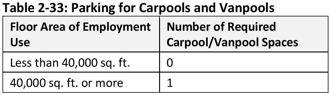
First of all, I don’t believe we want a non-residential building that’s 40,000 square feet in the Gateway area. That would be a four-story office building, or a half-acre-size light-manufacturing operation.
Second, as the table shows, if the floor area of employment use is under 40,000 square feet, then no carpool parking is required. Since in Arcata an office or light-manufacturing operation that is 5,000 or 10,000 or even 20,000 square feet is far more likely, the table is no needed at all.
Third, a 40,000 square foot non-residential building might have 60 or 80 employees. According to the Gateway Code for off-street parking (page 51), a 40,000 square foot office can have a maximum of between 40 and 80 parking spaces, depending on the district. (In the Corridor district, it’s one parking space per 500 sq.ft. = 80 spaces.) Parking for a carpool vehicle can be provided by those 40 to 80 spaces.
Suggestion: This is another example of a Gateway Code policy that was not well thought-through. I regard it as a hold-over from large-city orientation. In my view, it does not relate to the Gateway Area Plan. This table for 0 or 1 carpool/vanpool can be removed.
“Ground‐Floor Residential Openings. A minimum of 20 percent of a ground‐level residential building wall that faces and is within 20 feet of a public sidewalk, street, pathway, or right‐of‐way shall be comprised of entries, windows or glazing, and/or railings. Trim, including window shutters, is counted towards meeting this requirement. Garage doors are not included.”
Page 41. Why are trim and shutters counted toward the 20% transparent openings? An unscrupulous developer could put in small windows and big shutters. This defeats the intent of the policy. Suggest: Change to: “Trim, including window shutters, is not counted towards meeting this requirement.”
Page 35 is the start of a segment on Façade Articulation.
“A project must incorporate at least two of the following façade articulation techniques on each building frontage that faces a public street, right‐of‐way, or publicly accessible path:” followed by a list of 15 items.
“h. Projecting Window Frames. Projecting window frames where the depth of the frame must exceed the minimum dimension in Paragraph H (Windows) by at least 50 percent.”
-
- Subsection H – Windows (It’s not “Paragraph H” – on page 42) specifies minimum standards for trim width — only 1.5”, which seems too narrow – and for recessed windows. There are no dimensions listed for projecting window frames.
“k. Awnings and Canopies. Awnings and canopies that exceed minimum dimensions in Subsection F (Building Entries) by at least 50 percent.”
-
- As described in the section on the pedestrian realm dimensions above, an awning or canopy can extend out over the sideway area. The minimum dimension is 4 feet, so a 50% increase would be 6 feet. That distance goes onto the sidewalk zone.
“o. Rounded Corner Treatment. A rounded corner treatment for the full height of the building at the intersection of two streets.” I believe we know what “a rounded corner treatment” means, but it’s not specified. Would rounding off a corner to a radius of 1/2” or 1” qualify – like a bullnose finish?
“i. Contrasting Material and/or Color. Variation in two of the following: exterior material, material size; texture and pattern; color.
This seems like an invitation to bad design The developer may include a hodge-podge of colors and materials to satisfy this option.
Suggest: The Commissioners take a look at this list and revise as desired.
“Page 44. Exterior timber shall be protected from decay by one or more of the following:
-
-
- Material properties (e.g., cedar).
- Staining and sealing.
- Painting.”
-
Exterior timber is not “prevented from decay” by virtue of it being cedar or redwood. Using cedar and redwood is a good thing, but the wood still does need to be protected. Suggest: Change item 1 to “1. Material properties (e.g. cedar), adequately stained or sealed.”
The Gateway Area Plan calls for “Form-based code standards for green buildings, electric vehicle charging, rainwater management, and incentives for open space, creek daylighting, and community gardens.” (Page 34.)
There is nothing on standards for electric vehicle charging or community gardens in the Gateway Code.
Why are there no standards for bus pullouts?
In a finer-grained form-based code, the City would have identified proper locations for bus-stop pullouts and offered community benefits points for those specific parcels.
If a developer was looking to create a commercial center, a bus stop would be desirable. The car wash site would be ideal.
Fred Weis: Comments, suggestions, and requests
I do not believe that it does. As one example of many, the Code allows street-facing garage doors for multi-residential buildings (i.e. apartments). See here for details — there can be six single-car garage door openings on a single city block. The Planning Commissioners have specifically said that they do not want to have garage doors facing a street.
Yet this section of the Gateway Code, which was in the first draft, has persisted completely unchanged in Draft #2 and now in Draft $#3.
See pages 6 and 7, e. Highlights added. An administrative hearing can be with the Zoning Administrator or with the Planning Commission. In the current Gateway Code, a project of under 30,000 square feet would not require an administrative hearing.
As a reference, the Plaza Point building, across the street from the Co-op, the SE corner of 8th and I Streets, is 30,371 square feet. By this table, a project just slightly smaller than Plaza Point would not go to the Planning Commission, and would not even be brought to at a public hearing.
“e. Administrative Hearing.
-
- When required by Table 2‐19, an administrative hearing shall be held at the date, time, and place for which notice was given.
- After receiving comment and considering the proposed project, the review authority must either approve the application, deny the application, or continue the hearing to a future date.
- The hearing may be continued only if additional information is needed to determine project conformance with objective standards. A hearing may be continued one time after which the review authority must render a decision.
Items 2 and 3 are a simplification of the State streamlining requirements – in my view, this is a too-simplified account. My concern is that by not bringing adequate information to the first meeting, and then bringing, say, half of what’s required to the second meeting, a developer would force the Zoning Administrator or the Planning Commission to render a decision. An evaluation of what “additional information” is may be taken to be a subjective decision, and thus not legally acceptable as criteria in the decision process.
- As this is a form-based code, it would be useful to have the definitions of the terms use shown as diagrams.
Such as this diagram from another form-based code. 
These drawings, as simple as they are, are not as clear as they should be. One of the advantageous features of a form-based code is that it uses images to convey information. Therefore the images should be accurate and convey the information appropriately.
I believe these drawings should be improved. As isometric drawings that are intended to convey information, they rate a B-, or C+. This is what’s wrong:
- The width of dimension “D” does not match the width of the stepback that it’s intended to illustrate. In addition to where it is, “D” should also be placed on the portion of the building closest to the street – as that’s the focus of the upper-floor stepback.
- Why Tier 4 (the 7th story) is stepped back from the 6th story is not explained in this drawing. On the Building Massing Table, it shows that the 7th floor has a floor area not greater than 60% of the ground floor. There is no reference to that in this drawing.
- Dimension “B” is the maximum height. This drawing shows “B” stacked over the minimum height “C” — It looks as though “B” is the additional height, not the total height. B should instead be placed in the same height-line as A.
- In the isometric drawing, the lines showing the depth of the stepback exactly match the lines that show the height of each floor. The coincidence of the step-back width matching the floor height lines makes for a drawing that cannot easily be understood — it’s like an optical illusion. This is a poor choice on the part of the person who made the drawing, and one that is very easily corrected.
- The drawing would be much improved if it used different line widths. The exterior corners of the building should have a more bold outline.
A close-up of the above image to illustrate the points above:
Here is an improved drawing. It is not perfect, but is far easier to read and obtain information from than the original drawing.
First, the original. The left side of the building looks as though it could be floating.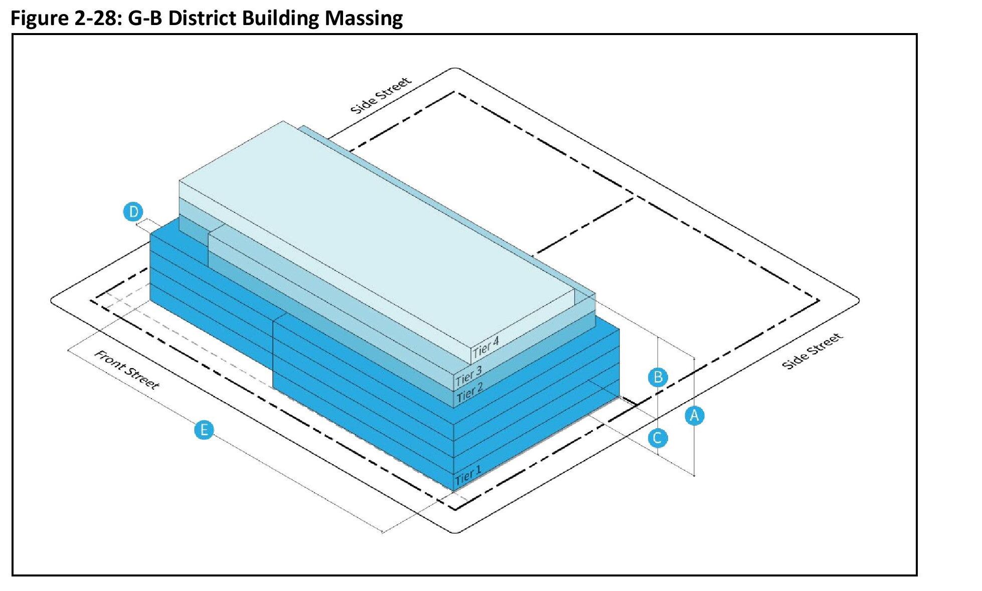
The improved drawing, below. Measurement depictions for B, C, and D are improved also.
Note: This drawing was derived from the existing drawing, to show what an improved isometric drawing could look like. The upper-story stepback depth is increased, and the street setback is decreased — so the setback from the street is not accurate. To be used in the Gateway Code, this figure would need to be re-drawn.
- A form-based code does not prevent bad design. If the Planning Commission wants or does not want certain styles of design, the Gateway Code has to be specific.
The Gateway Code can be as specific as the Planning Commission wants it to be.
The Gateway Code now does not require a minimum density per acre – only that residential use must be at least two thirds of the floor area of the project. (Page 4.)
Much of the discussion has been to promote a developer who is seeking higher density. The Community Benefits program supports higher-density housing. But what if a developer designs a project that is cost-effective (for the developer) at a far lower density? Are we willing to accept a block or two of the Gateway Area built with the rows of one-bedroom apartments in two-story buildings — the type of housing that we now see on the Foster Avenue Extension, or, worse, a version of the recently-approved Arcata Garden Apartments?
The question is: What can we do to ensure that we do not design that is not what we want to see in the Gateway area.
Let’s use the AmeriGas site as an example. The AmeriGas site is what can be considered as a premier site in the Gateway area. It is a central, full-block parcel.
I am asking you to use your imagination on this. I assume the Commission and the Council recall the site design of the Westwood Garden Apartment project. It has long rows of one-bedroom apartments. While the building is two stories in height, the ground-level for the majority of the buildings consists of parking stalls.
The Gateway Code allows a Base Tier building height of two stories. (Page 20.) A State Density Bonus waiver for offering 20% low-income (subsidized with grants) student housing allows a waiver on parking maximum. (There are other ways of accomplishing this also.)
What is shown is what could result.
The solid blue lines are the 250’ x 250’ size of an Arcata block. The dotted blue lines show a 20-foot setback. This is larger than what the code requires on 3 sides – the 7th Street side (on the right) faces the Devlin Cottages and requires a 20-foot setback.
What’s shown is:
- 67 one-bedroom apartments
- Each apartment about 395 square feet
- A density of 47 units per acre
- 62 parking spaces
- Parking stalls on the ground level for three of the four buildings
- Commercial spaces on the ground level facing K Street
- No attempt to create an interesting or people-oriented face to the L Street corridor linear park – and a missed opportunity for people-oriented retail and food shops.
- Two-story pitched roof design
I drew this to make a point. It is a crude design. If you don’t like what is shown, keep this in mind: It could be worse than this.
Of the many people who have been involved with the Gateway Area Plan over these past years…
-
- The Community Development Director and staff
- The City Manager
- The Planning Commissioners
- The former Planning Commissioners: John Barstow, Christian Figueroa, Kimberley White, former Chair Julie Vaissade-Elcock, and Judith Mayer
- The City Councilmembers
- The consultants
- The public
… I will propose that no one wants this style of building to dominate the re-development spaces in the Gateway area.
And yet the Gateway Plan will allow it.
(Note: Based on how this is drawn here, there would have to be some design differences, in wall and roof articulation mainly. But the basic “two-story with parking stalls underneath” design could be approved for following the objective standards.)

Suggestion:
If the Planning Commission wishes to take preemptive action to prevent this style of construction from being built in the Gateway area, the Gateway Code needs alteration. If the current consultant cannot take care of this to the Commission’s satisfaction, the City should consider finding and hiring a “fix-it” consultant for the Gateway Code.
The 3D image of theoretical buildings, at the St. Vinnie’s site at 5th and K Streets and nearby, was what the public had as an example of how the Gateway area might get built out.
This design has a gentle slope in the height of the building at the rear of the property, in order to have a smaller effect the neighboring housing. The building as shown is 4-stories tall along K Street, and tapers down to 2-stories and 1-story at the back.
The second image shows the same site with a five-story building that is built to the maximum allowable footprint, per the current draft Gateway Code. It is set back 10 feet from the street, and built right up to the property line at the rear and non-street sides.
We can note that this image does not show the 8-foot-deep upper floor stepback that would be required after the 4th floor. That stepback is required for 75% of the length of the street frontage only. The 5th floor would be required to have a maximum floor area that is 80% of the ground floor area.
Even with the stepback and floor area restrictions, that building could be designed with no stepback at the rear of the building. There could be a 5-story vertical wall, directly on the property line, as the mock-up illustration shows.
The point is to illustrate the effect on the neighbors of having a five-story building that’s built right up to the property line.
My question to you, the Commissioners: Do you feel that that is okay to have a 60-foot vertical wall right on the property line, next to existing one-story and two-story residential buildings?
This is not an argument against five-story buildings. The Gateway Code (form-based code) can be anything you want. It can, if you want, be specific down to the individual parcel or even corner of a parcel.
But what we have is a generic code. It has no regard for existing residential uses on neighboring properties.
Here is a code diagram from Salt Lake City. It shows a setback of 15 feet from an adjacent single-family residence, and a maximum building height of 30 feet as an uninterrupted wall.
Here is a section of the 3D image, from August 2022:
Here is what the Gateway Code allows. (There should be an 8-foot-deep stepback on 75% of the street frontage, as discussed above. No stepback is required at the side and rear of the building.)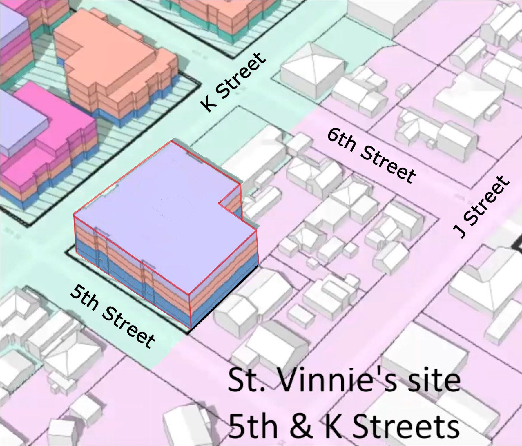
And here are both buildings visible together, so you can imagine the effect the larger building would have on the neighbors.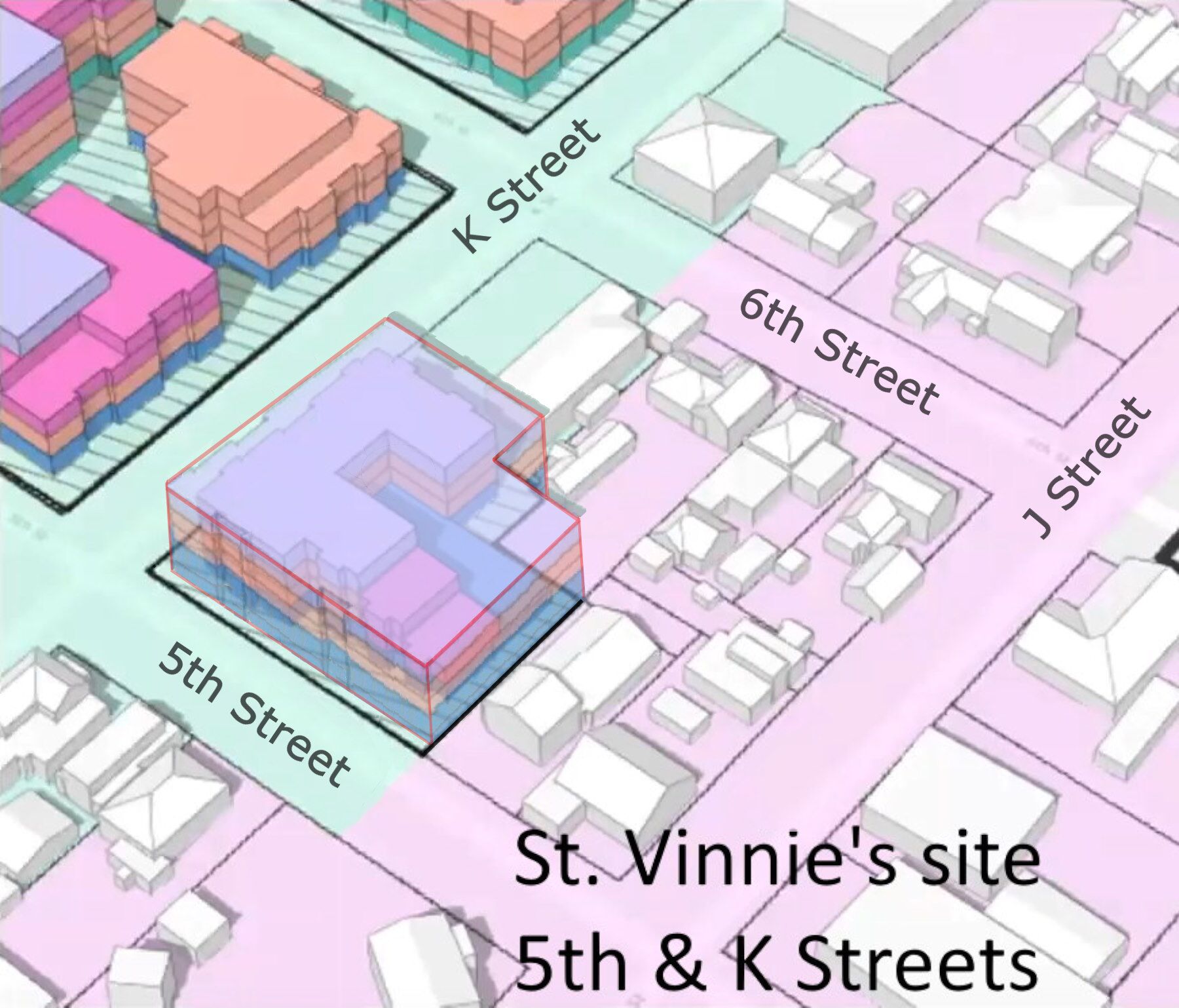
My request:
A form-based code can be as specific as the authors want it to be. It can give guidelines for each block or each parcel, if that degree of control is wanted.
The Gateway Code has four districts, with the different height and parking regulations in some districts. It has the scattered e It does not differentiate between a zero setback in a case where someone else is going to put up a tall building right next door, versus building up to the property line where there are existing neighbors.
I ask you to consider the architectural, aesthetic, solar-shading, and general quality of life issues that occur when a 60-foot vertical wall is located right directly on a property line – with no graduated step backs in the design to let sun and blue sky be a part of that neighbor’s existence.
What do boxy buildings do for a neighborhood?
Here is an image of a five-story building that was built adjacent to existing residences in Portland, Oregon. (The image appears wavy because it is a Google Earth satellite view.) In this case, the residences are much larger than the typical residences in the Gateway area. The 5-story building was not built on the property line – there appears to be a 10-foot setback, with some trees and vegetation as a buffer. You have to imagine the 5-story building being built even closer to the residences.
You can see other photographs of this house and apartment building at arcata1.com/what-does-bad-zoning-look-like
“Rooftop solar energy facilities may project above the maximum building height by up to five feet.” Page 30.
Suggestion: Add language to the effect of: “Roof-top solar energy facility does project above the maximum building height, it shall be placed in a way so that it is not visible from a perspective of a person observing from the other side of the street or similar vantage point. This may be effected by placing the equipment not less than 6 feet from the vertical plane of the exterior wall.”
I suggest similar language be incorporated into the Gateway Code for all solar panel installations, regardless of whether they exceed the height limit. With taller buildings, because of the angle of view from the street, it is not difficult to hide the solar panels.
Having mechanical equipment set back from the edge of a roof is a common requirement in building codes.
Please be aware that a tower or spire can exceed the height limits by 8 feet, and architectural features can exceed the height limit by 3 feet. The Commission may consider removing the monument, cupola, spire, and tower exceptions in the Gateway Code to prevent abuse of the height limit.
See 9.30.040.D.1 (Exceptions to Height Limits) at https://www.codepublishing.com/CA/Arcata/LUC/ArcataLUC0930/ArcataLUC0930.html#9.30.040
 1.“1. Architectural features. A chimney, cupola, monument, mechanical equipment, or vent may exceed the height limits by a maximum of three feet. A spire, tower, or roof-mounted water tank may exceed the height limits by eight feet.”
2.“Telecommunications facilities. The height of communications facilities, including antennas, poles, towers, and necessary mechanical appurtenances shall comply with Chapter 9.44 (Telecommunications Facilities)”
Chapter 9.44 (Telecommunications Facilities) is available here:
https://www.codepublishing.com/CA/Arcata/ LUC/ArcataLUC0940/ArcataLUC0944.html#9.44
Shown: Telecommunications equipment on top of the Humboldt County courthouse building — a tower on top of a 5-story building.
Page 15. Circulation. “ (2) ) The City may approve a Master Plan circulation system that deviates from Gateway Area Plan Figure 8 and Figure 9 upon finding that the deviation allows for superior circulation consistent with Gateway Area Plan goals.”
- “The City may approve a Master Plan circulation system that deviates from Gateway Area Plan Figure 8 and Figure 9… “
I hope they do – I hope the Planning Commissioners recognize that this “plan” was intended from the beginning to only be representative. It is a terrible plan for all kinds of reasons which I’m certain the Commissioners will recognize. It is contrary to many, many design criteria that the Commissioners have spoken of. - In my opinion, it should be the Planning Commission that has the hearings on this updated Barrel circulation plan, makes a recommendation to the Council, and the non-recused Council members who vote on it.
- 3.I’ll include some portions of Figures 8 and 9, below. They are in the Gateway Area Plan, pages 66 and 67.
- We will note that Figure 8, the Proposed Vehicular Circulation plan, is dated 12/19/2023. The City Council determined that the L Street corridor would become a linear park on August 22, 2023 – four months earlier, and eight months ago now.
The map has a designation for “New Shared Street ‘Woonerf’ Concept” in the map key. It shows a Woonerf for a block of 6th Street, between Bud’s Mini-Storage and the AmeriGas site. But it does not show the existence of the L Street corridor Linear Park.
- In my view, the main vehicle entrance (without having to get onto Samoa Boulevard) into the Barrel District housing should NOT be 5th Steet ! This is a recipe for disaster in many ways.
There may be 500, 600, perhaps 1,200 apartment units in the Barrel District one day. The people in cars who want to go right into town, or who want to get onto K Street to go north to Alliance Road, will all be coming out of the Barrel District and all of them will be on 5th Street.
Those cars will be intersecting with the bicyclists and strollers on the L Street corridor linear park. That’s bad. The cars may head down 5th Street – a small residential street – to get to downtown. That’s bad too.
- A possible solution is to require the vehicles to exit onto Samoa Boulevard at where M Street would be. There would have to be traffic lights (timing coordinated) at K, L (for people), and M – arranged as a single traffic signal, essentially.
For walkers and cyclists who want to enter the Barrel District there, there would be Woonerf with bollards (closed to all but emergency vehicles).
- The illustration below of this is NOT a final diagram that I am proposing – just something to get the conversation started. Clearly other roads shown in the Barrel district are not shown.
- Please be aware of the concept and 2-part article “Could Gateway’s Barrel District be 100% free of cars?” arcata1.com/could-gateways-barrel-district-free-of-cars“
I believe it would be possible to have a transit hub in the Barrel district somewhere either central or on the east side and put all the car parking in one area on the west side (near the SoilScape building perhaps). - 6.Other articles on Woonerfs and linear parks and the L Street corridor linear park may be found at arcata1.com/l-street-pathway-and-linear-park-selected-articles
Minor typographical and editing errors
- Page 2, 14
The word “Barrel” is misspelled as “Barrell”– Two locations. - Page 14
“The Barrel District Master Plan mut contain maps….” Should be “must.” - Page 10. Says “The following land uses require a Use Gateway Permit…”
Should be “The following land uses require a Gateway Use Permit…” - On Page 61, under “Tiers” it is written:
- “The community benefit program ….” Should be plural, as “benefits” – with an “s”
- Long‐Term Bicycle Parking Standards, page 54. The list is not numbered correctly. In the Gateway Code document it is displayed as follows.
The list: c. d. e. f. should be: (i) (ii) (iii) (iv)
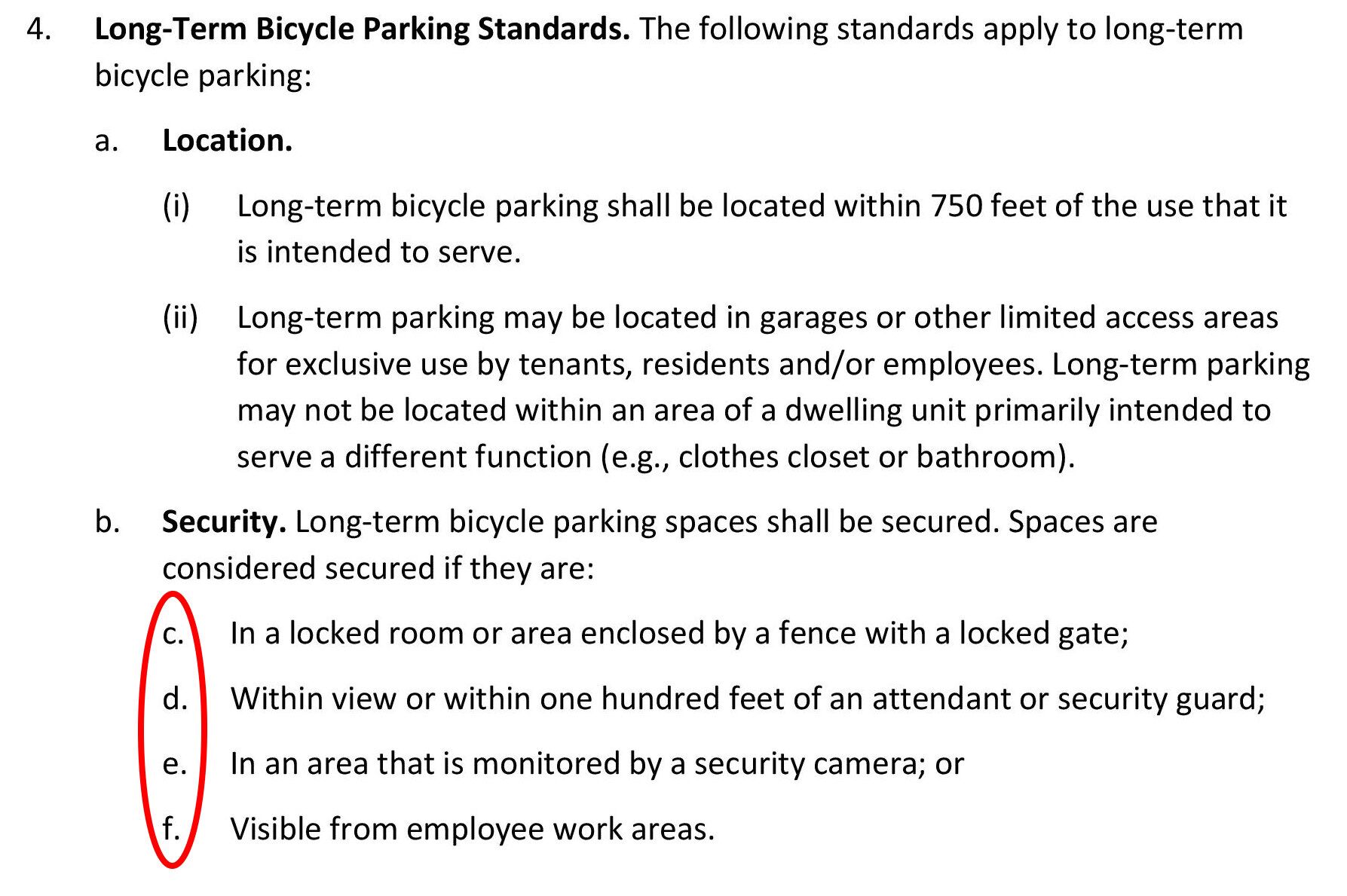
- Page 60.
“d. Service entrances, utility access, or other similar feathers.”
Should be “features.” - Page 38.
“Corner Buildings. A corner building must have an entrance facing both streets or have a single corner entrance accessible to both streets.”Correct to: “A corner building must have entrances facing each street…”
There cannot be “an” entrance (i.e. a single entrance) that faces both streets. - Page 41. Typographical error on Figure 2-50.
“Transparent openings to be 20% or more of the buliding wall area.”
Correct to “building.” - Page 36. “Paragraph H (Windows)” should be Subsection H (Windows)
Other typographical errors are of greater consequence and may cause incorrect interpretation of the Gateway Code. If they are of that level of importance, they are covered in a different section, above.
Appendix
- “Gateway Code form-based code – September 22, 2023 version — What’s changed”
An article from September 24, 2023
Included here is the article from Arcata1.com that outlines the differences between the 1st draft (June 2023) with the second draft (September 2023) of the Gateway Code. The estimated reading time is 15-30 minutes.
On Arcata1.com, this article can be seen here: arcata1.com/gateway-code-sept-22-2023-version-whats-new
This September 24, 2023, article is a blend of factual changes needed and my opinions. There are a few things that I can see now I got wrong in this article, but overall it stands up well.
This article is included here in this document because: From all that is expressed in this article, not a single item was addressed in the 3rd draft, the “Public Review” draft.
The 3rd draft, the “Public Review” draft, contains the same typos and the same errors as the 2nd draft.
Gateway Code form-based code – September 22, 2023 version — What’s changed
September 24, 2023 431 times viewed as of April 19, 2024
Estimated reading time: 15-30 minutes.
Without fanfare or announcement, the second draft of the Gateway Code (form-based code) was released on Friday afternoon, September 22, 2023.
This second draft and the June 5, 2023 draft can both be viewed at The Gateway Code (Form-Based Code) – 2nd draft from Ben Noble, September 22, 2023.
Looking at the changes and updates in the 2nd Draft
We’ll go through the changes and updates in page order. Where there is an update which I consider to be more important, I’ll highlight that in red. You can scan this article for items in red to identify what may be more important.
Many of the changes are administrative details — and can still be important. The more crucial changes in terms of the form-based code are the specifications and determinations that affect planning and building.
What’s disappointing to me is that there are not more changes. The first draft was, in my view, deficient in how Ben Noble viewed Arcata and how that draft of the form-based code might allow us to achieve our goals in the Gateway area. What was missing from that first draft is, essentially, still missing.
This listing may not include all of the changes and updates. If you see other issues or wish to point out specific parts of this code, please contact me.
The L Street Linear Park
With the City Council’s decision that L Street will become a linear park, all references to L Street must be revisited. References to L Street can be found on pages 14, 17, and 50, and added to page 55 as a required Linear Park. In addition — and this is very important — new height, setback, and step-back, and massing considerations need to be looked at for all parcels that abut L Street and the L Street corridor.
The Gateway Code updates and changes
To skip to some important sections:
Page 1
- In the fashion that is typical with documents that come out of Arcata’s Community Development Department, the title page of the June 5 draft had no title, no author, no date, no version number, and no context of what the document is.
The September 22 draft improves a little here, with “Gateway Code Public Version 2.” Still no date, version number, author, or context. We’ll note also that the document does not say DRAFT although we clearly know this as a draft.
- The September 22 draft shows: “- Planning Commission recommendations
incorporated through August 8 2023 meeting date.” But I do not believe that it contains all of the Planning Commission’s recommendations. That can be determined as we carefully look at this document. It is up to the Planning Commission to decide.
Page 2
- 9.29.010 – Introduction. Paragraph F has been added.
This requires the Planning Commission to have a review of the Gateway Code at least every two years, at a minimum. This is not a limitation: The Commission can review the Code or any part of it at any time, as it sees fit.F. Periodic Planning Commission Review. Two years after the effective date of this chapter, or six months after the issuance of a certificate of occupancy for the first project approved pursuant to this chapter, whichever comes last, and then every two years thereafter, the Planning Commission shall undertake a review of this chapter and determine whether to recommend that the City Council amend, modify or delete, in whole or in part, any of its provisions.
- 9.29.020 – Permits and Approvals, B. Gateway Ministerial Permit, 3. Eligibility.
3.a.2. Be built to a density of at least 32 units per acre.
In the June 2023 draft, this was specified as: at least 25 units per acre.
Page 3
- The table for the tiers for ministerial review has not been changed from the June 5 draft.

- c. Environmental Review. Paragraph 3 has been added.
3. If the project site is included on any list compiled pursuant to Section 65962.5 of the Government Code, or is on a local or regional list of hazardous sites and has not received a clearance letter or land use covenant, it is not eligible for a Gateway Ministerial Permit.
Page 4
- d. Public Notice. Item 2, Notice of application for a Gateway Ministerial Permit.
In the June 5 draft, item 2(d) had been:
“The date the Zoning Administrator will render a decision on the application, which shall be not less than 10 days from the date of notice.”Item 2(d) is now (bold added):
“The date the application’s compliance with objective standards required for Ministerial approval may first be considered for Planning Commission public administrative hearing, as required and shown in Table 2.19.”Table 2-19 does not have dates or times on the table.
Table 2-19 is incorrectly referenced. - d. Public Notice. Item 3, Notice of administrative decision. In the June 5 draft, this referred to Section 9.74.020.B.2. In the September 22 draft, the requirements are listed as a to f.
We can note that 3(d) uses the “10-day”language that was removed in 2(d), where 2(d) referred to Table 2-19.
- e. Administrative Hearing. Important
Opinion: This change enables a developer to “game” the system, by purposefully omitting a necessary bit of information at the first meeting with the Zoning Administrator. The developer then supplies this at the second meeting, at which point the Administrator is required to render a decision.In the June 5 draft, Item 3 had been: (highlighting added)
“The hearing may be continued only if additional information is needed to determine project conformance with objective standards. A hearing may only be continued a maximum of three times after which the review authority must render a decision.”In the new draft, the number of times has been changed. (highlighting added)
“The hearing may be continued only if additional information is needed to determine project conformance with objective standards. A hearing may be continued one time after which the review authority must render a decision.”
Page 7
- Table 2-20: Gateway Use Permit Requirements has not been changed.
Should be changed to be consistent with “9.29.020 – Permits and Approval, B. Gateway Ministerial Permit, 3.a.2.” on Page 2:
“To be eligible for a Gateway Ministerial Permit, a proposed project must satisfy all of the following requirements: 2. Be built to a density of at least 32 units per acre.“ We can note that, by this table, a new use of more than 2,500 square feet has the Planning Commission as the review authority, while a residential project that is under 30,000 square feet can go the Zoning Administrator.
Page 9
- C. Prohibited Uses.
June 5 draft, Item 11: “Other similar and compatible uses. See Section 9.29.030.D (Similar and Compatible Uses)” has been removed. Item 11 is implicit in Item D as “Similar and Compatible Uses.” - Table 2-21: G-B District Building Placement
No changes from the June 5 draft.

Page 11
- Table 2-22: G-B District Building Massing
In first grouping “Height,” Tier 1, “Stories, Min.” has been changed from 2 to 3 minimum stories.
In the notes, the June 5 draft had “[1] Minimum height applies only to residential uses.” This has been removed.

Page 12
- The image “Figure 2-28: G-B District Building Massing” shows no change from the June 5 draft. It shows a step-back on the 7th story (Tier 4). In the form-based code, there is no step-back specified for the 7th story.

These drawings, as simple as they are, are not as clear as they should be. One of the advantageous features of a form-based code is that it uses images to convey information. Therefore the images should be accurate and convey the information appropriately.
I believe these drawings should be improved. As an isometric drawing that is intended to convey information, it rates a B-, or C+. This is what’s wrong:
1– The width of dimension “D” does not match the width of the step-back that it’s intended to illustrate.
2– It is showing a second upper-story step-back, with the 7th story (Tier 4). In the form-based code, there is no step-back specified for the 7th story.
3– It shows the maximum height as “B” stacked over the minimum height “C” — It’s not clear whether B is the added height. B should instead be placed in the same height-line as A.
4– In the isometric drawing, the lines showing the depth of the step-back exactly match the lines that show the height of each floor. The coincidence of the step-back width matching the floor height lines makes for a drawing that cannot easily be understood — it’s like an optical illusion. This is a poor choice on the part of the person who made the drawing, and one that is very easily corrected. A closeup is below.
Here is an improved drawing. It is not perfect, but is far easier to read and obtain information from than the original drawing. First, the original. The left side of the building looks as though it could be floating.
The improved drawing. In this drawing the step-back depth is increased, and the street setback is decreased — so the drawing is not accurate. It was derived from the existing drawing, to show what an improved isometric drawing could look like. Measurement depictions for B, C, and D are improved also.

Page 14
- Table 2-23: G-H District Building Placement has changed.
The September 22 draft shows — from property lines abutting 8th, 9th and L Streets — the minimum setback at 10 feet (was 15), the maximum setback at 20 feet (was 25). For other property lines, the minimum non-active setback is changed to 10 feet (was 20) and non-active maximum setback is unchanged.With L Street becoming a linear park, all references to L Street must be revisited.

Page 15
- Table 2-22: G-B District Building Massing
In first grouping “Height,” Tier 1, “Stories, Min.” has been changed from 2 to 3 minimum stories.
In the notes, the June 5 draft had “[1] Minimum height applies only to residential uses.” This has been removed.

Page 17
- Table 2-25: G-C District Building Placement
The September 22 draft shows — from property lines abutting 8th, 9th and L Streets — the minimum setback at 10 feet (was 15), the maximum setback at 20 feet (was 25). For other property lines, the minimum non-active setback is changed to 10 feet (was 20) and non-active maximum setback is unchanged.With L Street becoming a linear park, all references to L Street must be revisited.

Page 18
- TABLE 2-26: G-C District Building Massing
In first grouping “Height,” Tier 1, “Stories, Min.” has been changed from 2 to 3 minimum stories.
In the notes, the June 5 draft had “[1] Minimum height applies only to residential uses.” This has been removed. References to 300 foot long buildings should be removed. This would be applicable in the Barrel district only.

Page 20
- Table 2-27: G-N District Building Placement
The September 22 draft shows the minimum setback at 10 feet (was 10), the maximum setback at 10 feet (was 20).
Page 21
- TABLE 2-28: G-N District Building Massing
No changes on minimum or maximum heights.
In the notes, the June 5 draft had “[1] Minimum height applies only to residential uses.” This has been removed. References to 300 foot long buildings should be removed. This would be applicable in the Barrel district only.

Page 22
- 9.29.050 – Supplemental to Districts – A. Active Building Frontage Types –
1. Active Building Frontage Types Defined.
Added ti e paragraph:“An active frontage type may be occupied by residential uses if the frontage complies with applicable design standards in this chapter and building code requirements.”
Page 22
- 3. Active Building Frontage Type Standards
Maximum setbacks were 25 feet and 50 feet. Changed to 20 and 40 feet.Maximum Setback.
A building wall with an active building frontage type may be
setback no more than:
1. 20 feet from the property line; or
2. 40 feet from the property line if the space between the building wall and sidewalk is occupied by a courtyard, plaza, or other form of publicly accessible open space.
Page 22
- E. Landscaping. Item 4 added.
4. Planting of new invasive plant species is prohibited. “Invasive plant species” means
any plant species with a “High” rating in the California Invasive Plan Council’s Cal-IPC
inventory of invasive plants.
Page 23
- F. Projections Above Height Limit. Important
A “tower” (not defined) could raise the height by 8 feet. The Planning Commission should define “tower.”This section has had no changes. The section is:
1. Building features may project above maximum height limit in accordance with
9.30.040.D.1 (Exceptions to Height Limits).
2. Rooftop solar energy facilities may project above the maximum building height by up
to five feet.
Having rooftop solar facilities for 5 feet above the maximum building height could affect the solar shading onto buildings. There is no requirement that solar facilities be stepped-back from the edge of a building. If they are near an edge, the possibility exists that the solar facilities will cast shadows. If they are set back from the edge, that can lessen the solar shading.
It is important to look at the City code for 9.30.040.D.1 (Exceptions to Height Limits). By this, there can be mechanical equipment on the roof to raise its height by 3 feet. There an be a “tower” (not defined) that would raise the height by 8 feet. Shown below (highlighting added). Taken from: https://www.codepublishing.com/CA/Arcata/LUC/ArcataLUC0930/ArcataLUC0930.html#9.30.040
Putting telecommunications equipment on the roof of a building is, to a large degree, a judgment call that the Zoning Administrator makes. (In Arcata, the Community Development Director.) There is a balance between what is considered part of the public good and what is appropriate for visual or skyline purposes.
D. Exceptions to height limits. The following structures and structural features may exceed the height limits of this Land Use Code as noted:
1. Architectural features. A chimney, cupola, monument, mechanical equipment, or vent may exceed the height limits by a maximum of three feet. A spire, tower, or roof-mounted water tank may exceed the height limits by eight feet.
2. Telecommunications facilities. The height of communications facilities, including antennas, poles, towers, and necessary mechanical appurtenances shall comply with Chapter 9.44 (Telecommunications Facilities).
Chapter 9.44 (Telecommunications Facilities) is available here:
https://www.codepublishing.com/CA/Arcata/LUC/ArcataLUC0940/ArcataLUC0944.html#9.44
Page 29
This is changed from the June 5 draft. Highlights added.
G. Inclusionary Zoning. For projects with 30 dwelling units or more, the project provides a minimum of 4 percent of the units affordable to very low income households or 9 percent of the units affordable to low or moderate income households as defined in Chapter 9.100 (Definitions). Moderate income units shall be for sale units consistent with State Density Bonus Law.
Page 34-35 E. Roof Forms – Standards Important
This section is not changed from the June 5 draft. But it needs to be looked at.
Here is the code as it is written, for Roofline Articulation. As it is written, see if you can imagine just what that would look like in real life. The developer must choose at least one of the design criteria in the list. Highlights added.
a. Roofline Articulation. Projects must provide for roofline articulation by selecting
one or more of the following techniques for each building frontage that faces a
public street, right-of-way, or publicly accessible path:
(1) At least one change in roof pitch or form for every 30 feet of street-facing
building frontage.
(2) A change in façade or roof height of at least 5 feet for a minimum of 25
percent of the building frontage.
(3) At least one horizontal change in the street-facing building plane every 30
feet. Change in plane must be at least 4 feet deep, 6 feet wide, and open to
the sky.
(4) Green roof or roof landscaping along a minimum of 75 percent of the
building frontage. Landscaping must be designed to be visible from the
adjacent public sidewalk, street, pathway, or right-of-way.
(5) A roof deck along a minimum of 75 percent of the building frontage. The
roof deck railing must be within 5 feet of the street-facing parapet. At least
one amenity structure for the use and enjoyment of the roof deck (e.g.,
pergola, wind barrier) permanently affixed to the roof deck must be visible
from the adjacent public sidewalk, street, pathway, or right-of-way.
(6) Varied roof types where at least two different roof types each occupy at
least 25 percent of the building frontage. Roof types include gable, hipped,
shed, and flat roof forms.
(7) Overhanging eaves extending at least 2 feet beyond the building face for the
full length of the building
(8) Gables that break the horizontal eave at intervals of no more than 40 feet
along the building façade.
(9) Dormer windows, integrated into a sloped roof, occupying a minimum of 25
percent of the street-facing roof length as measured at the eave.
(10) Decorative cornice and parapet treatments for the full length of the topmost roof line.
Page 35-36 Building Entries
Some changes here from the June 5 draft.
- c. Functionality.
Previously: Entrances required by Paragraphs (a) and (b) above must remain functional and available for use by occupants.Changed to: Functionality. Entrances required by Paragraphs (a) and (b) above must remain functional for entry as well exit and available for use by occupants.
- d. Entrances to Individual Units (1)
Previously: For units adjacent to a public street that are accessed through ground level individual entrances (e.g., townhomes), the primary entrances must face the street.Changed to: For units adjacent to a public street that are accessed through ground level
individual entrances (e.g., townhomes), the primary entrances must face the
street or publicly accessible courtyard or plaza. - d. Entrances to Individual Units (2) iv
Previously: A patio with minimum dimensions of 5 feet by 5 feet. A patio must
include a row of shrubs, a fence, or a wall not to exceed 42 inches in height between the sidewalk and the patio to define the transition between public and private space.
Changed to: A patio with minimum dimensions of 5 feet by 5 feet. A patio may
include a partition not to exceed 42 inches in height between the sidewalk and the patio to define the transition between public and private space.
Page 44 Pedestrian Realm Dimensions
Frontage zone and Landscape zone are decreased.

Page 44 Street Trees
Previously: Spacing between trees: minimum 30 feet on center
Changed to: Spacing between trees: maximum 30 feet on center
Page 47-48 Greenways Important
This section of the Gateway Code requires that certain greenways be built. To my memory, the Planning Commission has never talked about this.
I am very much in favor of greenways. But it looks that these configurations are not well thought through, and require some discussion before they are included in the Gateway Code.
Here is what 9.29.080 – Mobility A. Greenways includes:
Greenways are required in the approximate locations shown in Figure 2-56.
Greenways shall comply with standards shown in Table 2-31 and illustrated in Figure 2-57.
For the image below, I overlaid a color satellite image of the area on top of the black & white image that’s in the Gateway Code. We can see that the N Street greenway goes right through the building (coincidently called The Greenway Building). The greenway that’s an extension of 7th Street goes on private property across the Tomas Building parcel (the green roof building) and across the Greenway Building parcel. The greenway that’s along where M Street might be also goes on private property.
The greenways are depicted as a no-car park — not as a woonerf, which would allow some car traffic. The greenway shown on 7th Street doesn’t allow residents there vehicle access to their homes.
In the larger image of the greenways, we see there are five or six greenway routes shown in the Barrel district on what is private property. We want the master plan for the Barrel district property to include some trails and greenway routes — but it would need to be coordinated with the proposed vehicle roads and other open space in those parcels.

Here’s the section in the Gateway Code on the greenways:


Closer looks at the image above.

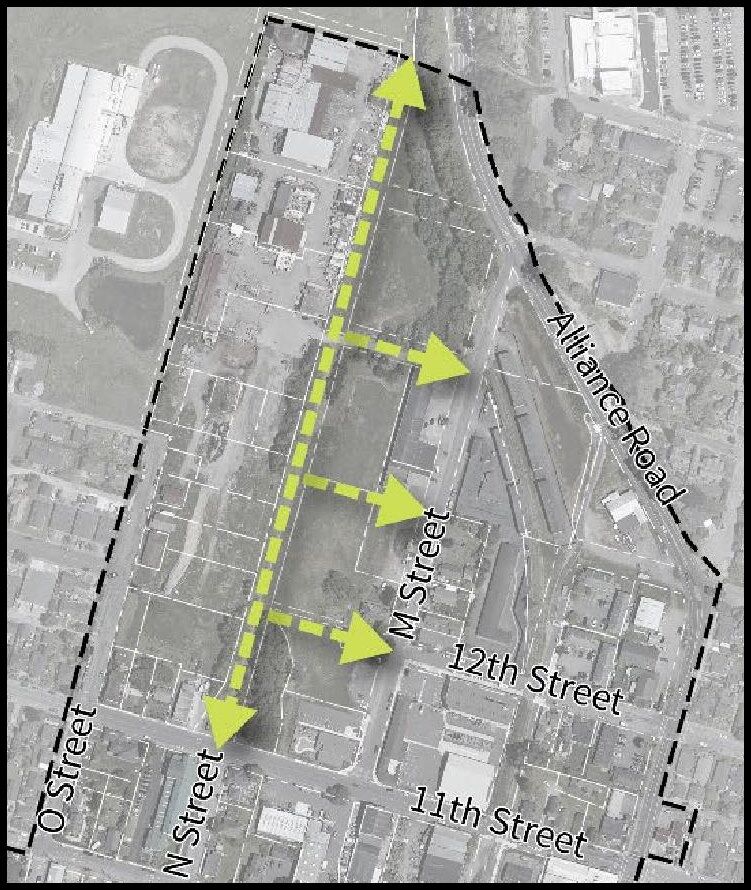
Page 49 Maximum Number of Off-Street Parking Spaces Important
The minimum number of parking spaces for Gateway area buildings has been removed. There is no minimum number of spaces required. There is a maximum number, and those figures are shown in the table below.
In my opinion, having no minimum amount of parking allows the developer to do what that developer wants. If developers think that there is a market for apartments with no parking, then they are welcome to try that. In theory, there’d be a reduction in rent for all of the units in that apartment building of, say $50 a month — as the saved cost of paving and maintaining and providing the land for a parking lot.
But to say that there is a a maximum allowable amount of parking is telling the developers what they have to do in order to build in Arcata. And I propose that they are not going to like this, and they are not going to use the Gateway Code, opting instead to use the State Density Bonus law and then take a waiver on the parking maximum.
The Gateway Area Plan promotes the creation of commercial units in the ground floors of residential buildings. If a storefront or a restaurant has a total maximum number of parking spaces allocated to a, say, 1,000 square foot commercial unit of ONE parking space — is that commercial unit going to have a difficult time attracting a tenant? If you were running a professional business, with six or eight employees plus clients, would you want to rent a space with parking for ONE car?
Here is what is in the Gateway Code:

Page 49 Transportation Demand Management
Added: The TDM Plan must include measures that exceed minimum standards otherwise required by this code.
Page 50 Parking Location and Design
Item F2 was added:
K, L, and N Street access. Site designs for commercial or residential projects that
qualify for ministerial approval may not have primary access for motor vehicles to
parking from K Street, L Street, or N Street if access from an east-west street or from
an alley is possible, with exceptions for emergency access.
Page 52 Bicycle Facilities
Many changes — see the Gateway Code for details.
- Bicycle Parking required. The June 5 draft tied the number of bike spaces to the number of parking spaces, based on Land Use Code in the Arcata. Clearly that was not is wanted for the Gateway area. With a very small number of parking spaces required, we don’t want to have a correlation be number of car spaces and number of bike spaces.
- There is an expanded distinction and definitions of short-term and long-term bike parking.
- There is nothing in the new code regarding charging stations for electric bikes.
Page 54-60 Open Space
- “The Barrel District Master Plan must include a community square….” The phrase “community square” is found 12 times in this Open Space section. There was a request to have this future designate public open space be called by something other than a “square” — since it may not be a square. Indeed, the image shown in “Figure 2-59: Community Square” is not that of a square.
- Barrel District Master Plan, b: “The minimum size of the Barrel District community square is 1.0 acres.” The June 5 draft showed this as 0.50 acres.
- c. The community square design in the Master Plan must include the following:
Removed: Street frontage on at least two sides.
Added: Limit motorized vehicle traffic to no more than two sides of the square. - Linear Parks
No changes shown from the June 5 draft. - Privately Owned Publicly Accessible Open Space
No changes shown from the June 5 draft.For a further discussion on how this open space program might or might not work, see The Myth of “Privately-Owned Publicly-Accessible” Open Spaces on Arcata1.com
 Item 3 Minimum directions — requires a small change.
Currently: Open space shall have a minimum average dimension of 30 ft. in two opposing directions.
Rephrase to: Open space shall have a minimum average dimension of 30 ft. in two perpendicular directions.
Or other wording. The dimensions of a line taken from two opposing directions is the same distance. - Passive Open Space.
No changes shown from the June 5 draft.
Page 60-61 Community Benefits
No changes shown from the June 5 draft.
Appendix II
For Planning Commission agendas, dating from January 1, 2021, through April 9, 2024.
In addition, there were these joint study sessions with the City Council:
- Tuesday, August 23, 2022 – Gateway Area Districts / Building Heights
- Tuesday, August 22, 2023 – K and L Street couplet and inclusionary zoning
- Tuesday, September 26, 2023 – Building height/massing/density, community benefits, and inclusionary zoning
- Tuesday, October 24, 2023
- Tuesday, November 28, 2023
3/12/2024 Planning Commission
B. General Plan and Gateway Code Environmental Impact Report Public Comment Hearing
A public comment hearing on the draft EIR — Not a discussion on the Gateway Code
8/8/2023 Planning Commission
A. Consider a Recommendation to the City Council on the General Plan Updates The Planning Commission made a recommendation to the City Council regarding the General Plan and Gateway Code at its July 11, 2023, meeting. At that time, the Commission recognized the need for ongoing review of the Gateway Code, as well as potential targeted refinement of its recommendation on the General Plan Elements. This item provides the opportunity for Commissioners to provide additional recommendations to the City Council in this more narrow review.
RECOMMENDATION: Staff recommends the Planning Commission continue its review of the Gateway Code and the Gateway Area Plan and General Plan Other Considerations table and provide direction to staff and a recommendation to the City Council. As time allows, the Commission should consider the General Plan topics held over from previous meetings in the “Bike Rack”. The Commission may also consider any other General Plan topic.
7/25/2023 Planning Commission
- Consider a Recommendation to the City Council on the General Plan Updates The Planning Commission made a recommendation to the City Council regarding the General Plan and Gateway Code at its July 11, 2023, meeting. At that time, the Commission recognized the need for ongoing review of the Gateway Code, as well as potential targeted refinement of its recommendation on the General Plan Elements. This item provides the opportunity for Commissioners to provide additional recommendations to the City Council in this more narrow review.
RECOMMENDATION: Staff recommends the Planning Commission continue its review of the Gateway Code and the Gateway Area Plan and General Plan Other Considerations table and provide direction to staff and a recommendation to the City Council. As time allows, the Commission should consider the General Plan topics held over from previous meetings in the “Bike Rack”. The Commission may also consider any other General Plan topic.
7/11/2023 Planning Commission
- Consider a Recommendation to the City Council on the General Plan Updates
The Gateway Area Plan (Plan) will be a new Element in the General Plan that addresses policy specifically for the approximate 138 acres in the plan area. The Gateway zoning ordinance, or Gateway Code, uses a Form-Based Code approach to growth and development in the Plan area. Form-Based Codes emphasize the design and massing of buildings, their interaction with the streetscape and deemphasize land uses. The draft Gateway Code implements the vision of the Gateway Area Plan. The Commission will consider the Gateway Code and make a recommendation to the City Council regarding its amendment and adoption.
The Planning Commission may adopt the following motion or as amended:
• The Planning Commission recommends the policy in the Draft General Plan 2045 dated June 27, 2023, including the Gateway Area Plan, and the Gateway Code dated July 11, 2023, as amended. This is the Commission’s working version for City Council review and consideration.
- The Commission will continue to undertake more specific and detailed review of the Gateway Code, and is able at this time to provide policy guidance on key focus areas as noted in the July 11 adopted Discussion Guide and “Other Considerations” table.
- The Commission will provide a formal recommendation on the final draft versions of the General Plan 2045 and the Gateway Code, along with the Program Environmental Impact Report, that incorporates all further revision and editorial and organizational refinement in early 2024.
6/27/2023 Planning Commission
- Consider a Recommendation to the City Council on the General Plan Updates
The Gateway Area Plan (Plan) will be a new Element in the General Plan that addresses policy specifically for the approximate 138 acres in the plan area. The Gateway zoning ordinance, or Gateway Code, uses a Form-Based Code approach to growth and development in the Plan area. Form-Based Codes emphasize the design and massing of buildings, their interaction with the streetscape and deemphasize land uses. The draft Gateway Code implements the vision of the Gateway Area Plan. The Commission will consider the Gateway Code and make a recommendation to the City Council regarding its amendment and adoption.
6/13/2023 Planning Commission
- Consider a Recommendation to the City Council on the General Plan Updates The Gateway Area Plan (Plan) will be a new Element in the General Plan that addresses policy specifically for the approximate 138 acres in the plan area. The Gateway zoning ordinance, or Gateway Code, uses a Form-Based Code approach to growth and development in the Plan area. Form-Based Codes emphasize the design and massing of buildings, their interaction with the streetscape and deemphasize land uses. The draft Gateway Code implements the vision of the Gateway Area Plan. The Commission will consider the Gateway Code and make a recommendation to the City Council regarding its amendment and adoption.
5/23/2023 Planning Commission – (Gateway Code not actually discussed)
- Consider a Recommendation to the City Council on the General Plan Updates
This meeting will focus on reviewing the Design and Health Elements, as well as the impacts on the Creamery District, Creamery Building, and businesses in the Gateway Area. These topics were included in the “Concerns and Solutions” list finalized by the PC on November 8, 2022. The Commission will use the April 27, 2023, amended Framework (Attachment A) to make changes to the draft Elements. As time allows, the Commission will return to policy recommendations held over from previous meetings, beginning with the Land Use designations map and other Land Use Element policies.
RECOMMENDATION: Staff recommends the Planning Commission use its updated meeting framework to provide a recommendation on the General Plan Updates, including the Gateway Area Plan, and the Form-Based Code for the Gateway Area by July [2023]. Staff recommends the Commission use the framework to discuss amendments to the Design Element, the new Health Element, and topics included in the Gateway Area Plan Concerns and Solutions list. As time allows, the Commission should return to the Land Use Element “Bike Rack” items, beginning with the Land Use designation map.
5/9/2023 Planning Commission
(Gateway Code not actually discussed)
4/25/2023 Planning Commission
(Gateway Code not actually discussed)
4/22/2023 Planning Commission
- Consider a Recommendation on the General Plan Updates and the Gateway Area Plan Form-Based Code
This meeting will focus on the Form-Based Code permitting process and the Community Benefits Program that allows for streamlined permit review in the Gateway Code, as well as the Land Use Element Bike Rack. The first part of the meeting will result in a recommendation from the Planning Commission regarding options for permitting to be included in the Draft Form-Based Code. The latter portion of the meeting will be used to clear items from the Land Use Element Bike Rack using the Framework to make decisions.
3/27/2023 Planning Commission
- Consider a Recommendation to the City Council on the General Plan Updates
At the March 1, 2023, meeting, the City Council received an update on the Form-Based Code (Code) engagement, as well as the engagement process for the overall General Plan planning effort. At that meeting, they directed staff to stop the remaining planned Code engagements; to prepare a draft of the Code for public review as soon as possible; and to receive a Commission recommendation on the General Plan and Code amendments in July of 2023.
February 11, 2023 Study Session
CONSIDER GATEWAY FORM-BASED CODE STANDARDS
- Work Session Framework
- Planning Commission Work Session Memo v3
- Building Placement and Massing Standards (Revised)
- Building Facade & Roof Design and Lookbook
- Building and Roof Design Standards v2
- Building Design Virtual Workshop Summary
- August 16, 2022 Survey
- Survey Responses 01-29-23
- Emeryville Bird Safe Ordinance
August 23, 2022 Joint Study Session with the City Council
III. REVIEW GATEWAY AREA PLANNING
- Background and Context
- Gateway Area Districts/Building Heights
- Transportation Circulation: L Street Couplet
- Next Steps: Public Engagement, Form-Based Code, Amenities
4/12/2022 Planning Commission
1.Review the Gateway Plan Proposed Process and Outcomes
The City has been working on the planning process culminating in the Gateway Area Plan and General Plan update for approximately five years. With any community conversation with such a duration, there is a need to revisit prior decisions to understand the context for the current work. This item will review the history behind the decisions related to the idea of an area plan, using a form-based code, and the purpose and benefits of a community design process.
RECOMMENDATION: Staff Recommends the Planning Commission receive a presentation on area plans, form-based codes, and the purpose of community design and provide recommendations to staff and the City Council.