Estimated reading time: 10 minutes
The following articles are reprinted from the Mad River Union, from July 13 and August 10, 2023, as part of the interview series by Dana Utman on environmental issues. The original articles can be found here and here on the Mad River Union website. Please support our local newspaper! The Mad River Union contains information found nowhere else. Subscriptions only $30 a year if you get three years.
Environmental Planner Aldaron Laird: Local sea level rise consequences are going to be ‘mind boggling’
by Dana Utman

Here on planet Earth our present climate change conditions include increased greenhouse gas concentrations. In combination with subsidence (sinking land) and other oceanic forces such as storm surges, projected mean sea level rise will affect the coastal zone. This will increase coastal vulnerability such as erosion rates and shoreline retreat among other potential impacts. These are expected to have numerous negative social consequences.
“We are actively working on this constantly,” Larry Oetker, executive director of the Humboldt Bay Harbor, Recreation and Conservation District stated on September 13, 2022, regarding sea level rise.
Aldaron Laird is perhaps the most knowledgeable and well-known sea-level rise expert in Humboldt County. He is an environmental planning consultant who has specialized in sea level rise vulnerability assessments and adaptation planning for Humboldt Bay.
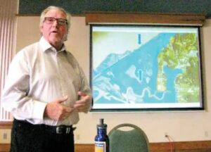
I spoke with him recently and asked him questions regarding the impact locally. He has been presenting a special interest class on sea level rise with local historian Jerry Rohde (which I have participated in) through a Cal Poly Humboldt OLLI class. This is part one of our interview.
Dana Utman: Why did you and Jerry (Rohde) decide to collaborate on sea level rise?
Aldaron Laird: I got together with Jerry because I wanted to do a class on sea level rise on Humboldt Bay. So we started doing an OLLI class where we looked at past, present and future.
Jerry would do the first part of the class and talk about the American invasion (around 1850) and how it changed the bay by diking, building the jetties at the entrance of the harbor and other things that changed the historic or the natural aspect of the bay. Then, I would describe the bay in its present-day terms.
Jerry is a real strong community advocate. He was really active in trying to stop herbicide spraying. He does a lot of classes on different aspects of the historical books that he’s been researching and producing. I think he’s produced five historical books and he’s trying to produce two more. He saw climate change and sea level rise as an urgent community issue and so we’ve been collaborating.
I had done a contract that actually was the first sea level rise project on the bay, based on the historical atlas that I produced. I researched all the original maps going back to 1806 all the way up to present day with aerial photography. I digitized the shoreline of Humboldt Bay to show how it changed over time, either naturally or artificially and added the historical context to it.
You have to have present-day shoreline to see what it’s made of, how much of it is natural, how much of it is artificial, what the elevation of the shoreline is with a sea level rise vulnerability assessment.
The second part of the class would be the present day. This is the way it’s laid out, here are the six hydrologic units (Mad River Slough, Arcata Bay, Eureka Slough, Eureka Bay, Elk River Slough, and South Bay), here’s all the infrastructure, and how many miles are eroding. The last part of the class would be the sea level rise. We have the highest rate of sea level rise on the West Coast.
Dana Utman: On a scale of 1 to 10, how important is the issue of sea level rise in this area, and describe some of the changes we will see.
Aldaron Laird: I would say it’s a 10. The significance of the change that we’re going to see over the next 40 years is going to be mind boggling.
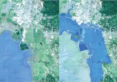
Most people just think this is the way it’s always going to be. In 1890 it was entirely different. Old Arcata was on the edge of the bay. When sea level rise reclaims 7,000 to 10,000 acres of former tidelands, it’s going to be shocking to people.
We’re going to lose communities like King Salmon and Fields Landing and possibly most of Fairhaven areas South of Samoa and Arcata and there are areas over in Eureka. A lot of people are just going to wonder what the heck happened.
Sea level rise will initiate bluff retreat like in Big Lagoon (where it has affected property development). It’s going to flood Highway 101. If you live in Arcata 100 feet in elevation you’re not going to be affected by sea level rise.
But if it takes out the wastewater treatment plant you will be. And if it takes out PG&E’s electrical transmission system or their natural gas lines, it’s going to affect everybody on Humboldt Bay.
The water will go all the way up to about Old Arcata Road and Samoa Boulevard past the old waste transfer stations. You won’t be able to drive to Manila because the area will be underwater and salt marsh.
The only way to get to Manila will be through Eureka over the bridges. The lower Elk River Valley area will be underwater. You won’t be able to drive up Elk River because there won’t be a road. Thompkins Hill off ramp all the way to Table Bluff would be underwater.
Unless they raise the seawall the sea level rise could very easily erode 115 feet of bluff right back to the nuclear fuel dry-cast storage and (worst case scenario) they could topple into the bay.
[Note: According to the U.S. Nuclear Regulatory Commission, on July 16, 1985, the Humboldt Bay Power Plant status was changed to possess-but-not-operate after it initially was shut down for annual refueling and seismic modification and then found that restarting it would not be cost effective.]
By the year 2100 the projection that you use for critical infrastructure will be about two meters (6.7 feet). Our average King Tide is about 9 feet, so the water will get up to about the 16-foot contour elevation. When we go to the year 2120, that’s when we get the third meter of sea level rise.
All of a sudden it starts flooding the chunk of the urban area in the lower part of Arcata and almost all the Gateway Plan area will be underwater. Everything west of Broadway in Eureka will be underwater.
Dana Utman: Explain why Humboldt Bay has a greater sea level rise than the rest of the California coast.
Aldaron Laird: The ocean’s not doing anything different off of our coasts than in Crescent City or San Francisco.
What is different though is we’re at the tail end of the Cascadia subduction zone. Multiple tectonic plates – the Gorda, Cape Mendocino and North American (also known as the Mendocino Triple Junction) and the Pacific are all grinding together.
The Gorda Plate (and the Juan de Fuca) is diving underneath the North American Plate right off our coast in Humboldt County. As they plunge underneath the North American Plate they’re bending the edge and pulling it down.
So the tectonic subsidence is probably more than half of our sea level rise, and that’s why we have the highest rate of sea level rise on the West Coast. In Crescent City, the Pacific Ocean and the North American Plate are bulldozed together and they’re actually pushing the ground up. There is positive ground elevation.
The state agencies have gotten really serious about (sea level rise) now, like the Coastal Commission, the Coastal Conservancy, the Ocean Protection Council, and the State Lands Commission. Caltrans has too. They’ve inventoried all of their roadways and they’ve assigned a priority rating of one to four for all the segments that are vulnerable to sea level rise. As you can imagine, Highway 101 is high priority number one.
 I don’t think local government is taking it seriously and looking far enough ahead. I think local government moves really slow. You would think that Arcata would know where they’re going to build a new wastewater treatment plant and keep this one protected for as long as possible, but start building the new one. If they found a new location for a wastewater treatment plant they sure aren’t telling anybody about it.
Everything shuts down the minute that plant does. Within an hour we can’t flush toilets, and so that means you can’t run water. That’s a pretty significant impact. I mean even considering building and expanding the city into the Gateway Area or any area south of Samoa Boulevard or west of Old Arcata Road – why would you make an investment in an area that’s going to be inundated on former salt marsh?
The city of Eureka has a lot more exposed waterfront than Arcata. They don’t provide water and sewer services to King Salmon and Fields Landing. The Humboldt Community Services District does, but the services district doesn’t control land use and zoning, the county does. There’s a real disconnect about who’s going to take care of King Salmon and Fields Landing.
I don’t think the Coastal Commission is taking it seriously either, even though they’re funding the cities and the counties to update their local coastal program to address coastal flood hazards. The Coastal Commission knows more than anyone that 80 percent of the area that’s vulnerable to sea level rise this century is in their jurisdiction. So even if Arcata updates its local coastal program, 80 percent of the area that’s vulnerable they don’t actually control.
The Coastal Commission doesn’t want to do planning. They want to offer sea level rise guidance and come up with sea level rise policies, but those are just guidance policies that the cities don’t have to follow.
Dana Utman: What do you think residents living here along the Humboldt Bay should be doing to help mitigate sea level rise right now?
Aldaron Laird: If you live at an address that will get flooded, and have the money, rebuild (your home) so that the ground floor is essentially on pilings and the livable house is up above 10 feet high. That’s what the Coastal Commission requires them to do in King Salmon. The ground floor has to be designed so that it could be flooded and washed out without affecting the house. The livable house is up above. But what if you can’t drive to your house because the streets are underwater, or if you don’t have a sewer anymore because all the salt water is intruding into the sewer lines?
People can go to the local decision makers and pressure Caltrans. I keep thinking, what’s going to make people pressure the city councils or the Humboldt Board of Supervisors to do something? It’ll be when the banks won’t write a mortgage because the insurance underwriters won’t insure it. That’s when those property owners are going to demand that they do something.
They’re putting all this money and energy into the corridor between Eureka and Arcata and they’re doing absolutely nothing for South Bay. They’re not even monitoring it because they don’t have a project there. It’s the same way with PG&E. When is somebody going to ask them what their sea level rise adaptation strategy is for Humboldt Bay and how are they going to protect the new power plant? It will be underwater before the end of the century. They’ll have to move it. Do they have a plan? Are they beginning to at least think about it? Aldaron Laird is producing two photography books – one on Humboldt Bay and one on our coastal lagoons – which the University Press is going to publish.
Note: Dealing with climate change can be depressing. So how can we adapt and stay mentally healthy? Joshua Gordon, director, National Institute of Mental Health (NIMH), has said that understanding the impact of the environment on mental health has long been part of psychiatry and psychology efforts to develop interventions for mental health conditions.
The next two articles will address this through conversations with different practitioners.
“All things share the same breath – the beast, the tree, the man. The air shares its spirit with all the life it supports.” – Chief Seattle


 They sold the land at a huge profit. It was an agricultural boom. They raised potatoes and other kinds of crops and shipped them to San Francisco. The dikes are still there. In many instances the dikes aren’t any higher than what they built in 1890. They were high enough so that the average king tide in 1890 wouldn’t overtop them and have all that saltwater kill all of their plants.