

To the City Council and the Planning Commissioners:
Solar shading, building massing, and the “feel” on the street are easily and quickly seen in a 3D image. Without the 3D image, every design aspect becomes theoretical. With 3D images, the proposed buildings become more real.
With the Form-Based Code here, and with the City Council and the Planning Commission in discussion about the look and feel of future buildings in Arcata —
Getting more 3D images of buildings and streets is of utmost importance.
The budgeted amount for 3D GIS modeling is $34,596. As of June, 2023, for development of 3D modeling: Over $34,400 has been spent. There is under $188 that remains.
For that $34,400, what have we seen of this?
Not very much.
In the Arcata draft Gateway Area Plan, we’re using “Form-Based Code” as a backbone of the Plan’s design. Form-Based Code uses illustrations and architectural diagrams to show — clearly, we hope — the intentions of the code. And to show to both the developers and the public what the City planners want new buildings to look like.
With the Form-Based Code here, and with the City Council and the Planning Commission in discussion about the look and feel of future buildings in Arcata — getting more 3D images of buildings and streets is of utmost importance.
Getting these illustrations right is crucial. For a discussion (with illustrations) on why 3-D modeling is so important, see What is 3D Modeling and why is it so crucial.
What 3D tools do we have?
The planners have the software — and they are capable of making valid 3D images.
To repeat: The planners have the tools. The Community Development Department just isn’t providing the 3D images for us.
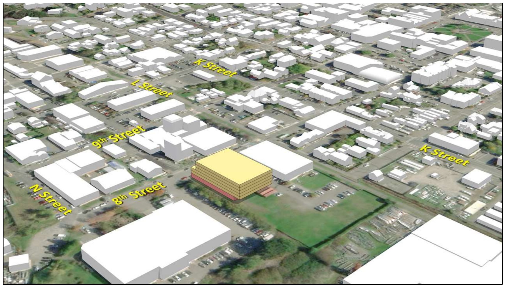
The image below was made prior to December, 2021. It’s on Page 23 of the December 2021 draft plan, page 24 of the July 11, 2023 draft. We know the plan’s consultant is capable of making 3D drawings.
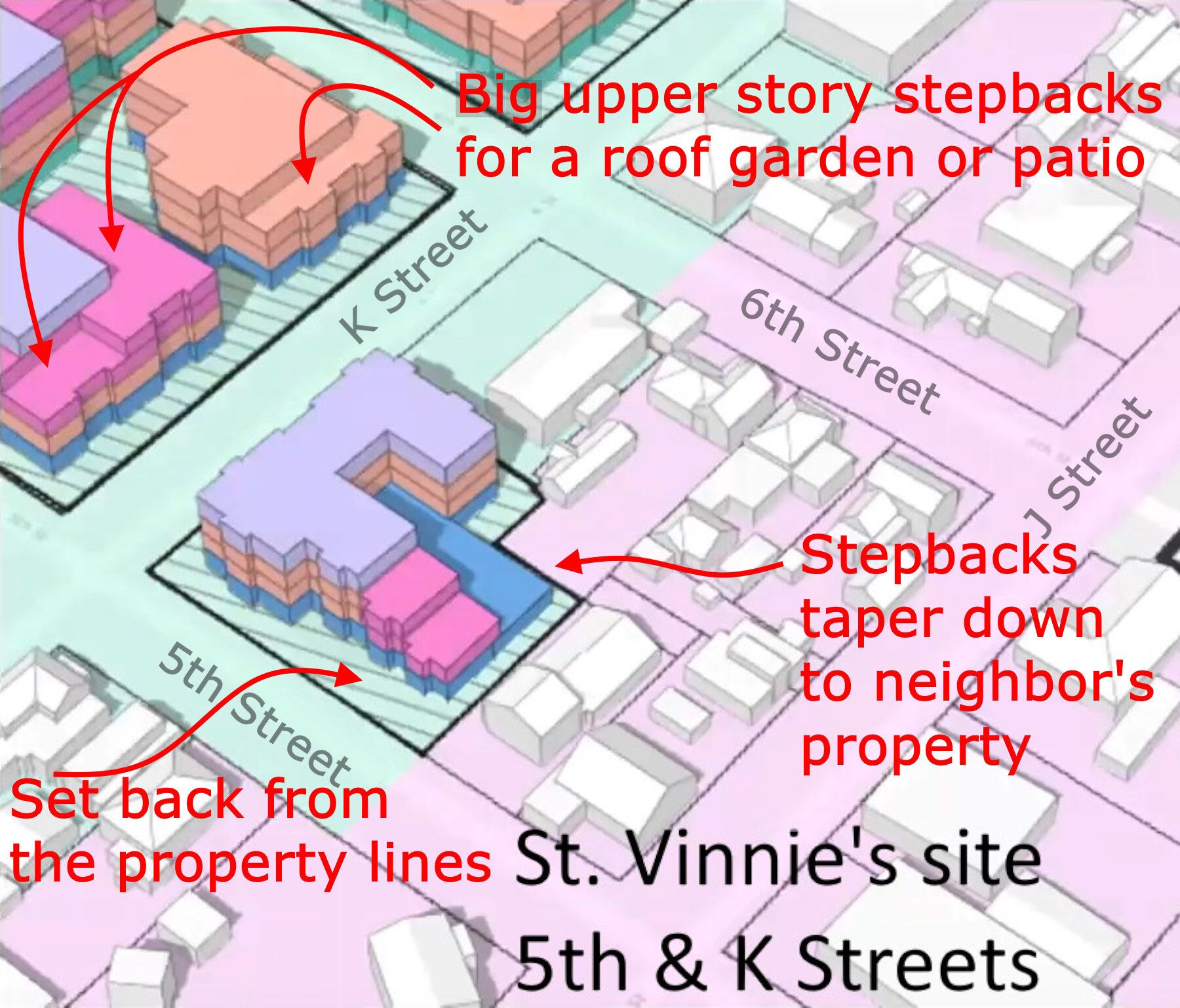
Here’s an image grabbed from a “Building and Massing” video. I added the text and arrows. We can note the deep upper-floor step-backs, how the buildings are set back from the property lines, and the smooth tapering of building height where the building looks over the neighboring property. As of August 2023, none of that has survived the Planning Commission process. See: Will upper floor step-backs vanish from the Gateway Code?
Here’s a nice overview showing the sites along K Street. There’s also some development way at the far western edge of the Gateway area, along Q Street past the current Schmidbauer building, and another building at 10th & O.
The parcels along K Street include the Bud’s mini-storage parcel, the AmeriGas parcel, the St. Vinnie’s parcel, and the car wash parcel. 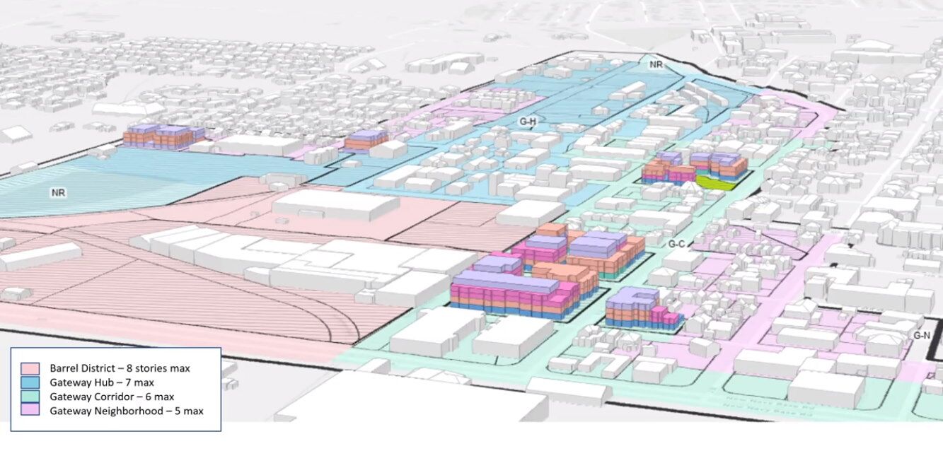
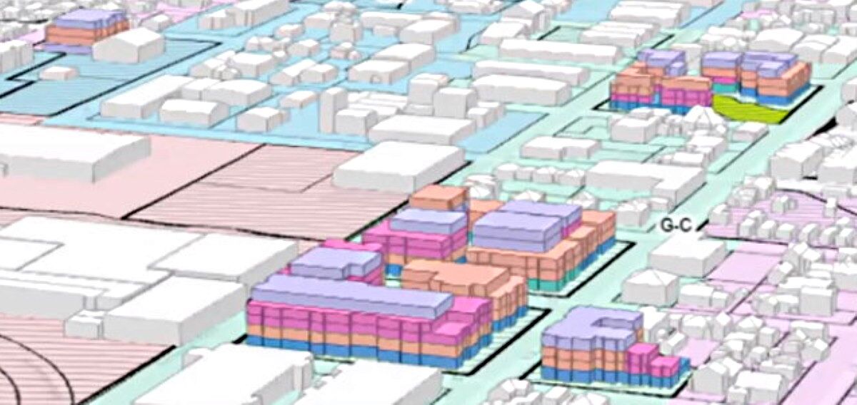
Below is a closeup. Please note:
- The northern side of the AmeriGas site is showing a building height of 3 stories. The building to the west of that is 5 stories — and it is set back over 80 feet (as it looks) from the street. (It looks to be a separate building — it is is a single building then there’d be a very deep step-back of about 80 feet.) This gives some degree of southern light and sun to the 1-story historic Devlin cottages that are just to the north.
- The image shows buildings of 5-story heights right along the L Street corridor — right across from the current industrial buildings where Wing Inflatables is housed. If we would want to have the L Street Corridor be a full-width mostly car-free linear park, the walkers there would have a few 5-story buildings dominating their view of the Eastern and Southeastern light and sky. Not good for the walkers.
This is what can be easily and quickly seen in a 3D image. Without the 3D image, every design aspect becomes theoretical. With 3D images, the proposed buildings become more real.
What the draft plan promised
![]() A blank page entitled “Visualizations” has been in the December 2021 draft, the October 2022 draft, and now again in the July 11, 2023 draft. It apparently is not important to the authors of the draft Gateway Plan to provide Visualizations. (In the image below, the original is a full blank page. This has been edited only to take up less room,
A blank page entitled “Visualizations” has been in the December 2021 draft, the October 2022 draft, and now again in the July 11, 2023 draft. It apparently is not important to the authors of the draft Gateway Plan to provide Visualizations. (In the image below, the original is a full blank page. This has been edited only to take up less room,
It says:
Following public feedback regarding draft Gateway Area Plan, several pages will be added here to display visualizations of selected opportunity sites and other desirable building types within the Plan Area.
What we’ve seen so far
After months of promises and excuses, the 3D modeling came out, finally, in early August, 2022. We saw a very small amount of 3D imaging from David Loya, with some 3D modeling shown in some “Building and Massing” video presentations that he did. But other than that, and since that time — nothing.
And here we are, one year after that, over a year and a half from the first Gateway Area Plan draft, and still no 3D modeling. The placeholder page in the draft marked “Visualizations” is still blank.
- The rendering of the design by Julian Berg appears in the first “Building and Massing” video presentation for about 1 minute, as black & white. It appears in color for 2 seconds.
If it were not reproduced here on Arcata1.com, it would be lost. - The 3D images of the St. Vinnie’s site and other possible buildings are shown for under a minute in the 3rd Building & Massing Video. Those images are shown in Will upper floor step-backs vanish from the Gateway Code? and other locations on Arcata1.com.
And that is about it for 3D Modeling from Arcata’s Community Development Department — after almost $35,000 spent.