

Estimated reading time: 14 minutes
This article was first published in September, 2023. Some figures updated, April 2024
Jump to: Won’t higher fees and more costs to the developer make it more expensive to build — and therefore result in higher rents?
Jump to: Solutions here.
Note: In December, 2023, the Community Benefits program was completely revised. The range of points offered is now 0 to 3. (It had been 0 to 9.) After reading this article, you may wish to read or skim through What’s in the Community Benefits Program for the Gateway Area Plan? written in March, 2024.
This article requires revision. However, the concepts here remain valid. It is not economically advantageous for a developer to create Privately-Owned Publicly-Accessible parks and open space.
The Community Benefits Program in the Gateway Area Plan is a noble concept.
Unfortunately, in its current conception, it will not work.
That is to say: In the sense of providing the results that are desired for the Gateway Plan, the Community Benefits Program will not work as intended. This article is one of a series of articles that explores some of the fallacies Community Benefits Program.
The “Privately-Owned Publicly-Accessible” Open Space program is another ill-conceived aspect of the Gateway Plan. Again, noble in concept — and unlikely to give desired results in its execution. In my opinion, there is no way that a private developer is going to make a publicly accessed space that the building owner has to insure, maintain, landscape, keep clean, and keep safe.
Let’s look at the design of the Privately-Owned Publicly-Accessible Open Space program, and see how it can be improved.
What is the “Privately-Owned Publicly-Accessible” Open Space program?
As stated in the Gateway Form-Based Code document:
“Definition. Privately owned publicly accessible open spaces are courtyards, plazas,
paseos, and other similar spaces open to the public and provided as part of new
development on property that remains under private ownership.”
Under the Privately-Owned Publicly-Accessible Open Space program, the land-owner / developer must give up a portion of the land and convert it, at the developer’s expense, to a publicly-accessible open space — a park or parklet, a small plaza, an eating or meeting area, or similar. The owner is responsible in perpetuity for the cleaning, maintenance, and (in theory) safety of this space.
In one large section of the Gateway area, this privately-owned publicly-accessible open space program is mandatory — or the developer can pay an in-lieu parkland fee. (See below for the fee amounts, and issues with the in-lieu fee program.)
In other areas, there is no mandatory requirement. The developer can get community benefit points for providing privately-owned publicly-accessible open space. A developer is extremely unlikely to pursue community benefit points in this manner. See below for details.
Where is it mandatory, and where is it optional?
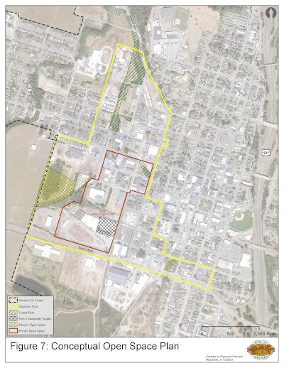
To the right is Figure 7, “Conceptual Open Space Plan,” from Page 62 of the July 11, 2023, v12a.2 draft plan. [Page 60 of the December 12, 2023, v14a121223 draft.]
The yellow line is the outline of the Gateway area.
The dark red line is the outline of the “Private Open Space” area. Development within this area is required to provide privately-owned publicly-accessible open space or pay the in-lieu parkland fee.
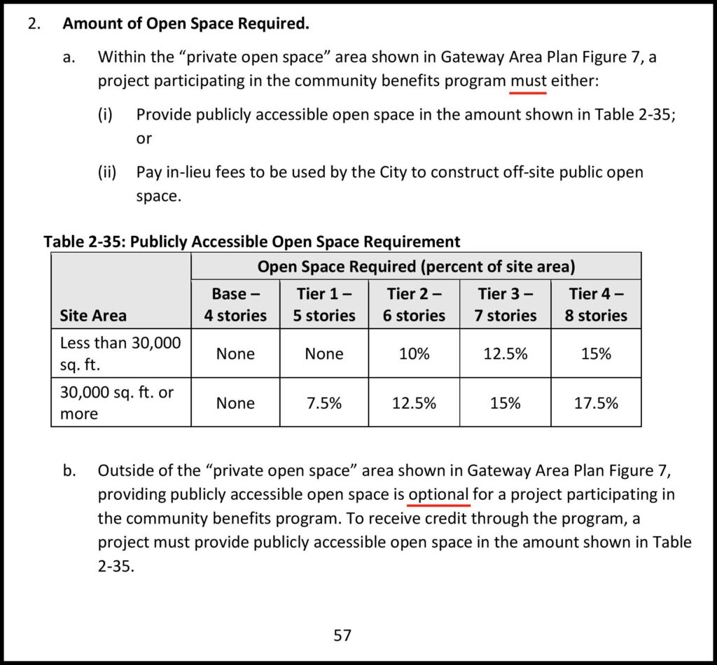
From the Gateway Code document, Version 2. Note: “Tier 4” of 8 stories is no longer an option. (The document is not dated. The PDF is from September 22, 2023.)
Here is Figure 7, enlarged and modified to show detail. The dark red line showing the boundaries of the Private Open Space has had its color changed to bright blue, for clarity. This is the area where the developer must provide open space or pay in-lieu fees. 
Here is the same image with names of local buildings, so you can place the current boundaries of the “Privately-Owned Publicly-Accessible” Open Space program.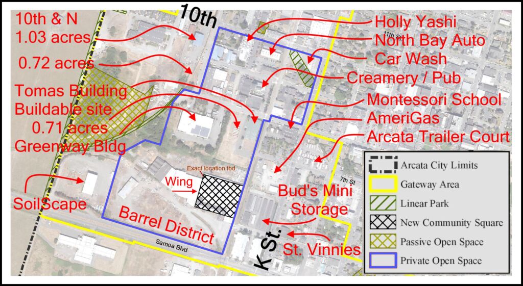
The current boundaries for mandatory participation in the “Privately-Owned Publicly-Accessible” Open Space program are arbitrary. The boundaries do not provide the best benefit for people, and do not represent good planning.
- K Street from Samoa Boulevard to 11th Street is viewed as a pretty barren area. Wouldn’t it be good to have some public access spaces along K Street?
- The L Street corridor has now been designated as a full-width linear park, with approximately four blocks of a pedestrian-oriented woonerf. (This was determined at the first Gateway joint PC/CC study session, August 22, 2023.) Wouldn’t it be good to have some public access space alongside the linear park, as paseos or “parklets” or eating and meeting spots for future restaurants and shops?
- Certain large parcels are located just outside of the current Private Open Space boundary line. Why aren’t these large parcels within the boundary?
The two parcels at the western edge of the Creamery District, at N Street around 9th and 10th, seem like natural locations for a parklet.
The Clothing Dock / German Motors building at 11th & K is outside of the Private Open Space zone, as is the Ag Sales building parcel. Why? The strip along 11th Street from K to N could use a big make-over in terms of its lack of pedestrian friendliness. Why not require some expansion of public accessible space along 11th Street? That 11th & K corner is a fantastic spot for people to come to sit and meet — and eat and shop.
Here’s what an expansion of the Private Open Space zone might look like. Possible expansion boundaries are the bright green dotted line. These expanded boundaries add: West of the Creamery, the western portion of the Barrel District, along K Street, and along the L Street Linear Park. 
How much private land is the developer required to provide as publicly accessed space?
Based on the table in the Gateway Form-Based Code, the open space requirement is based the proposed building height and whether the site is larger or smaller than 30,000 square feet. As a means of understanding the size of such a site, the site for Sorrel Place, on 7th Street between I & J, is just under 30,000 square feet. An Arcata city block is 62,500 sq.ft., or 1.42 acres.
So for a proposed 6-story building on a site larger than 30,000 square feet, the developer would need to provide 12.5% of the site area as privately-owned publicly-accessible open space. If the site was the 0.71 acre site, like the one to the west of the Tomas Building, that would be 3,850 square feet — a square that’s 62 ft. on a side or a rectangle 50 x 78 feet. And, as mentioned, the developer would need to create this space, clean it, and maintain it, for the life of the building.
For a proposed 7-story building in the Barrel District, it’s a bit different. A 7-story building requires 15% as privately-owned publicly-accessible open space. A parcel where the lumber mill log deck now exists is 3.08 acres, or 147,000 square feet. That results in a public space of about 22,000 sq.ft., or a little over half an acre. That’s a square about 150 feet on a side, or a rectangle that’s a block long (250′) and 88 feet deep.
The Wing Inflatables site is 8.37 acres, or over 364,000 square feet. The 15% requirement for that site works out to 1.25 acres of privately-owned publicly-accessible open space, permanently maintained by the developer.
| Site Size | Sq.Ft. | Building Height | Required privately owned open space | |
| 0.71 acres | 30,800 | 6 stories | 3,850 sq.ft. | < 0.10 acre |
| 3.38 acres | 147,000 | 7 stories | 22,060 sq.ft. | 0.51 acre |
| 8.37 acres | 364,000 | 7 stories | 54,670 sq.ft. | 1.25 acres |
For a site within the Private Open Space boundary: How do the in-lieu fees work?
As an alternative to providing a mandatory privately-owned publicly-accessible open space, a developer can opt to pay in-lieu fees. There are two fairly major issues with this system.
According to the City of Arcata master fee schedule, the amount of the in-lieu fee is equal to the fair market value of the amount of land which would otherwise be required to be dedicated to the open space, plus 20%.
The Community Benefits program point chart shows: “Pay park fee in addition to the park in lieu or recreation fee for new construction equal to 1.5% of total project construction
costs.” And if that is done, the developer receives 3 community benefit points 1 community benefit point. [Point system updated in December 2023]
Is this an optional fee of 1.5% — or a mandatory fee? From the wording, it is not clear. It seems to read as an option, if the developer wants it. Regardless, it is a highly expensive way of getting only 3 points. More on the point system, below.
Let’s use as an example the 0.71 acre parcel. That is half of an Arcata city block in size.
For this exercise, let’s say that the market value of this parcel is $500,000. An in-lieu fee of 12.5% would result in a $62,500 base fee. With the added 20% that totals $75,000 — based on property value.
The Gateway area has in-lieu fees based on construction costs. Let’s use, say, $15 million as construction costs. Note that land costs, overhead, interest, and other “soft” costs are not included. Calculating 1.5% of $15 million would be $225,000.
So the options for a developer of that site would be:
-
- Build a public space.
• Eliminate 12.5% of the site from the total area used for a new building.
• Design a new building and parking, pathways, entrance, etc. on 87.5% of the existing parcel.
• Design a 3,850 public space, with brick or concrete walking surface, planter boxes, landscaping, outdoor seating, trash cans, and so forth.
• Have that public space built, and pay for the cost of that.
• Provide cleaning, maintenance and upkeep, landscaping for this public space — in perpetuity. For the life of the building.
• Insure it and have the liability of legal responsibility for activities that take place on this site, as it is still under legal ownership of the owner of the entire property.— OR —-
- Pay $225,000 to the City as in-lieu fees. That’s it. Pay it once and be done.
- Build a public space.
Will a developer choose to create the public space … or pay the in-lieu fee?
Which makes sense, financially? Which would you do?
Paying $225,000 as a one-time fee is a whole lot less money and loss than losing 12.5% of your land, paying to create a parklet, and then being responsible for its care, maintenance, clean-up, and insurance — forever. A whole lot less.
Will the in-lieu fees that are collected be designated for use in the parks within the Gateway Area?
No. The in-lieu fees could be used for any City park, even one that may be one or two miles away, and not within easy walking or biking distance, especially for a child. From 11th & K Streets to the Community Center is one mile.
How about of outside of the mandatory Private Open Space zone. Will developers create public spaces in order to gain Community Benefits points?
[Note: As of November/December 2023, an entirely different Community Benefits point system is being discussed. Range of points was 0 to 9 — it is now 0 to 3. The Community Benefits points given for the development of public spaces is now 1 point, for any size park.]
At the current time (September 2023), a developer would get:
0 points for dedicating under 5,000 square feet of land for use as a public open space.
4 points for dedicating 5,000 to 9,999 square feet.
6 points for dedicating 10,000 to 20,000 square feet.
8 points for dedicating more than 20,000 square feet.
5 points (in addition to the above) for improving the open space at a cost of 1.5% or more of the total construction costs. For a $20 million building, that would be spending $300,000. For a $40 million building, such as a 5 or 6 story building, that would be spending $500,000.
In the example above, on the 0.71 acre parcel (that’s half of an Arcata block) that calculates to 3,850 square feet of public open space, if that parcel were outside the mandatory private open space zone, a developer would get ZERO points for making that size of public space. The developer would get 5 points for creating the open space, and spending, say, $500,000 on it.
As an example of a parcel that is not within the current mandatory private open space zone, we can look at the AmeriGas site. The parcel is 1.30 acres; if it were combined with the small PG&E parcel in the northwest corner it would be about 1.42 acres. For a six-story building located somewhere on the full block, it would need 7,800 square feet of public space. For that, the developer would receive the “whopping” amount of just 4 points. Plus another 5 points if 1.5% of the building cost were spent on the park — perhaps if $800,000 were spent on it. That’s a lot of money to spend to just get 5 points.
That developer would have given up 12.5% of that parcel and be required to clean and maintain that public space — forever. For that, only 4 points.
And here’s what’s wrong with the Community Benefits point system
[Note: As of November/December 2023, an entirely different Community Benefits point system is being discussed. The points that are given are now 1, 2, or 3 points, and many items — including all listed here in this example — have been eliminated. The details of the example shown here are not valid. But there are other ways that the developer can “game” the system and avoid providing any open privately-owned open space.]
To put that into perspective, a developer can get 2 points for giving free wi-fi. That might cost a few hundred dollars a month. The developer gets 2 points if 15% of the materials are renewable, i.e. wood. And another 2 points if 5% of the materials come from Humboldt County. And 2 points for a community garden that could be as small as 2 x 5 feet. Provides a profit-making publicly accessible electric charging station — 2 points
The total there is 10 points — and the developer has spent perhaps $10,000. In the scenario involving the privately-owned publicly-accessible open space, the developer has lost one eighth of the building site (12.5%) and spent $800,000 — all to get 9 total points.
The Quimby Act Guidelines
The Quimby Act applies to sub-divisions, and so is not directly applicable to the Gateway Area Plan, as it is not a sub-division. It does give a view of how much open space is considered to be appropriate when planning for in increase in population.
For more information on the Quimby Act guidelines, see Quimby Act Dreams — How do we get parks in Gateway?
The Quimby Act, originally passed in 1975, required new subdivisions to provide open space access in the area of the subdivision — or pay fees so that the city could provide parks in that area, to serve the residents living there.
The guideline was for there to be for 3 acres of accessible parkland (i.e. not wetlands or other non-entry open space) per 1,000 persons.
The Arcata municipal code ups that amount a bit. It states:
9.86.030 Park Land Dedications and Fees
D1. General standard. It is found and determined that the public interest, convenience, health, welfare, and safety require that five acres of property for each 1,000 persons residing within this City be devoted to neighborhood and community park and recreational purposes. (link)
So for the Gateway area the math would be like: A full build-out of 3,500 housing units; ~2.2 person per housing unit = 7700 people or 7.7 thousand; 5 acres per thousand = 38-1/2 acres needed. That’s a lot of open space — that sounds great!
It is a lot of open space because the Gateway plan encourages dense housing development — and there will be a lot of people there. Potentially more people there than the neighborhoods of Vaissades, Westwood, Greenview, and Sunny Brae — combined.
Even if if were only 500 apartments and ~1,000 new people, that would be 5 acres of new open space.
Currently the Planning Commission is proposing 1 acre of public open space — that’s for the new town square to be located in the Barrel District, location (and date when it’s built) to be determined. If the Barrel District is not built in for the next 20 years, then that new town square won’t exist for the next 20 years.
The L Street Corridor Linear Park will be about 3-1/2 acres in total. But that’s a park that already exists, for the people who are there now. The Quimby Act calls for new parks — additional space — for the new people who’ll be coming.
Won’t higher fees and more costs to the developer make it more expensive to build — and therefore result in higher rents?
Our Community Development Director David Loya told us from the beginning that the streamlined approval and Form-Based Code would provide savings of hundreds of thousands of dollars to the developers, in the form of quicker approvals, lower interest costs, greater certainty of getting the project approved, and easier to understand building codes and requirements. He told us that this would enable the developers to give back to the community those hundreds of thousands of dollars that they’d save.
Well, here is their chance to do just that. The community needs parks and playgrounds and gathering places, of all sizes and configurations.
There are many costs involved in constructing an apartment building. You wouldn’t declare “If we have to pay for Worker’s Comp insurance, then we’ll have to have higher rents” or “Why do we have to have a fire-suppression sprinkler system? It will just make the rents higher.” Providing open space for people is a cost of doing business. If this is minimized or disregarded, the quality of life of everyone suffers.
Solutions
- Expand the boundaries of where mandatory privately-owned public-access open space is required. Consider the map of expanded boundaries, as shown above.
- Substantially increase the amount of the in-lieu fees — both as an encouragement for the developers to build public parklets and as a means of collecting higher fees. Suggest to at least double the existing fees. A 3% fee on a $30 million building results in a park in-lieu fee of $900,000.
That amount of a fee is appropriate for a $30 million building that may have 120-150 people living there.
- Designate those fees for Gateway area parks. I will not accept as a rebuttal “It can’t be done — the fees are co-mingled with the entire Arcata park budget.” It can be done.
- Taking fees from Gateway area development and using those fees for better trails is not acceptable. Trails are great — but trails are not parks and playgrounds. Keep reading for more on this.
- Have an honest discussion about the intents and purposes of the Quimby Act — and why the City of Arcata opted to increase the guideline from three acres per 1,000 new residents… to five acres per 1,000 people.
- Look at finding funding to buy property for a city park. Centrally located and large would be ideal. Appropriate locations might be: The parcel to the west of the Tomas Building; the car wash site; the AmeriGas parcel; the parcel west of the Creamery area, west of N Street. And wherever a new park might be considered, adjust the Form-Based Code so that a 4 or 5 or 6 story building cannot be built directly adjacent to that new park, without strong and deep step-backs.
See: Open Space Programs Page 64 in the draft Gateway Area Plan. 7/11/2023 v12.a2Implementation Measure Imp‐GA‐6.2. Public Open Space Acquisition Program. Seek to secure publicly accessible Open Space within the Gateway Area Boundary, both by easement and fee title, with an emphasis on acquiring lands for a publicly accessible open space in the Southwest Plan Area. Identify, develop, and prioritize parkland and Open Space projects that are eligible for Federal and State funds and continue to pursue all available options for funding new and improved parkland facilities.
- Recognize that parklets and playgrounds are good for the community, and good for business.
- Recognize also that there will be 1,000 or 2,000 people living in the Gateway area. In the event of a greater build-out, there could be 5,000 people there.
Trails are wonderful and necessary, and we are all happy to see more and better trails in the Gateway Plan. Places to meet, sit, and talk — that is different from trails.
People of all ages need outdoor spaces to congregate and enjoy life. To take a stroll and meet a friend. To eat lunch outside. For children to play with other children.
There’s much talk about the necessity of building community.
Parks and outdoor meeting spaces: This is how you build community.
Draft Gateway Area Plan
Chapter 2. Community Benefits and Development Standards
Version 7/11/2023 v12a.2
Draft Community Benefits Program – Points
Taken from the agenda packet of the City Council / Planning Commission joint study session, on August 22, 2023