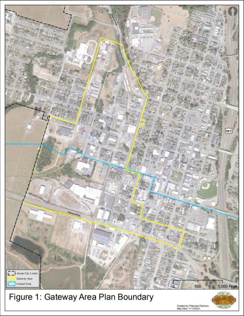
Somewhere between December 2019 and December 2021 — two Covid-impacted years — the Gateway area grew from 87.64 acres to 138 acres. Here is some of that history.
It is possible that the 2019 Housing Element figure of 87.64 acres was a total of all the parcels in the area. If so, it would not include the acreage of the streets and other rights-of-way, which would amount to something around 20 or 25 acres.
December 2019: The Housing Element
In December 2019, the section of the General Plan called “The City of Arcata Housing Element — 6th Cycle 2019-2027” was released [36 pages, link here or on this site here]. In the Appendices to the Housing Element [218 pages, link here or on this site here], there is a description and a map of the Gateway area.
From the Housing Element, page 86:
As shown in Figure A4-2, the Gateway Corridor is a 90-acre site near downtown, generally north of Samoa Boulevard and east of K Street. This area is predominantly zoned Industrial Limited and Industrial General. The proposed development in the corridor will involve the development of a specific plan to create a neighborhood of midrise, mixed-use buildings.
[Emphasis added]
Here is the map from the 2019 Housing Element:

When did the Gateway Plan change from a “Specific Plan” — as outlined in the December 2019 Housing Element — to an “Area Plan”?
That is a long story, and may be the subject of a subsequent article. There are significant and legal and planning distinctions between a specific plan and an area plan.
December 2021: Draft Gateway Area Plan
By the time of the release of the “Draft Gateway Area Plan 2022” in December 2021, the area had been enlarged. [110 pages, link here or on this site here]
The area is now described as: “The Gateway Plan encompasses a 138-acre area of land that was once used mostly for industrial purposes.” The phrase from the 2019 Housing Element is: “This area is predominantly zoned Industrial Limited and Industrial General.” Apparently “predominantly zoned” has morphed into “land that was once used.”
The degree to which the land was “once used mostly for industrial purposes” can be ascertained by walking, biking, or driving along the streets. Certainly there are large parcels that were used for industrial purposes. But more numerous are streets and blocks used for residential and light-commercial functions.
How many lots? How many houses?
The area has 188 separate lots, of which 101 are smaller than 1/4 acre. The actual number of housing units there cannot be accurately assessed, as in addition to apartments there are large Victorian homes which have been divided into apartments and other examples of more than one housing unit on a lot. There appear to be about 100 houses and 5 apartment buildings. It can be noted that the houses are on property that is currently zoned Industrial Limited Residential.
While there are not a large number of houses that are designated as Historic structures, there are many dozens of houses that were built in the era before 1930 and may be considered to have historic and cultural value to Arcata. An accurate count of the pre-1930 houses could be made by simply walking the streets – if that were to be done, the results can be included in this post.
The Draft Plan recognizes 7 designated local historic landmarks, and 5 potentially historic structures. It can be noted that “Historic resources” is a legal designation, not a description of the value of the house.
So what was not in the 2019 Gateway area ?
There are approximately 16 acres of vacant land.
The area of expansion between the 2019 map and the 2021 map includes:
- the Arcata Trailer Park at 7th & K
- about 6 blocks between N & O, from 10th to 16th, including:
- several mill sites at the north end of the area
- the railroad tracks along N Street from 10th Street to the 16th
- the Hilliard Building at 11th & N
- the Creamery Row homes
- 3 blocks along Samoa to the east of the original boundary at I Street, including:
- Ken’s Auto
- Arcata Tire
- the former West Coast Plumbing store at H & Samoa
- the Sundberg Insurance building
- the former V&N Burger site
- Other additions, including:
- The former Patriot gas station at 11th & K
- Neely’s Automotive at 5th & J
- approximately 38 single-family residences or enlarged houses

How many actual blocks is it ?
Here is the same map with a count of the number of blocks. The block count is a bit arbitrary, as there are half-blocks and irregular areas. Also added to this map are some of the street names, to make the orientation a bit easier.

Differences between the 2019 map and the 2021 map
Below is a map showing the original “Gateway Corridor” area from the 2019 Housing Element. Added areas include:
- Blocks 1, 2, 4, 7, 11, and 13 at the north
- Blocks 55, 56, and 57, along Samoa between J and F Streets
- Blocks 47, 33 (Arcata Trailer Court) and half of 46 and 39, along I Street
- The former Patriot gas station, at 11th & K
See the list of properties (above) to see what actual business and homes were added.


