

This article was first published on Arcata1.com on November 14, 2022, a year and a half ago. Unfortunately, the Gateway Code still contains nothing about the creation and protection of a woonerf and linear park in the L Street corridor.
This article is being given a new date to “bump it up” so more people can take a look at it.
For other articles on Woonerfs and the L Street corridor linear park, tap/click here.
Original date: November 14, 2022
In June, 2010, the City of Arcata published a 160-page document titled “Arcata Rail With Trail Feasibility Study and Operations Plan.” The full contents of this document are displayed below.
This detailed study is significant now for the Gateway Area Plan because of its depiction treatment of how L Street would be converted into a Linear Park.
This detailed study is significant now for the Gateway Area Plan because of its depiction of how L Street would be converted into a Linear Park. While the phrase “Linear Park” does not appear in the document, it is very clear from the engineering plans and the images shown in the document — and on the cover — just what the designers had in mind. (While linear parks have been in existence in American and European awareness for over 150 years (and for thousands of years in the cities and temples of civilizations around the world), the phrase didn’t enter our language on a regular basis until the 1960s, and wasn’t popularized until the development of the High Line linear park in New York City, in 2009.
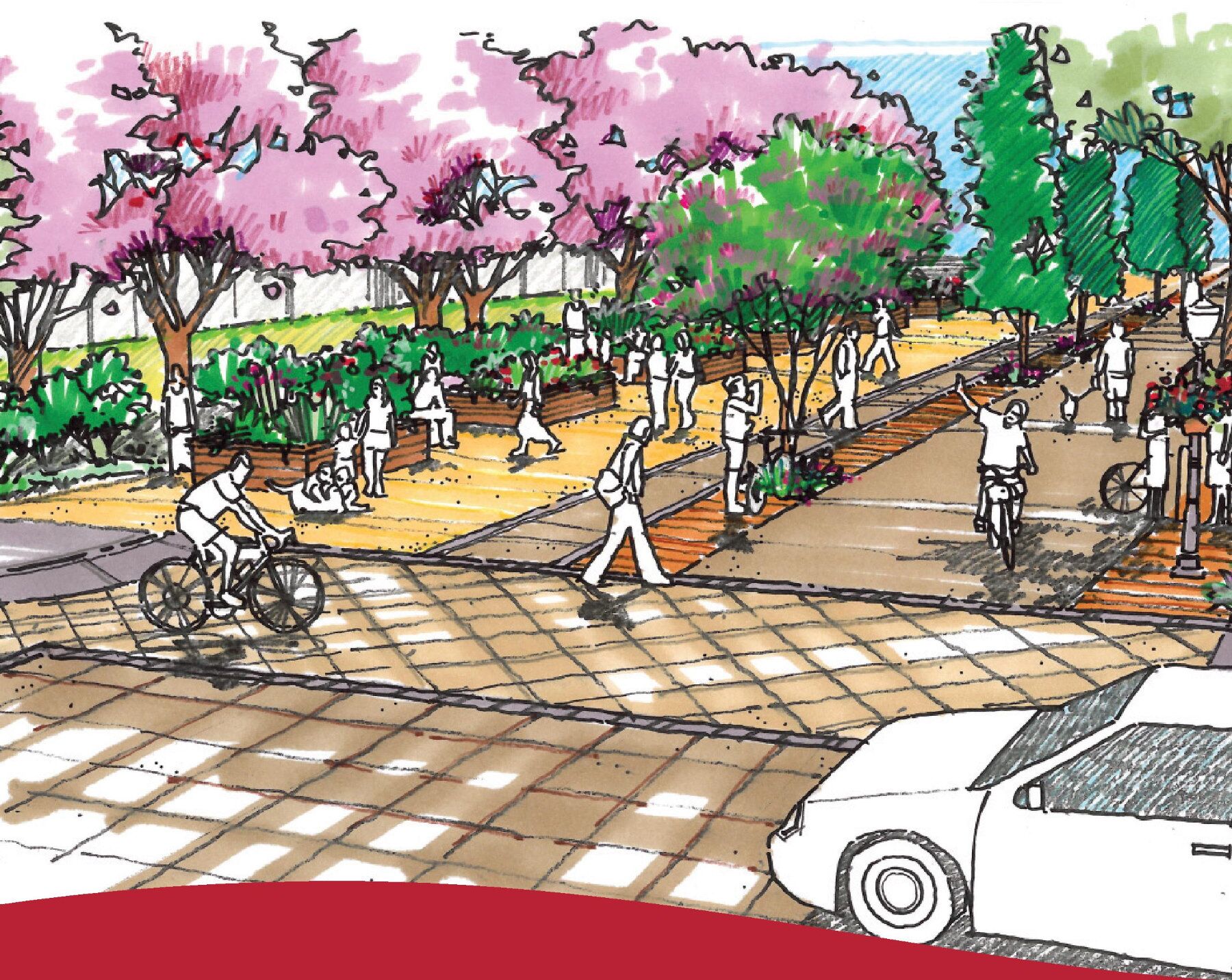
Below is an artist’s rendition of a street crossing of L Street, proposed as a linear park. The developers of this study chose to use this vision of L Street as the cover of the document.
This document was developed over a seven-month period after a previous year of a survey (of over 1100 Arcata residents and visitors), analysis, discussion, and planning. Involved parties included:
- City Staff:
- Karen Diemer (then Environmental Service Deputy Director; now Arcata City Manager)
- Mark Andre, Director of Environmental Services
- Doby Class, Director of Public Works
- Morgan Kessler, Public Works
- a 13-person Steering Committee
- 28 representatives from 19 local organizations or agencies
- the North Coast Region Project Manager of the California State Coastal Conservancy agency
- engineering consultants Winzler & Kelly (since taken over by GHD, in 2011)
- Planwest Partners
- Alta Planning + Design, Portland
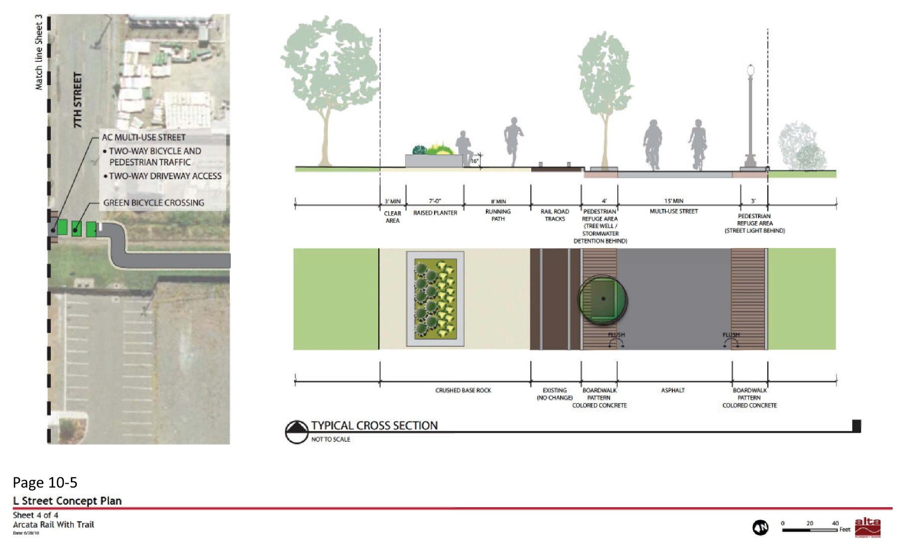
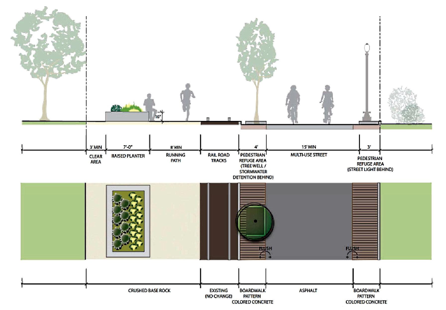
When you view the document or selected pages about L Street, you may be struck by the level of thoughtfulness and detail that went into this design. The 6-page section on the concept plan for L Street includes tree locations, lighting suggestions, potential food cart locations, curb bulb-outs, signage, mid-block bollards to prevent through traffic, details on street intersections, community garden areas, and shared “multi-use street” designations — what we are now calling by the Dutch name “woonerf” — for motor vehicle access for existing garages and homeowners’ needs.
The document contains sentences such as: “Implementing the Arcata RWT [Rails With Trails] will help the region achieve a world-class recreation and transportation system. A multi-use trail facility will result in expanded recreation and mobility options for Arcata, Eureka, and Humboldt County residents and visitors, especially those who seek to integrate a healthy lifestyle into their daily activities.”
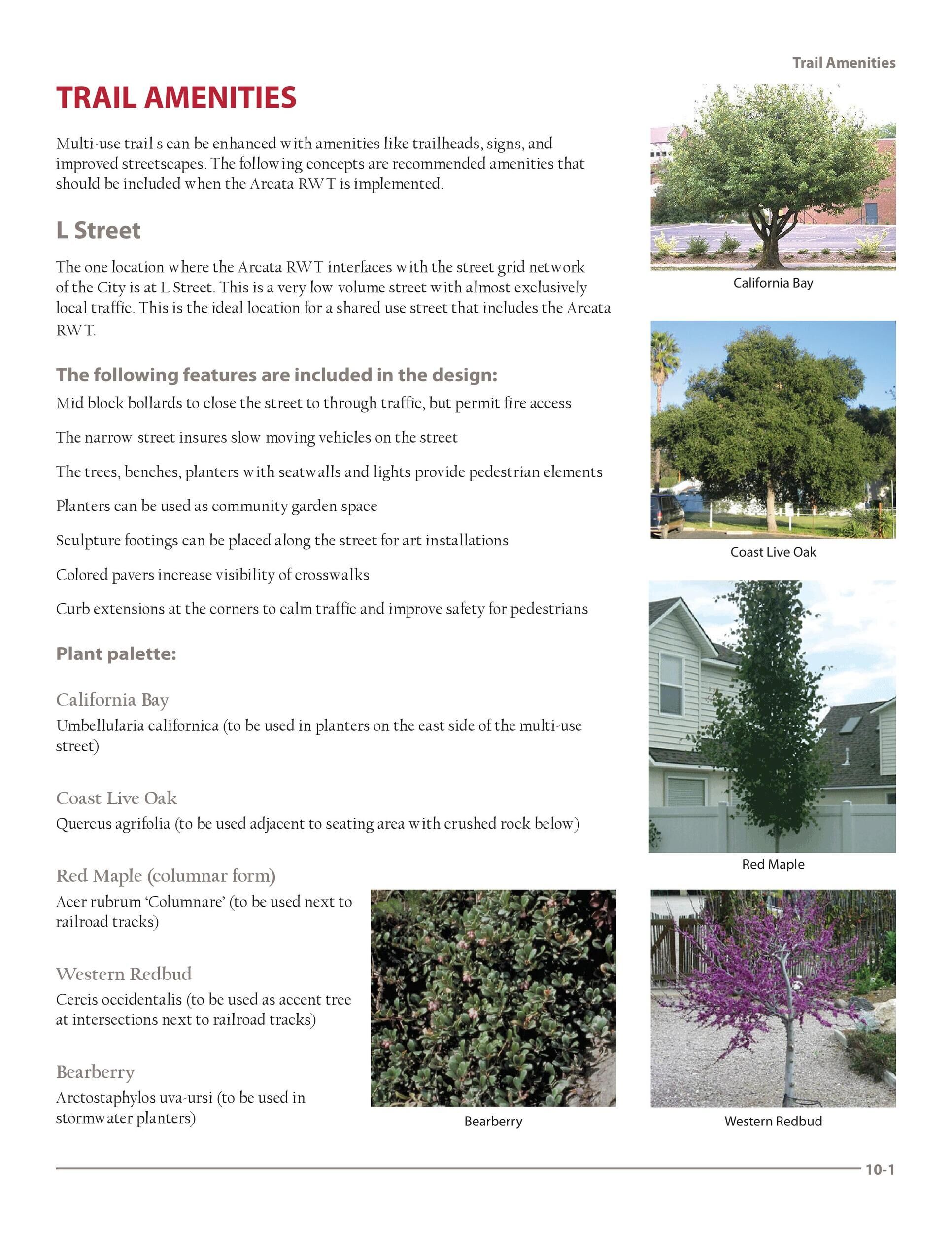
From the document, page 10-1:
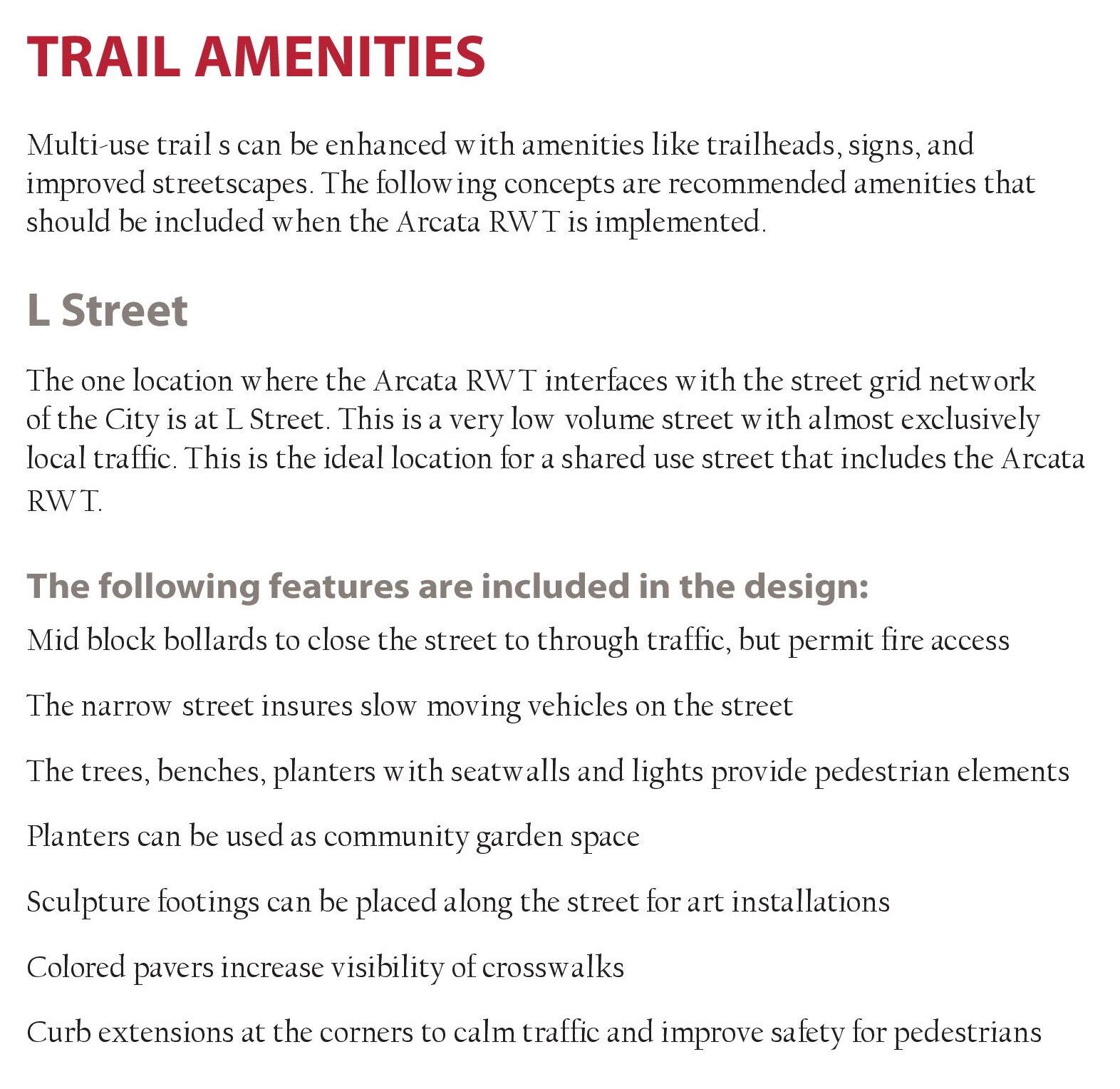
The one location where the Arcata RWT interfaces with the street grid network of the City is at L Street. This is a very low volume street with almost exclusively local traffic. This is the ideal location for a shared use street that includes the Arcata RWT [Rail With Trail]. The following features are included in the design:
Mid block bollards to close the street to through traffic, but permit fire access.
The narrow street insures slow moving vehicles on the street.
The trees, benches, planters with seatwalls and lights provide pedestrian elements.
Planters can be used as community garden space.
Sculpture footings can be placed along the street for art installations.
Colored pavers increase visibility of crosswalks.
Curb extensions at the corners to calm traffic and improve safety for pedestrians.
In short, everything that we have been talking about as being desired transportation and quality-of-life benefits to be included in the Gateway Area Plan is in this document —
In explicit detail.
In short, everything that we have been talking about as being desired transportation and quality-of-life benefits to be included in the Gateway Area Plan is in this document — in explicit detail. In looking at it, you may well wonder: “Why go further and try to re-create something that has already been developed?”
Please review the images and documents here and judge for yourself. This was not a minimal study by a small number of people. This plan involved much thought from a wide variety of input, and included many well-known and acknowledged individuals.
Our great thanks goes to Arcata residents Patricia Cambianica and Jim Becker for finding this document and insisting that it be looked at for its relevance in the development of the Gateway Area Plan, and, specifically, for the creation of the L Street Linear Park. For more information on the petition to designate the L Street corridor as a linear park go to https://www.arcatalinearpark.org/
For more information on the L Street pathway and linear park, with images, maps, quotes from the Transportation Safety Committee Chair Dave Ryan, issues with the Todd Tregenza presentation to the City Council and Planning Commission, videos and transcriptions from Transportation Safety Committee meetings, how the City does not have the legal rights to build a street there… and more … go to the L Street Pathway page on this website, here.
From the “Arcata Rail With Trail Feasibility Study and Operations Plan” document:
“L Street will be where the city and the trail converge, creating a vibrant community gathering space.” Artist’s rendering showing elements of a typical intersection of an east-west city street and the L Street linear park. Note the multi-use roadway on the right — a woonerf.

Here is the “L Street Concept Plan” — starting from the northern end. In these diagrams, North is to the left. On the upper-left corner we can see the boats of the previous occupant (Arcata Marine) of where Chris Richards Automotive now is. To the right of that are the apartments between 12th & 13th on L. Note the multi-use roadway that serves as a driveway to the apartments. In the block of text the lower-right of the faux roundabout, we see the words “Beginning of multi-use street (Woonerf).”

Continuing southward along the L Street corridor. The pathway for these blocks are still multi-use. Note the words along the top of the image: “Block closed to through traffic.” This is achieved with mid-block bollards.
11th (on the left) to 9th Street (on the right). At the lower right is the Northcoast Children’s Services building. To the left of that is North Bay Automotive. Above it are the storage buildings at 9th & L.
9th (on the left) to 7th Street (on the right). The green roof on the building at the lower right is the Tomas Building (Open Door Clinic). On the far right side above that are the Devlin Cottages. The Creamery Building block is at the lower left.
Section of the above page:
“Project Design Features” — pages 8-7 through 8-10 in the document.
Acknowledgements, Steering Committee, and Stakeholders:
The full document: