L Street – K Street Couplet:
Does the City have the Rights-of-Way to construct this?
A major component of the December 2021 draft Gateway Plan involves splitting the vehicle traffic now on K Street. The plan proposes that K Street — now a two-way street with one lane in each direction and parking on both sides — be converted to be a one-way one-lane street, with parking on the west side (left side when going north) and a separate bike line and wide sidewalks on the east side. The south-bound traffic from Alliance Road to Samoa Boulevard would be carried by a newly-built L Street, also one-way one-lane with parking on one side of the street (the east side) and the existing Rail-to-Trail L Street Pathway on the west side.
K Street and L Street then form a “Couplet” — much like the pair of one-way couplet streets downtown, G Street and H Street. But with a major difference: G Street and H Street both have two lanes of traffic. In the draft plan, K and L would each only have one lane. If a delivery truck is stopped on G or H Street, we use the other lane to get by. That would not be the case on K or L Street, as designed.
The idea is that it would it would ease the congestion at the 11th & K Streets intersection — which it would, a little — and that it would make the pedestrian and bike crossings of K Street far easier, also true. With well-designed bulb-outs on a one-way one-lane street, a walker or bicyclist would only have to cross a twelve-foot “danger zone” where cars might be coming — and they’d only be arriving from one direction. With a two-way road cars come from both sides. So having two separate one-way streets is far safer for the pedestrian. Installing well-placed stop signs on K Street would make it safer too — but that’s another conversation.
But this article is about something more immediate: To me (and other members of the community who’ve been observing this situation) it does not look like the L-K Street Couplet could ever get built. And why not? Because the City does not own the land where L Street would have to be. The City does not have the rights-of-way. Look at the maps below and see for yourself.
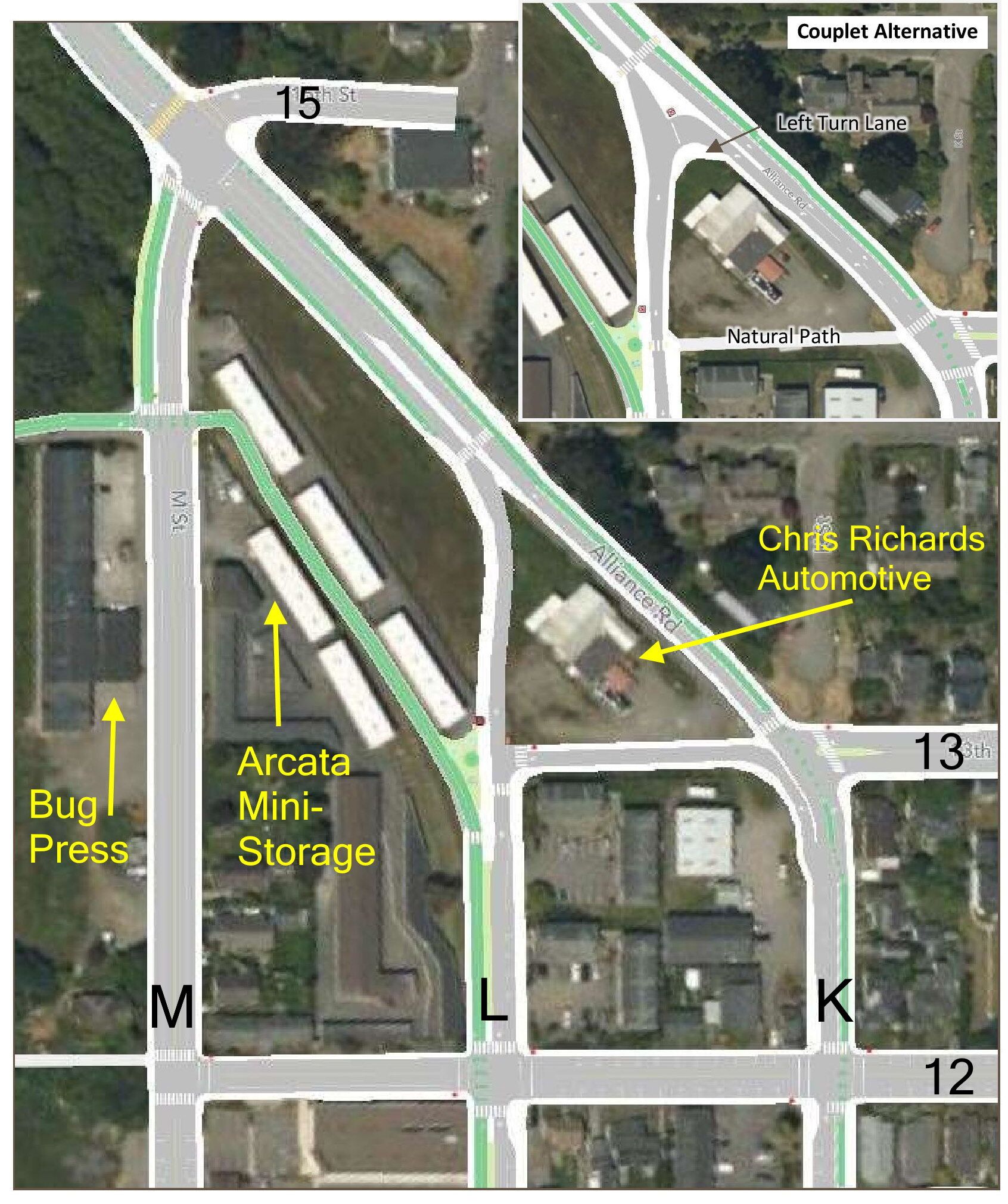
Shown here is the top of the L-K Street Couplet, where the couplet would intersect with Alliance Road. People driving north on K Street might need a turn-around to loop back down on L Street. In the main photo, there is a new road built as a stub of 13th Street, just south of Chris Richards Automotive. The inset shows an alternative, with a left-turn lane on Alliance to make a sharp 135-degree turn to go south on L Street — which might be difficult for a semi-truck or a fire engine.
This image taken from Page 75 of the December draft plan.
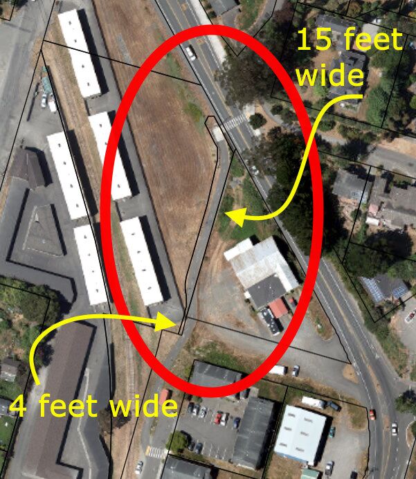
Compare this image with the drawing below, which includes the property lines.
The property lines from Arcata’s Geographic Information System (GIS) are superimposed over the diagram above of L & K Streets. Scroll down for a more detailed image also.
The City’s GIS system is accessed at this link — you may want to see this for yourself. The Community Development Department could make a much better map and depiction for us, but so far that does not seem to be their interest.

Purists will note that these lines are not exactly positioned. The are close enough — and any small discrepancy in position is not the problem.
The problem can be seen at a glance. In the area between 13th Street and Alliance, in the spot where a theoretical “L Street” would go — there is no right-of-way for the width of even one lane of a city street.
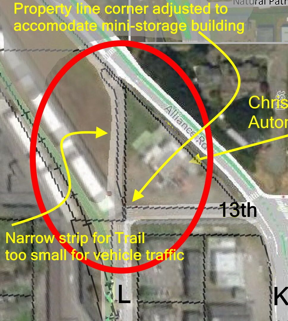
This funny-shaped sliver of land was designed for the trail that is there. And then the lower tip was further constricted because there was a previously-existing inconvenient building in the way.
Further, the property lines were adjusted at some point to accommodate the southern corner of the mini-storage buildings — so there isn’t a straight continuation of where L Street would go.
As to the “Couplet Alternative” in the upper-right inset — Clearly that plan would be taking the upper triangle area and the left-hand edge off the Chris Richards property. Without the rights to do this, what are the City planners thinking?

Certainly the City knows of this situation. And the Community Development Department has been asked again and again to explain this to us.
There are a variety of questions, and for each one there should be a Yes-or-No answer.
- Either the City has the rights to the land they will need to construct a new L Street that goes all the way to Alliance, or they don’t. Which is it?
- Either the City is planning on chopping off the corner of the mini-storage building, or they are convinced they do not need to. Which is it?
- If the City does not have the rights for this proposed construction of L Street, and if they cannot get the rights, either they are figuring on using Eminent Domain as a means of taking the property — which they have assured the public that they will not do — or they have some other idea in mind. Which is it?


Conclusion
From the looks of things, the City does not have the rights-of-way to build this road.
The December draft Gateway Plan presents this L-K Street Couplet as something that could happen. But it sure doesn’t look that way.
The area where the proposed roads are intended to be placed is on private property. And there is a corner of a building in the way.
Either the City knows something that they are not telling us about, or they are bluffing, figuring the property owners will give in. Do they intend to put pressure on the land-owners? Or what? What are the possibilities here? I don’t know.
Can we get a straightforward answer on this:
Does the City have the rights-of-way to construct a new L Street that extends to Alliance, as shown — or not?
Please tell us.
Two points that are elsewhere in many places on this website:
The people, in delegating authority, do not give their public servants the right to decide what is good for the people to know and what is not good for them to know. The people insist on remaining informed so that they may retain control over the instruments they have created.
That’s from the opening paragraph of the Brown Act, the law in the State of California that’s dedicated to transparency in government.
And:
If a plan is not feasible, then it is not a plan at all.

