Historic Resources vs. “older homes”
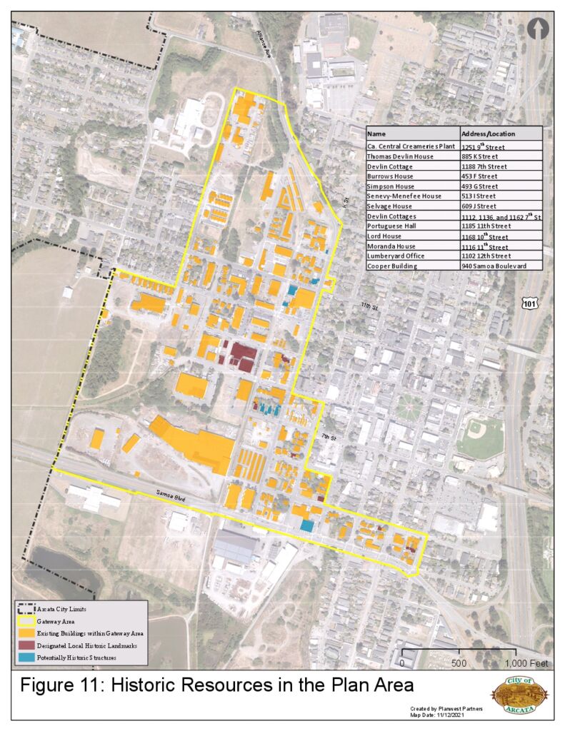
Below is a map of the historic resources in the plan area. As can be seen, there is a very small number of legally designated Historic Resources. Of the 12 sites shown, 7 are Designated Local Historic Landmarks and 5 are Potentially Historic Structures. The Creamery building is a Designated Local Historic Landmark. Portuguese Hall is a Potentially Historic Structure.
Providing a list of the legally designated Historic resources is indeed one way to look at the historical content of this area. Another way to view the historic value of these neighborhoods of Arcata would be to imagine what a residential area would be like with, say, two or three — or four or five or six, or a whole block — of the pre-1920 houses torn down and replaced with a 3- or 4- or 5-story apartment building.
In driving around Eureka we can see this — a totally incongruous apartment building set right next to some beautiful Victorians. It’s currently less common in Arcata.
How many houses are in the Gateway area?
Parts of the Gateway area are industrial in nature. Other parts are composed of single-family residences. While not officially designated as Historic Resources, there is no question that the older housing stock adds considerable charm to the Arcata.
It’s not always easy to get an exact count of the houses. Sometimes there are 3 or 4 houses on one lot — would that be 3 or 4 single-family-houses ? And sometimes a large house has been split into separate units — do you count that as a pre-1920 house, or do you count it as an “apartment” ?
By a good estimate, there are somewhere between 85 to 100 houses in the Gateway area. With the exception of the 18 new townhouses on “Creamery Alley” off of O Street in the northwest and the 8 houses on 10th Street between O and Q, almost all of the structures are pre-1920 or pre-1900.
Historic Resources in the Gateway area

This is a map of only the Designated Historic Landmarks and Potentially Historic Structures. Page 100 of the Draft Plan. Again, as an example, Portuguese Hall is a Potentially Historic Structure — not Designated.
Aerial View of Historic Houses
Below is an aerial image from 7th Street, looking north. The point-of-view is from a spot above the current Amerigas site. All the blocks to the left (west) of K Street are part of the Gateway area. According to the December 2021 Draft Plan, six-story apartments could be built across the street from these homes.
The Redwood City Downtown Precise Plan includes buffer zones along streets that are adjacent to existing lower-height commercial buildings and single-family residences.
The Redwood City Downtown Precise Plan, on the building’s site the portion of the building along the street is 3 stories, and then set back from the street the building can be 5-8 story maximum. The tallest buildings in the plan are 12 Stories, but the maximum along the commercial streets is 5-8 story.
[In Arcata, this might correspond to a 2 Story height along the street, and a 4 Story maximum height along commercial streets and adjacent to single-family residences.]


