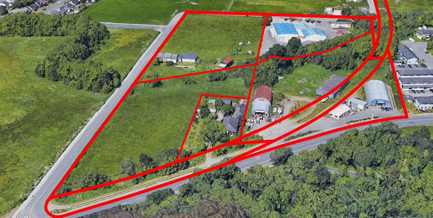
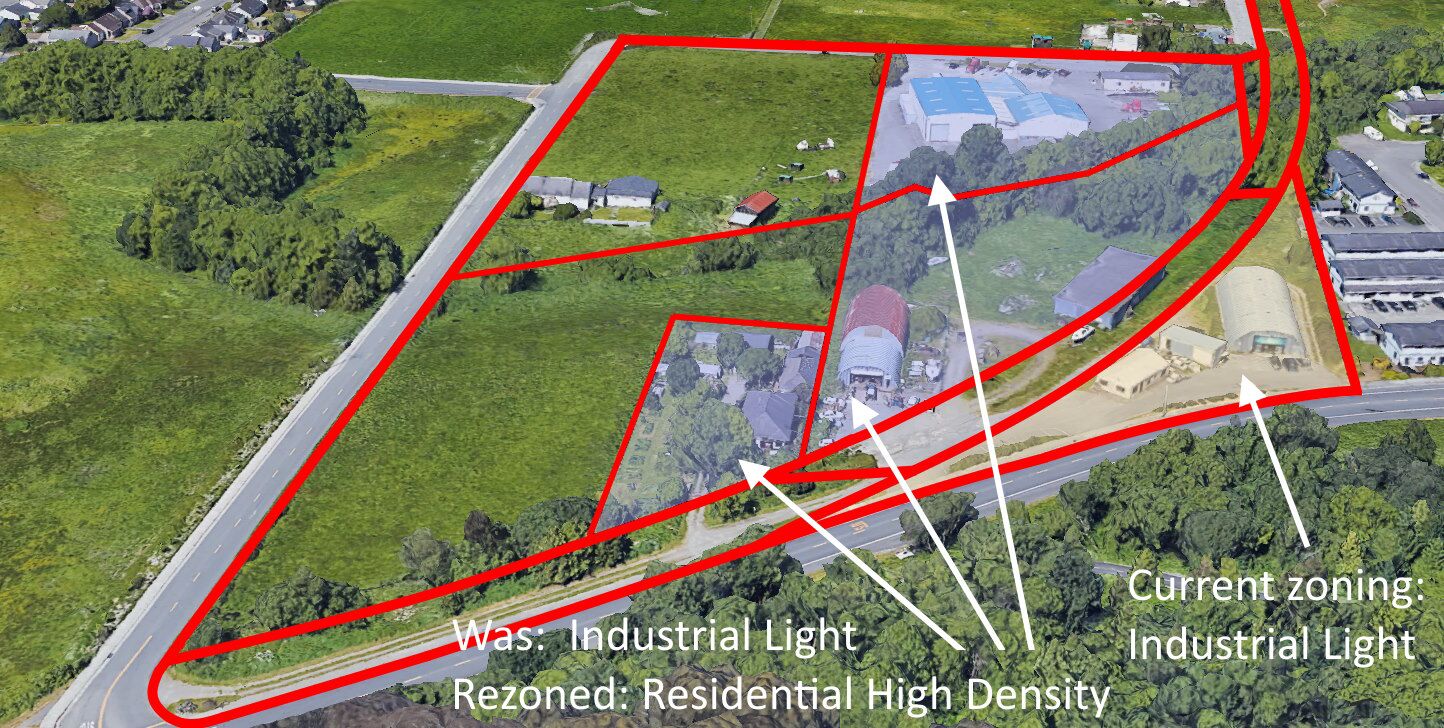
The Planning Commission inadvertently created a “spot zoned” parcel — and it is actually a spot-zoned portion of a parcel.
The question is now: What is the Planning Commission going to do? Leave it as it is, and hope no one wants to ever redevelop the “blighted” buildings? That does not seem like a thoughtful path. Or will they figure out how to make this improper rezoning correct.
What happened
At its April 27, 2023, meeting, even though a discussion of “Land Use Map Amendments” — that is, rezoning — was not on the agenda, the Planning Commission took on the rezoning of several areas of Arcata. Included was an area called “Exhibit 5” that appears to be a rezoning of five Assessor Parcels.
Here’s the map as supplied by the Community Development Department.
The southern two parcels show a current zoning of Agricultural – Residential, and the northern three parcels show a current zoning of Industrial Light.
The proposed rezoning was from the A-R and I-L designations to Residential High Density. In the discussion and eventual resolution, the A-R parcels were determined to stay the same, and the I-L parcels were given the recommendation to be re-zoned as Residential High Density.
The streets bordering the parcels appear to be 17th Street to the south; Q Street to the west, and a curved, unknown parcel to the east. The parcels shown do not go all the way to Alliance Road.
The Planning Commissioners need full information to make their decisions. Among the information that is missing from this map is: What are those curved parcels? Plus, as sharp-eyed viewers can see in the enlargement below, Parcel APN 505-161-031 is unusual. It is two pieces of land, separated by a distinct other parcel — that curved area. The two APNs that are circled in red are the same number, even though they are not connected. Those two non-contiguous pieces of land are actually a single APN.
In this image, the orientation has been rotated about 17 degrees, for no other reason than to have 17th Street be parallel to the edge of the image. This orientation is used in the images that follow.

Here’s the image from the City’s GIS website, with the property boundaries colored in bright green, to provide further clarity.

This next image corresponds with the City-supplied map of this proposed area to be rezoned.

And then color-coding the parcels to show what the current zoning is.
And some labels added for orientation. Alliance Road is shown as pale yellow. The City boundary is shown as a dashed red line on the west (left) side.
The piece of land that has Moon’s Cycles on it is on the same APN as the piece of land that has General Machine on it.

Next we’ll add the APN parcel numbers and the parcel sizes. We can note:
- The eastern A-R parcel 505-061-034, which looks as though it might extend to Alliance Road, does not actually go all the way to Alliance Road.
- APN 505-161-031 is split into two non-contiguous pieces. The area proposed for rezoning includes the south-western (left) part, and does not include the north-eastern (right) part.
- The railroad rights-of-way are actual APN-designated parcels with independent parcel numbers. The railroad parcels are not included in the proposed rezoning. The sizes of the three railroad parcels shown are 161-009 = 1/04 acres; 161-010=0.47 acres; 161-161-029=0.40 acres. All the railroad parcels are not currently zoned in Arcata’s Land Use Code, not currently zoned in the General Plan.

Here is that non-contiguous parcel, filled in with light blue.

Here are some oblique views, looking west. The parcel lines are not exactly drawn but are a close approximation to the actual GIS parcel lines.
Here is what the Planning Commission recommended, at their April 27, 2023, meeting. Light blue is the rezoned area. Was: Industrial Light. Recommended: Residential High Density.
The light yellow area was not rezoned and has a current zoning of Industrial Light.

Conclusion
Clearly the owners of the existing structures have been using the property of the railroad parcels for decades. We do not know if there are any legal easements for crossing the railroad parcels. There may be an opportunity for Adverse Possession, to effectively remove those curved railroad parcels and legally give that land to those persons who have been using it.
For the Planning Commission, a decision: Ask staff to make new drawings and exhibits, and make this right.
This is an usual situation. But there are other unusual situations on other parcels. What happened with this rezone recommendation gives support to the wish that ALL rezone considerations have better maps (such as from the City’s GIS website) and that they be scrutinized by multiple persons.
To jump to a summary of what could be built on this site, click here.
Companion articles:
- Re-Zoning Arcata: The Big View and aerial images
- Rezoning Arcata: 17th & Q – from Ag Land and Industrial Light — to Residential High Density
- Rezoning Arcata: 17th & Q proposed as Residential High Density – More images tell the story
- Zoning

