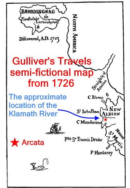
Swift describes the location of Brobdingnag and its geography in Part II of Gulliver’s Travels and provides a map showing where it is. The fictional map indicates that Brobdingnag is located on the northwest coast of North America, around probably what is now British Columbia. In the novel, the map dates from 1703.
 The map shows (from south to north) Point Monterey, Port Sir Francis Drake (now San Francisco), Cape Mendocino (Capetown, south of Ferndale), Cape St. Sebastian (just north of Brookings, Oregon), Cape Blanco (north of Port Orford, south of Bandon, Oregon) and the semi-mythical Strait of Anián (perhaps the Straits of San Juan de Fuca and the San Juan Islands, between the U.S. and Canada, between Seattle and Victoria, B.C.) and depicts Brobdingnag as a peninsula extending west into the Pacific to the north of the Straits.
The river in the crude fictional map more or less corresponds to the location (but not the angle of flow) of the Klamath River.
The little blip of a point just below the river would correspond to Trinidad Head. Just below that point would be Humboldt and Arcata Bay.
On this fictional map from Gulliver’s Travels, written in 1726, I have marked where Arcata would be located with a red star.
Jonathan Swift’s novel is considered a satirical masterpiece and among the 100 best novels of all time. His satirical essay “A Modest Proposal” is considered to be one of the greatest examples of sustained irony in the history of the English language.
George Wittkowsky in 1943 wrote that Swift’s main target in “A Modest Proposal” was not the conditions in Ireland, but rather the can-do spirit of the times that led people to devise a number of illogical schemes that would purportedly solve social and economic ills.
The Humor section on this website contains a bit of satire, written in May, 2022, called “The Gateway Plan: A modest proposal.”
Just as Swift’s “A Modest Proposal” is described, the target here is the Gateway Plan.
The Gateway Plan was anticipated 300 years ago, in Swift’s words, as:
“The can-do spirit of the times that led people to devise a number of illogical schemes that would purportedly solve social and economic ills.“

