 In the December 2021 draft Gateway plan, there are four “Land Use Designations” or Neighborhoods depicted. It has been suggested that there be more neighborhood areas, so that new construction can be better designed to fit in with Arcata’s needs for that one area, as differentiated from other areas. One new district could be centered around the Creamery.
To the right is the Land Use Designation map from the draft plan, with the addition of proposed quantities of “housing units” for each zone. The total shown is 3,500 housing units.
Back in May 2022, the notion of a separate Land Use Designation was suggested for what had already been recognized as the Creamery District. Adding another district in that portion of the Gateway area would allow the planners to more easily create the zoning codes (the Form-Based Code) which would regulate building height, massing, appearance, etc to better suit the special “Arcata-ish” aspects of the Creamery arts district.
1. Aerial view with the building heights proposed in the December 2021 draft plan
The line through the central portion is a potential “L Street Pathway” linear park and walking “mall” that would extend from Alliance Road at the north and go to Samoa Boulevard at the south. It would be a car-free area, adjacent to the Creamery District arts area, alongside The Pub restaurant and many future restaurants and shops. If the existence of this future wonderful walkable destination of Arcata could be decided upon, then building heights and building designs along its length could be determined in a creative and thoughtful manner.
This image shows the building heights along the L Street Pathway as 6-story, 7-story, and 8 story heights, as taken from the draft plan. These are NOT the Planning Commission’s recommendations on building height. The Planning Commission’s recommendations may be lower than what is shown here.
Update: What is shown here is “8-7-6-5” stories. The Planning Commission may instead recommend a maximum height of 7 stories, or a maximum height of 6 stories. Please be aware that with State “density bonus” laws, the actual building heights could be higher than what is shown.

With labels of known landmarks, for orientation.
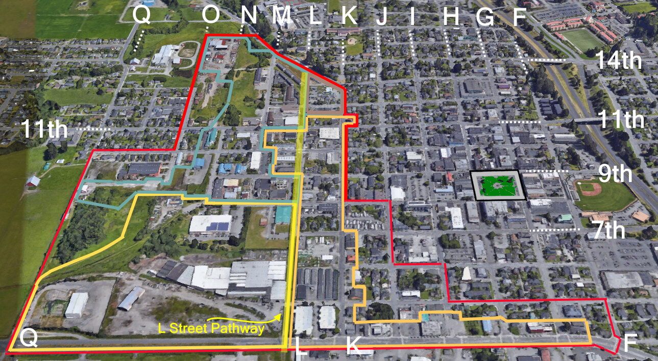
2. Aerial views showing a possible new district centered around the Creamery Building
At the September 13, 2022 Planning Commission meeting, the notion of adding or modifying the draft districts was brought up by Chair Julie Vaissade-Elcock. What is shown below is a first trial at a possible new Land Use Designation. Community Development Director David Loya has suggested a “round table” type discussion, with a plastic-laminated large map or satellite photograph on which lines could be drawn with erasable marker, to try out where appropriate neighborhood designations could be agreed upon and recommended.
This is a trial map, put here as a starting point to work from.
Here are the draft plan Zoning Designations, for orientation. The Plaza has been highlighted and street names added. Keep in mind that in this aerial view, because of the angle, that the appearance of the blocks in the rear of the image are smaller than how the blocks appear at the front — and thus judging the size of the actual areas cannot be “eyeballed.” Instead, count the blocks.

In the draft, the “Corridor” zone went along L Street and K Street from Samoa up past 11th Street, at which point the zone changed to “Neighborhood.” (The “Corridor” also runs along the north side of Samoa Boulevard, from K to to F). The “Corridor” also went a half-block or so west between 9th & 11th, to include the AgSales building, the Northcoast Children’s Services building and North Bay Automotive, but not the Holly Yashi building or the Brio/YouthAbility Thrift Store, all of which would be in the “Hub” district with a proposed building height of one story taller than the “Corridor” district.
In the view shown below, the “Corridor” zone ends after the AmeriGas lot, at 7th Street, and so ends before the row of the Devlin Cottages on the north side of 7th Street.
Here is the same image with labels added, for orientation:


